File:Bolivia satellite deforestation 1986 2001.jpg
Bolivia_satellite_deforestation_1986_2001.jpg (540 × 448 pixel, dimensione del file: 103 KB, tipo MIME: image/jpeg)
| Questo file e la sua pagina di descrizione (discussione · modifica) si trovano su Wikimedia Commons (?) |
Dettagli
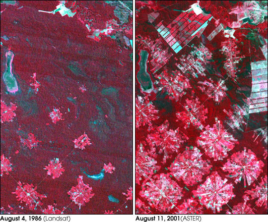
| Descrizione |
Deforestation in Santa Cruz, Bolivia. From Earth Observatory : "These images from 1986 and 2001 are for an area of tropical dry forest lying east of Santa Cruz de la Sierra, Bolivia. Since the mid-1980s, the resettlement of people from the Altiplano (the Andean high plains) and a large agricultural development effort (the Tierras Baja project) has lead to this area’s deforestation. Soybean production began in earnest in the early 1970s following a substantial increase in the crop’s world price. The pie or radial patterned fields are part of the San Javier resettlement scheme. At the center of each unit is a small community that includes a church, bar/café, school, and soccer field. The rectangular, light colored areas are fields of soybeans cultivated for export, mostly funded by foreign loans. The dark strips running through the fields are windbreaks, which are advantageous because the soils in this area are fine and prone to wind erosion. The 1986 Landsat image (left) was acquired on August 4, 1986, and the ASTER image (right) on August 11, 2001." Image courtesy NASA/GSFC/MITI/ERSDAC/JAROS, and U.S./Japan ASTER Science Team Any and all materials published on the Earth Observatory are freely available for re-publication or re-use, except where copyright is indicated. We ask that NASA's Earth Observatory be given credit for its original materials. |
| Fonte | NASA |
| Autore | NASA |
Licenza
| Questo file è nel pubblico dominio perché creato dalla NASA. La politica sul copyright della NASA afferma che «il materiale della NASA non è protetto da copyright a meno che non sia specificato altrimenti». (NASA copyright policy e JPL Image Use Policy). | ||
 |
Attenzione:
|
Registro originale del caricamento
- 2005-08-07 18:21 Delorme 540×448×8 (105607 bytes) Deforestation in Santa Cruz, Bolivia. From [[Earth Observatory |http://earthobservatory.nasa.gov/Newsroom/NewImages/images.php3?img_id=16274]] "These images from 1986 and 2001 are for an area of tropical dry forest lying east of Santa Cruz de la Sierra
Cronologia del file
Fare clic su un gruppo data/ora per vedere il file come si presentava nel momento indicato.
| Data/Ora | Miniatura | Dimensioni | Utente | Commento | |
|---|---|---|---|---|---|
| attuale | 19:58, 3 gen 2007 | | 540 × 448 (103 KB) | Frog Bot | semi-automatic upload by user:bayo from fr.wikipedia.org "Image:Bolivia satellite deforestation 1986 2001 .jpg" |
Pagine che usano questo file
La seguente pagina usa questo file:
Utilizzo globale del file
Anche i seguenti wiki usano questo file:
- Usato nelle seguenti pagine di fr.wikipedia.org:
- Usato nelle seguenti pagine di no.wikipedia.org: