File:COVID-19 Prevalence in California by county.svg

File originale (file in formato SVG, dimensioni nominali 338 × 400 pixel, dimensione del file: 74 KB)
| Questo file e la sua pagina di descrizione (discussione · modifica) si trovano su Wikimedia Commons (?) |
Dettagli
| Descrizione |
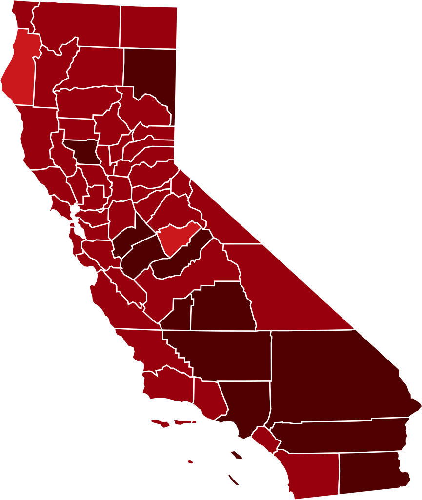
This map shows confirmed cases of w:en:COVID-19, coded by percentage of population confirmed to be infected as of 29 March 2021. The data is used from the data as aggregated and released by Johns Hopkins University and US census (2019 population estimate). As this is a current outbreak, the map might not be up to date. 10.00%+ Confirmed infected
3.00%-10.00% Confirmed infected
1.00%-3.00% Confirmed infected
0.30%-1.00% Confirmed infected
0.10%-0.30% Confirmed infected
0.03%-0.10% Confirmed infected
0.00%-0.03% Confirmed infected
no confirmed cases or no data
The design is based on blank maps available in Public Domain (created by Yiling Chen from TIGER shapefiles), the color scheme is based on color brewer. The script for creating the maps was written by Sukolsak Sakshuwong and Lodewijk Gelauff.
|
||||
| Data | |||||
| Fonte | Based on File:Blank_California_Map.svg by user:Thadius856 | ||||
| Autore | The design is based on blank maps available in Public Domain, the color scheme is based on the design created by platypeanArchcow (PD). The script for creating the maps was written by Sukolsak Sakshuwong and Lodewijk Gelauff. |

Licenza
| Io, detentore del copyright su quest'opera, la rilascio nel pubblico dominio. Questa norma si applica in tutto il mondo. In alcuni paesi questo potrebbe non essere legalmente possibile. In tal caso: Garantisco a chiunque il diritto di utilizzare quest'opera per qualsiasi scopo, senza alcuna condizione, a meno che tali condizioni siano richieste dalla legge. |
Cronologia del file
Fare clic su un gruppo data/ora per vedere il file come si presentava nel momento indicato.
| Data/Ora | Miniatura | Dimensioni | Utente | Commento | |
|---|---|---|---|---|---|
| attuale | 08:17, 14 mar 2021 | | 338 × 400 (74 KB) | Eiabot | new data: 13 March 2021 |
| 09:59, 2 mar 2021 |  | 338 × 400 (74 KB) | Eiabot | new data: 01 March 2021 | |
| 08:23, 21 feb 2021 |  | 338 × 400 (74 KB) | Eiabot | new data: 20 February 2021 | |
| 08:58, 18 feb 2021 |  | 338 × 400 (74 KB) | Eiabot | new data: 17 February 2021 | |
| 09:00, 14 feb 2021 |  | 338 × 400 (74 KB) | Eiabot | new data: 13 February 2021 | |
| 08:32, 27 gen 2021 |  | 338 × 400 (74 KB) | Eiabot | new data: 26 January 2021 | |
| 09:58, 26 gen 2021 |  | 338 × 400 (74 KB) | Eiabot | new data: 25 January 2021 | |
| 08:52, 20 gen 2021 |  | 338 × 400 (74 KB) | Eiabot | new data: 19 January 2020 | |
| 08:43, 17 gen 2021 |  | 338 × 400 (74 KB) | Eiabot | new data: 16 January 2020 | |
| 08:16, 16 gen 2021 |  | 338 × 400 (74 KB) | Eiabot | new data: 15 January 2020 |
Pagine che usano questo file
La seguente pagina usa questo file:
Utilizzo globale del file
Anche i seguenti wiki usano questo file:
- Usato nelle seguenti pagine di ar.wikipedia.org:
- Usato nelle seguenti pagine di en.wikipedia.org:
- Usato nelle seguenti pagine di es.wikipedia.org:
- Usato nelle seguenti pagine di fa.wikipedia.org:
- Usato nelle seguenti pagine di id.wikipedia.org:
- Usato nelle seguenti pagine di zh.wikipedia.org: