File:East African oryx Oryx beisa distribution map 2.png

Dimensioni di questa anteprima: 383 × 599 pixel. Altre risoluzioni: 153 × 240 pixel | 568 × 889 pixel.
File originale (568 × 889 pixel, dimensione del file: 739 KB, tipo MIME: image/png)
| Questo file e la sua pagina di descrizione (discussione · modifica) si trovano su Wikimedia Commons (?) |
Dettagli
| Descrizione |
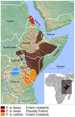
English: Geographical distribution of the East African oryx Oryx beisa. The map was created using the Generic Mapping Tools, GMT, version 5.1.2. |
| Data | |
| Fonte |
Opera propria usando:
Questa mappa in immagine è stata creata con GMT. |
| Autore | Darekk2 using the IUCN Red List spatial data and GLOBE grids |
Licenza
Attribution: The author of the work and
- the IUCN Red List spatial data.
IUCN (International Union for Conservation of Nature) 2008. Oryx beisa. In: IUCN 2015. The IUCN Red List of Threatened Species. Version 2015.2. http://www.iucnredlist.org. Downloaded on 14 July 2015. - GLOBE grids
(for credits see the Source section)
The NGDC in it's copyright notice says:
As required by 17 U.S.C. 403, third parties producing copyrighted works consisting predominantly of the material produced by U.S. government agencies must provide notice with such work(s) identifying the U.S. Government material incorporated and stating that such material is not subject to copyright protection within the United States. (...).
Questo file è disponibile in base alla licenza Creative Commons Attribuzione-Condividi allo stesso modo 4.0 Internazionale
Attribuzione: The author of the work
and the IUCN Red List spatial data
and GLOBE
(see above and the Source section)
and the IUCN Red List spatial data
and GLOBE
(see above and the Source section)
- Tu sei libero:
- di condividere – di copiare, distribuire e trasmettere quest'opera
- di modificare – di adattare l'opera
- Alle seguenti condizioni:
- attribuzione – Devi fornire i crediti appropriati, un collegamento alla licenza e indicare se sono state apportate modifiche. Puoi farlo in qualsiasi modo ragionevole, ma non in alcun modo che suggerisca che il licenziante approvi te o il tuo uso.
- condividi allo stesso modo – Se remixi, trasformi o sviluppi il materiale, devi distribuire i tuoi contributi in base alla stessa licenza o compatibile all'originale.
Cronologia del file
Fare clic su un gruppo data/ora per vedere il file come si presentava nel momento indicato.
| Data/Ora | Miniatura | Dimensioni | Utente | Commento | |
|---|---|---|---|---|---|
| attuale | 01:18, 20 giu 2016 | | 568 × 889 (739 KB) | Darekk2 | added border between Sudans |
| 19:07, 15 lug 2015 |  | 568 × 889 (738 KB) | Darekk2 | thinner borders in the inset map | |
| 18:51, 15 lug 2015 |  | 568 × 889 (739 KB) | Darekk2 | thinner borders in the inset map | |
| 17:11, 15 lug 2015 |  | 568 × 889 (739 KB) | Darekk2 | latin names to oblique (italics) | |
| 16:44, 15 lug 2015 |  | 568 × 889 (738 KB) | Darekk2 | User created page with UploadWizard |
Pagine che usano questo file
La seguente pagina usa questo file:
Utilizzo globale del file
Anche i seguenti wiki usano questo file:
- Usato nelle seguenti pagine di en.wikipedia.org:
- Usato nelle seguenti pagine di es.wikipedia.org:
- Usato nelle seguenti pagine di hu.wikipedia.org:
- Usato nelle seguenti pagine di ka.wikipedia.org:
- Usato nelle seguenti pagine di ko.wikipedia.org:
- Usato nelle seguenti pagine di nl.wikipedia.org:
- Usato nelle seguenti pagine di pl.wikipedia.org:
- Usato nelle seguenti pagine di ru.wikipedia.org:
- Usato nelle seguenti pagine di sco.wikipedia.org:
- Usato nelle seguenti pagine di sr.wikipedia.org:
- Usato nelle seguenti pagine di vi.wikipedia.org: