File:Ellington crater Berkel crater EW0252814064I.3band.plusmono.png
File originale (1 422 × 1 423 pixel, dimensione del file: 2,29 MB, tipo MIME: image/png)
| Questo file e la sua pagina di descrizione (discussione · modifica) si trovano su Wikimedia Commons (?) |
Dettagli
| Descrizione |
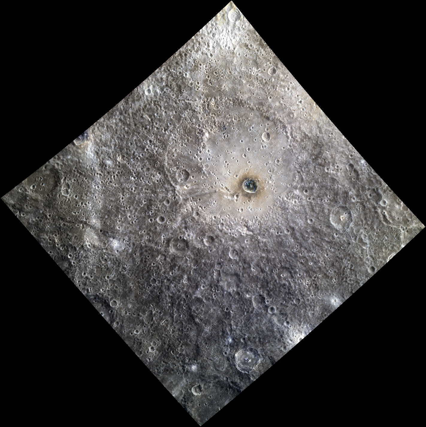
English: Date acquired: August 07, 2012 Image Mission Elapsed Time (MET): 252814064, 252814056, 252814060 Of Interest: Ellington basin, named in 2012 for American jazz legend Duke Ellington (1899-1974), is a peak ring basin covered in secondary craters. The prominent crater Berkel lies inside of the basin. Berkel's ejecta and floor exhibit differences in reflectance and color, indicating a heterogeneous local stratigraphy. This image was created by merging a color image with a monochrome image, in order to emphasize both the topography and the color of the area. The color portion of this image was acquired as part of MDIS's high-resolution 3-color imaging campaign. The 3-color campaign is a major mapping activity in MESSENGER's extended mission. It complements the 8-color base map (at an average resolution of 1 km/pixel) acquired during MESSENGER's primary mission by imaging Mercury's surface in a subset of the color filters at the highest resolution possible. The three narrow-band color filters are centered at wavelengths of 430 nm, 750 nm, and 1000 nm, and image resolutions generally range from 100 to 400 meters/pixel in the northern hemisphere. The monochrome portion of this image is part of MDIS's high-resolution surface morphology base map. The surface morphology base map covers more than 90% of Mercury's surface with an average resolution of 250 meters/pixel (0.16 miles/pixel or 820 feet/pixel). Images acquired for the surface morphology base map typically have off-vertical Sun angles (i.e., high incidence angles) and visible shadows so as to reveal clearly the topographic form of geologic features. |
| Data | |
| Fonte | IT DON'T MEAN A THING |
| Autore | NASA/Johns Hopkins University Applied Physics Laboratory/Carnegie Institution of Washington |
Licenza
| Questo file è nel pubblico dominio perché creato dalla NASA. La politica sul copyright della NASA afferma che «il materiale della NASA non è protetto da copyright a meno che non sia specificato altrimenti». (NASA copyright policy e JPL Image Use Policy). | ||
 |
Attenzione:
|
Cronologia del file
Fare clic su un gruppo data/ora per vedere il file come si presentava nel momento indicato.
| Data/Ora | Miniatura | Dimensioni | Utente | Commento | |
|---|---|---|---|---|---|
| attuale | 21:47, 15 ago 2020 | | 1 422 × 1 423 (2,29 MB) | Jstuby | Uploaded a work by NASA/Johns Hopkins University Applied Physics Laboratory/Carnegie Institution of Washington from [https://messenger.jhuapl.edu/Explore/Science-Images-Database/gallery-image-1067.html IT DON'T MEAN A THING] with UploadWizard |
Pagine che usano questo file
Le seguenti 2 pagine usano questo file:
Utilizzo globale del file
Anche i seguenti wiki usano questo file:
- Usato nelle seguenti pagine di ca.wikipedia.org:
- Usato nelle seguenti pagine di en.wikipedia.org:
- Usato nelle seguenti pagine di www.wikidata.org: