File:Finland-Norway border map.png
Non sono disponibili versioni a risoluzione più elevata.
Finland-Norway_border_map.png (514 × 290 pixel, dimensione del file: 93 KB, tipo MIME: image/png)
| Questo file e la sua pagina di descrizione (discussione · modifica) si trovano su Wikimedia Commons (?) |
Dettagli
| Descrizione |
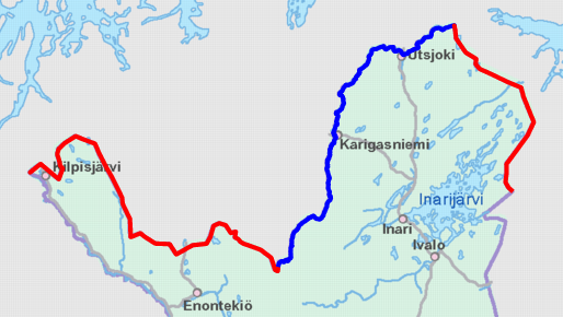
English: Schematic map of the Finland–Norway border. Land border highlighted in red and river border in blue.
Map cropped from the 1:4000000 background map provided by the NLS of Finland. Highlighted border is based on free numeric data provided by the NLS. Suomi: Karttakuva Suomen ja Norjan rajasta. Maaraja korostettu punaisella ja jokiraja sinisellä.
Karttapohja on otettu Maanmittauslaitoksen 1:4000000 taustakartasta, johon on lisätty värikorostus Maanmittauslaitoksen numeerisen aineiston avulla. |
| Data | |
| Fonte | https://tiedostopalvelu.maanmittauslaitos.fi/tp/kartta?lang=en |
| Autore | National Land Survey of Finland; color highlights added by Jmk |
Licenza

|
This file is licensed under the National Land Survey open data licence, version 1.0 (1 May 2012) published by the National Land Survey of Finland.
You are free to:
You must, through reasonable means:
The terms of this licence do not allow you to state in conjunction with the use of dataset(s) that the NLS supports or recommends such use. |
 |
| Attribuzione: contains map data from the National Land Survey of Finland Topographic Database 09/2012
|
Cronologia del file
Fare clic su un gruppo data/ora per vedere il file come si presentava nel momento indicato.
| Data/Ora | Miniatura | Dimensioni | Utente | Commento | |
|---|---|---|---|---|---|
| attuale | 12:12, 9 nov 2012 | | 514 × 290 (93 KB) | Jmk | User created page with UploadWizard |
Pagine che usano questo file
La seguente pagina usa questo file:
Utilizzo globale del file
Anche i seguenti wiki usano questo file:
- Usato nelle seguenti pagine di ckb.wikipedia.org:
- Usato nelle seguenti pagine di cs.wikipedia.org:
- Usato nelle seguenti pagine di de.wikipedia.org:
- Usato nelle seguenti pagine di en.wikipedia.org:
- Usato nelle seguenti pagine di es.wikipedia.org:
- Usato nelle seguenti pagine di fi.wikipedia.org:
- Usato nelle seguenti pagine di fi.wiktionary.org:
- Usato nelle seguenti pagine di hr.wikipedia.org:
- Usato nelle seguenti pagine di sv.wikipedia.org:
- Usato nelle seguenti pagine di uk.wikipedia.org: