File:German Empire states map.svg

Dimensioni di questa anteprima PNG per questo file SVG: 496 × 600 pixel. Altre risoluzioni: 198 × 240 pixel | 397 × 480 pixel | 635 × 768 pixel | 847 × 1 024 pixel | 1 694 × 2 048 pixel | 1 042 × 1 260 pixel.
File originale (file in formato SVG, dimensioni nominali 1 042 × 1 260 pixel, dimensione del file: 2,34 MB)
| Questo file e la sua pagina di descrizione (discussione · modifica) si trovano su Wikimedia Commons (?) |
Dettagli
| Descrizione |
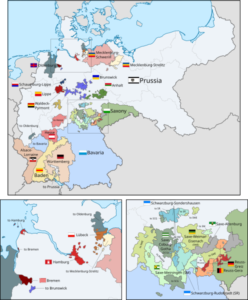
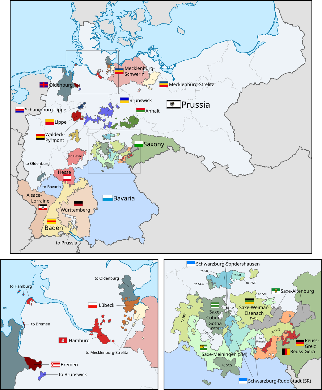
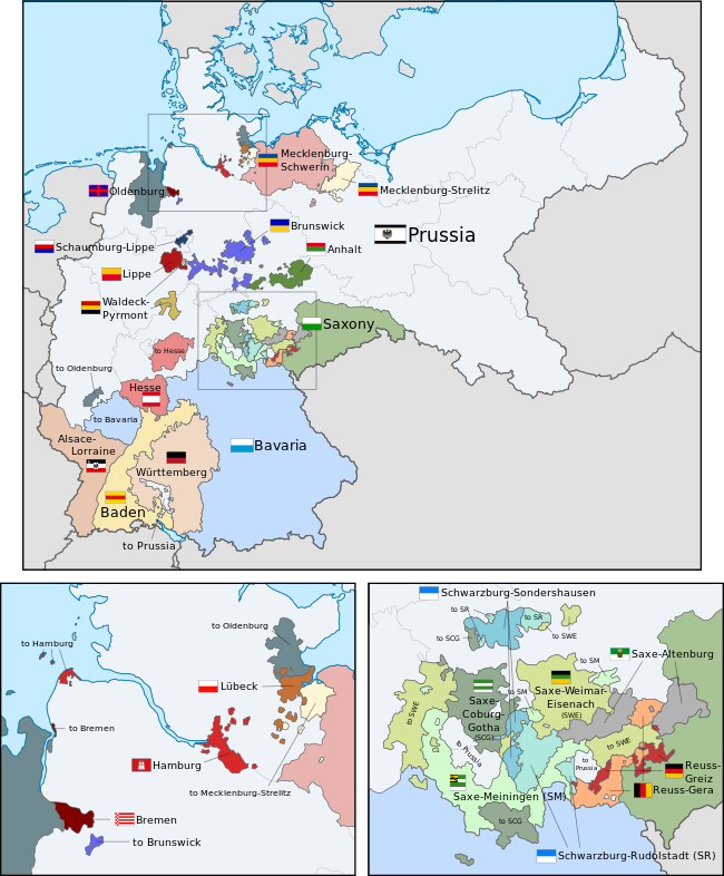
English: A map of the states of the German Empire, showing their location, flags and names in English. |
| Data | |
| Fonte |
Questo file deriva da: German Empire blank map.svg: Questa immagine vettoriale include elementi che sono stati presi o adattati da questa: Questa immagine vettoriale include elementi che sono stati presi o adattati da questa: Questa immagine vettoriale include elementi che sono stati presi o adattati da questa: Questa immagine vettoriale include elementi che sono stati presi o adattati da questa: Questa immagine vettoriale include elementi che sono stati presi o adattati da questa: Questa immagine vettoriale include elementi che sono stati presi o adattati da questa: Questa immagine vettoriale include elementi che sono stati presi o adattati da questa: Questa immagine vettoriale include elementi che sono stati presi o adattati da questa: Questa immagine vettoriale include elementi che sono stati presi o adattati da questa: Questa immagine vettoriale include elementi che sono stati presi o adattati da questa: Questa immagine vettoriale include elementi che sono stati presi o adattati da questa: Questa immagine vettoriale include elementi che sono stati presi o adattati da questa: Questa immagine vettoriale include elementi che sono stati presi o adattati da questa: Questa immagine vettoriale include elementi che sono stati presi o adattati da questa: Questa immagine vettoriale include elementi che sono stati presi o adattati da questa: Questa immagine vettoriale include elementi che sono stati presi o adattati da questa: Questa immagine vettoriale include elementi che sono stati presi o adattati da questa: Questa immagine vettoriale include elementi che sono stati presi o adattati da questa: Questa immagine vettoriale include elementi che sono stati presi o adattati da questa: Questa immagine vettoriale include elementi che sono stati presi o adattati da questa: Questa immagine vettoriale include elementi che sono stati presi o adattati da questa: Questa immagine vettoriale include elementi che sono stati presi o adattati da questa: Questa immagine vettoriale include elementi che sono stati presi o adattati da questa: Questa immagine include elementi che sono stati presi o adattati da questa: |
| Autore |
|
| Altre versioni |
|
| SVG sviluppo | Questa bandiera in grafica vettoriale è stata creata con un programma SVG ignoto. This flag uses embedded text that can be easily translated using a text editor. |


.svg)
.svg)
.svg)
.svg)
.svg)
.svg)
Licenza
Io, detentore del copyright su quest'opera, dichiaro di pubblicarla con la seguente licenza:
Questo file è disponibile in base alla licenza Creative Commons Attribuzione-Condividi allo stesso modo 3.0 Unported
- Tu sei libero:
- di condividere – di copiare, distribuire e trasmettere quest'opera
- di modificare – di adattare l'opera
- Alle seguenti condizioni:
- attribuzione – Devi fornire i crediti appropriati, un collegamento alla licenza e indicare se sono state apportate modifiche. Puoi farlo in qualsiasi modo ragionevole, ma non in alcun modo che suggerisca che il licenziante approvi te o il tuo uso.
- condividi allo stesso modo – Se remixi, trasformi o sviluppi il materiale, devi distribuire i tuoi contributi in base alla stessa licenza o compatibile all'originale.
Code for clickable map
Cronologia del file
Fare clic su un gruppo data/ora per vedere il file come si presentava nel momento indicato.
| Data/Ora | Miniatura | Dimensioni | Utente | Commento | |
|---|---|---|---|---|---|
| attuale | 16:04, 26 apr 2024 | | 1 042 × 1 260 (2,34 MB) | Heiliges | File uploaded using svgtranslate tool (https://svgtranslate.toolforge.org/). Added translation for ko. |
| 15:55, 26 apr 2024 |  | 1 042 × 1 260 (2,34 MB) | Heiliges | File uploaded using svgtranslate tool (https://svgtranslate.toolforge.org/). Added translation for ko. | |
| 15:47, 26 apr 2024 |  | 1 042 × 1 260 (2,32 MB) | Heiliges | File uploaded using svgtranslate tool (https://svgtranslate.toolforge.org/). Added translation for ko. | |
| 04:43, 24 feb 2019 |  | 1 042 × 1 260 (2,31 MB) | Alphathon | Corrected Brunswick territory accidentally given to Anhalt | |
| 16:55, 4 nov 2015 |  | 1 042 × 1 260 (2,39 MB) | Alphathon | Slight optimisation | |
| 03:33, 4 nov 2015 |  | 1 042 × 1 260 (2,39 MB) | Alphathon | Another minor tweak | |
| 03:31, 4 nov 2015 |  | 1 042 × 1 260 (2,39 MB) | Alphathon | Tweaked colours | |
| 00:25, 4 nov 2015 |  | 1 042 × 1 260 (2,39 MB) | Alphathon | Corrected typo | |
| 13:51, 3 nov 2015 |  | 1 042 × 1 260 (2,39 MB) | Alphathon | {{Information |Description={{en|A map of the states of the en:German Empire, showing their location, flags and names in English.}} |Source={{Derived from|File:German Empire blank map.svg|display=50}} {{AttribSVG|Flagge Herzogtum Anhalt.svg|David... |
Pagine che usano questo file
Le seguenti 2 pagine usano questo file:
Utilizzo globale del file
Anche i seguenti wiki usano questo file:
- Usato nelle seguenti pagine di ar.wikipedia.org:
- Usato nelle seguenti pagine di ast.wikipedia.org:
- Usato nelle seguenti pagine di az.wikipedia.org:
- Usato nelle seguenti pagine di ca.wikipedia.org:
- Usato nelle seguenti pagine di en.wikipedia.org:
- Usato nelle seguenti pagine di es.wikipedia.org:
- Usato nelle seguenti pagine di fi.wikipedia.org:
- Usato nelle seguenti pagine di he.wikipedia.org:
- Usato nelle seguenti pagine di hu.wikipedia.org:
- Usato nelle seguenti pagine di ko.wikipedia.org:
- Usato nelle seguenti pagine di nl.wikipedia.org:
- Usato nelle seguenti pagine di pt.wikipedia.org:
- Usato nelle seguenti pagine di sr.wikipedia.org:
- Usato nelle seguenti pagine di th.wikipedia.org:
- Usato nelle seguenti pagine di zh.wikipedia.org: