File:Iberian Peninsula at Night - NASA Earth Observatory.jpg

File originale (1 440 × 960 pixel, dimensione del file: 588 KB, tipo MIME: image/jpeg)
| Questo file e la sua pagina di descrizione (discussione · modifica) si trovano su Wikimedia Commons (?) |
Dettagli
| Descrizione |
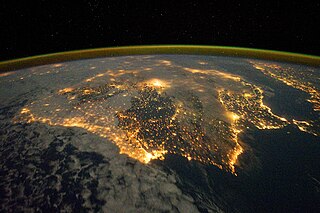
To download the full resolution and other files go to: earthobservatory.nasa.gov/IOTD/view.php?id=76777&src=... The city lights of Spain and Portugal define the Iberian Peninsula in this photograph from the International Space Station (ISS). Several large metropolitan areas are visible, marked by their relatively large and brightly lit areas, including the capital cities of Madrid, Spain—located near the center of the peninsula’s interior—and Lisbon, Portugal—located along the southwestern coastline. The ancient city of Seville, visible to the north of the Strait of Gibraltar, is one of the largest cities in Spain. The astronaut view is looking toward the east, and is part of a time-lapse series of images. The network of smaller cities and towns along the coastline and in the interior attest to the extent of the human presence on the Iberian landscape. The blurring of city lights is caused by thin cloud cover (image left and center), while cloud tops are dimly illuminated by moonlight. Though obscured, the lights of France are visible near the horizon line on the upper left, while the lights of northern Africa are more clearly discernable at right. The faint gold and green line of airglow—caused by ultraviolet radiation exciting the gas molecules in the upper atmosphere—parallels the horizon (or Earth limb). The Iberian Peninsula is the southwestern-most of the European peninsulas (together with the Italian and Balkan peninsulas), and includes the Principality of Andorra, as well as the Kingdom of Spain and the Portuguese Republic. The approximately 590,000 square kilometer landmass is bounded by the Atlantic Ocean to the northwest, west, and southwest and the Mediterranean Sea to the east. Its northeastern boundary is marked by the Pyrenees mountain range. Astronaut photograph ISS030-E-10008 was acquired on December 4, 2011, with a Nikon D3S digital camera using a 24 mm lens, and is provided by the ISS Crew Earth Observations experiment and Image Science & Analysis Laboratory, Johnson Space Center. The image was taken by the Expedition 30 crew. The image has been cropped and enhanced to improve contrast. Lens artifacts have been removed. The International Space Station Program supports the laboratory as part of the ISS National Lab to help astronauts take pictures of Earth that will be of the greatest value to scientists and the public, and to make those images freely available on the Internet. Additional images taken by astronauts and cosmonauts can be viewed at the NASA/JSC Gateway to Astronaut Photography of Earth. Caption by William L. Stefanov, Jacobs Technology/ESCG at NASA-JSC. The Earth Observatory's mission is to share with the public the images, stories, and discoveries about climate and the environment that emerge from NASA research, including its satellite missions, in-the-field research, and climate models. Like us on Facebook Follow us on Twitter Add us to your circles on Google+ |
| Data | |
| Fonte | Iberian Peninsula at Night |
| Autore | NASA's Earth Observatory |
| Luogo dello scatto | | Posizione di questa e altre immagini su: OpenStreetMap |
|---|
Licenza
- Tu sei libero:
- di condividere – di copiare, distribuire e trasmettere quest'opera
- di modificare – di adattare l'opera
- Alle seguenti condizioni:
- attribuzione – Devi fornire i crediti appropriati, un collegamento alla licenza e indicare se sono state apportate modifiche. Puoi farlo in qualsiasi modo ragionevole, ma non in alcun modo che suggerisca che il licenziante approvi te o il tuo uso.
| Questa immagine è stata originariamente caricata su Flickr da NASA Earth Observatory all'indirizzo https://www.flickr.com/photos/68824346@N02/6575192081. È stata controllata in data 2 luglio 2012 dal robot FlickreviewR ed è stato confermato il suo rilascio sotto i termini della licenza cc-by-2.0. |
Cronologia del file
Fare clic su un gruppo data/ora per vedere il file come si presentava nel momento indicato.
| Data/Ora | Miniatura | Dimensioni | Utente | Commento | |
|---|---|---|---|---|---|
| attuale | 15:36, 4 apr 2018 | | 1 440 × 960 (588 KB) | Triplecaña | higher res taken from https://earthobservatory.nasa.gov/IOTD/view.php?id=76777&src=flickr |
| 19:16, 2 lug 2012 |  | 720 × 480 (148 KB) | Dzlinker | == {{int:filedesc}} == {{Information |Description=To download the full resolution and other files go to: [http://earthobservatory.nasa.gov/IOTD/view.php?id=76777&src=flickr earthobservatory.nasa.gov/IOTD/view.php?id=76777&src=...] The city lights of S... |
Pagine che usano questo file
La seguente pagina usa questo file:
Utilizzo globale del file
Anche i seguenti wiki usano questo file:
- Usato nelle seguenti pagine di ca.wikipedia.org:
- Usato nelle seguenti pagine di en.wikipedia.org:
- Usato nelle seguenti pagine di es.wikipedia.org:
- Usato nelle seguenti pagine di sv.wikipedia.org:
- Usato nelle seguenti pagine di tl.wikipedia.org:
- Usato nelle seguenti pagine di ur.wikipedia.org: