File:Kuster Mill.JPG

Dimensioni di questa anteprima: 800 × 600 pixel. Altre risoluzioni: 320 × 240 pixel | 640 × 480 pixel | 1 024 × 768 pixel | 1 280 × 960 pixel | 2 560 × 1 920 pixel | 4 271 × 3 203 pixel.
File originale (4 271 × 3 203 pixel, dimensione del file: 4,48 MB, tipo MIME: image/jpeg)
| Questo file e la sua pagina di descrizione (discussione · modifica) si trovano su Wikimedia Commons (?) |
|
Questa è un'immagine di un luogo o edificio che è elencato nel National Register of Historic Places negli Stati Uniti. Il suo numero di riferimento è [https://npgallery.nps.gov/AssetDetail/NRIS/71000711
. 71000711
.]. |
Dettagli
| Descrizione |
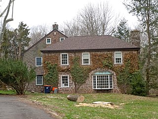
English: Kuster Mill on the NRHP since March 24, 1971. On Skippack Creek at Mill Road and Water Street Road, in Montgomery County, Pennsylvania south of Collegeville. A pedestrian bridge (now being repaired) leads into Evansburg State Park. Note that there is a Kuyster Mill in the park (on the other side of the creek to the west), but that this IS the Kuster Mill - it might also be called the Custer Mill because the family changed the spelling of the name. built in 1702, sold to Hermanus Custer in 1706, expanded by John Custer 1767. A later fulling mill was built, then burned down in 1936. It has been reconstructed and may be th part with the hipped roof shown in front here. |
| Data | |
| Fonte | Opera propria |
| Autore | Smallbones |
| Luogo dello scatto | | Posizione di questa e altre immagini su: OpenStreetMap |
|---|
Licenza
Io, detentore del copyright su quest'opera, dichiaro di pubblicarla con la seguente licenza:
| Questo file è reso disponibile nei termini della licenza Creative Commons CC0 1.0 Universal. | |
| La persona che ha associato un'opera con questo atto legale ha donato tale opera nel pubblico dominio rinunciando a tutti i diritti sull'opera in tutto il mondo, inclusi tutti i diritti connessi o altri diritti simili, per quanto permesso dalla legge. Puoi copiare, modificare, distribuire ed utilizzare l'opera, anche a fini commerciali, senza chiedere alcun permesso.
|
Cronologia del file
Fare clic su un gruppo data/ora per vedere il file come si presentava nel momento indicato.
| Data/Ora | Miniatura | Dimensioni | Utente | Commento | |
|---|---|---|---|---|---|
| attuale | 20:19, 8 apr 2011 | | 4 271 × 3 203 (4,48 MB) | Smallbones | {{Information |Description ={{en|1=Kuster Mill on the NRHP since March 24, 1971. On Skippack Creek at Mill Road and Water Street Road, in Montgomery County, Pennsylvania south of Collegeville. A pedestrian bridge (now being repaired) leads into Evansb |
Pagine che usano questo file
La seguente pagina usa questo file:
Utilizzo globale del file
Anche i seguenti wiki usano questo file:
- Usato nelle seguenti pagine di cy.wikipedia.org:
- Usato nelle seguenti pagine di en.wikipedia.org:
- Usato nelle seguenti pagine di en.wikivoyage.org:
- Usato nelle seguenti pagine di es.wikipedia.org:
- Usato nelle seguenti pagine di fr.wikipedia.org:
- Usato nelle seguenti pagine di simple.wikipedia.org:
- Usato nelle seguenti pagine di uk.wikipedia.org:
- Usato nelle seguenti pagine di vi.wikipedia.org:
- Usato nelle seguenti pagine di www.wikidata.org: