File:London1300-marking the spot of the future Marshalsea.png

London1300-marking_the_spot_of_the_future_Marshalsea.png (700 × 536 pixel, dimensione del file: 693 KB, tipo MIME: image/png)
| Questo file e la sua pagina di descrizione (discussione · modifica) si trovano su Wikimedia Commons (?) |
Dettagli
| Descrizione |
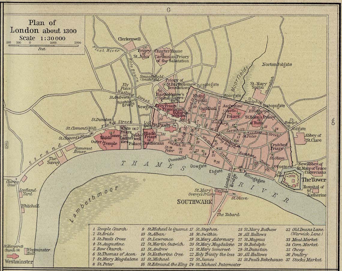
English: Source: Commons Image:London 1300 Historical Atlas William R Shepherd (died 1934).PNG
Description: A map of London in 1300 from a historical atlas by William R Shepherd. Apart from religious foundations and two or three other complexes, the city is confined within its walls, the bulk and heart of the City of London today. The City is flanked to the east and west by the royal fortress of the Tower of London and the royal palace of en:Bridewell. The route from the city to the royal centre of Westminster is not yet fully built up. There is a settlement at en:Southwark, but it is very small. The approximate location of the future Marshalsea prison (first mentioned 1370) is marked in blue. |
| Data | |
| Fonte | Shepherd, William R. Historical Atlas. New York, Henry Holt and Company, 1923. Direct JPG, Indirect HTML |
| Autore | Shepherd, William R. (d. 1934) |
| Licenza (Riusare questo file) |
This image is in the public domain due to its age. |
.PNG)
Licenza
|
Quest'opera è nel pubblico dominio anche in tutti i Paesi e nelle aree in cui la durata del copyright è la vita dell'autore più 70 anni o meno.
| |
| Questo file è stato identificato come libero da restrizioni conosciute riguardanti le leggi sul copyright, compresi tutti i diritti connessi e vicini. | |
Registro originale del caricamento
- 2007-12-23 05:07 SlimVirgin 700×536×8 (709283 bytes) {{PD-old}} Source: Commons [[:Image:London 1300 Historical Atlas William R Shepherd (died 1934).PNG]] Description: A map of London in 1300 from a historical atlas by William R Shepherd. Apart from religious foundations and two or three other complexes,
Cronologia del file
Fare clic su un gruppo data/ora per vedere il file come si presentava nel momento indicato.
| Data/Ora | Miniatura | Dimensioni | Utente | Commento | |
|---|---|---|---|---|---|
| attuale | 04:24, 7 giu 2008 | | 700 × 536 (693 KB) | File Upload Bot (Magnus Manske) | {{BotMoveToCommons|en.wikipedia}} {{Information |Description={{en|Source: Commons en::Image:London 1300 Historical Atlas William R Shepherd (died 1934).PNG Description: A map of London in 1300 from a historical atlas by William R Shepherd. Apart fr |
.PNG)
Pagine che usano questo file
La seguente pagina usa questo file:
Utilizzo globale del file
Anche i seguenti wiki usano questo file:
- Usato nelle seguenti pagine di es.wikipedia.org:
- Usato nelle seguenti pagine di no.wikipedia.org: