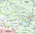
File:Map of Kharta region, east of Mount Everest.svg

File originale(file in formato SVG, dimensioni nominali 1 279 × 1 194 pixel, dimensione del file: 464 KB)

Logo di Commons
Logo di Commons
Questo file e la sua pagina di descrizione (discussione · modifica) si trovano su Wikimedia Commons (?)

Dettagli

Descrizione
English: Sketch map of w:Kharta and Kama velleys and environs, east of Mount Everest

The information on the map comes from File:Preliminary map of Mount Everest Expedition, 1921. Map I.jpg and
Reynolds, Kev (2011). "Trek 9, Kharta to the Kangshung Face". Everest : a trekker's guide : 9 treks in the Everest region, pp 234-235. Milnthorpe: Cicerone. ISBN 9781852846800. Retrieved 24 August 2014.
Howard-Bury, Charles; Mallory, George Leigh (1991). Keaney, Marian, ed. Everest Reconnaissance : The First Expedition of 1921, map "Approaches to Everest". London: Hodder & Stoughton. ISBN 0340556021.

plus information picked up in reading and web browsing. Villages and camps (red dots) are not distinguished and have not been included systematically. The Howard Bury book of the w:1921 British Mount Everest reconnaissance expedition mentions a number of villages in the lower Kharta Chu but does not name many of them. Glaciers are shown (schematically) roughly as they are at present. In 1921 they were larger – the Kangdushong Glacier went right across the Kama valley to the far side so blocking the progress of the Kangshung Glacier. Many place names have various romanisations and I have simply chosen one that seems appropriate. The red pecked line showing the routes taken in 1921 include routes taken by only some members of the expedition. However, routes taken by the surveyors have not been recorded. The green pecked line for present-day trekking is simply an example typical of what is being offered. Going to Samchung La (and on to Chog La) and back seems a shortish trek that some take.
Data
Fonte Opera propria
Autore Thincat

Licenza

Io, detentore del copyright su quest'opera, dichiaro di pubblicarla con la seguente licenza:
w:it:Creative Commons
attribuzione condividi allo stesso modo
Tu sei libero:
  • di condividere – di copiare, distribuire e trasmettere quest'opera
  • di modificare – di adattare l'opera
Alle seguenti condizioni:
  • attribuzione – Devi fornire i crediti appropriati, un collegamento alla licenza e indicare se sono state apportate modifiche. Puoi farlo in qualsiasi modo ragionevole, ma non in alcun modo che suggerisca che il licenziante approvi te o il tuo uso.
  • condividi allo stesso modo – Se remixi, trasformi o sviluppi il materiale, devi distribuire i tuoi contributi in base alla stessa licenza o compatibile all'originale.

Didascalie

Aggiungi una brevissima spiegazione di ciò che questo file rappresenta

Elementi ritratti in questo file

raffigura

Cronologia del file

Fare clic su un gruppo data/ora per vedere il file come si presentava nel momento indicato.

(ultima | prima) Vedi (10 più recenti | ) (10 | 20 | 50 | 100 | 250 | 500).
Data/OraMiniaturaDimensioniUtenteCommento
attuale21:31, 26 ago 2014Miniatura della versione delle 21:31, 26 ago 20141 279 × 1 194 (464 KB)Thincat1921 Everest reconnaissance routes and example trekking route shown
01:11, 26 ago 2014Miniatura della versione delle 01:11, 26 ago 20141 279 × 1 194 (451 KB)ThincatMinor additions and corrections
18:19, 25 ago 2014Miniatura della versione delle 18:19, 25 ago 20141 279 × 1 194 (422 KB)ThincatLumeh, Kangchungtse (Makalu II), ...
12:18, 25 ago 2014Miniatura della versione delle 12:18, 25 ago 20141 279 × 1 194 (420 KB)ThincatExtended north
01:51, 25 ago 2014Miniatura della versione delle 01:51, 25 ago 20141 280 × 718 (105 KB)ThincatLes violent colours
01:30, 25 ago 2014Miniatura della versione delle 01:30, 25 ago 20141 280 × 718 (105 KB)ThincatAdd Rongbuk Glacier, etc.
00:45, 25 ago 2014Miniatura della versione delle 00:45, 25 ago 20141 280 × 718 (102 KB)ThincatMore tidying
22:08, 24 ago 2014Miniatura della versione delle 22:08, 24 ago 20141 213 × 713 (93 KB)ThincatSlight tidy
21:30, 24 ago 2014Miniatura della versione delle 21:30, 24 ago 20141 213 × 713 (89 KB)ThincatCrop
21:25, 24 ago 2014Miniatura della versione delle 21:25, 24 ago 20141 231 × 844 (87 KB)ThincatVarious. Continuing Kharta Chu, etc
(ultima | prima) Vedi (10 più recenti | ) (10 | 20 | 50 | 100 | 250 | 500).

La seguente pagina usa questo file:

Utilizzo globale del file

Anche i seguenti wiki usano questo file:

Metadati