File:PAR Scope.jpg
File originale (1 900 × 2 800 pixel, dimensione del file: 1,36 MB, tipo MIME: image/jpeg)
| Questo file e la sua pagina di descrizione (discussione · modifica) si trovano su Wikimedia Commons (?) |
| Descrizione |
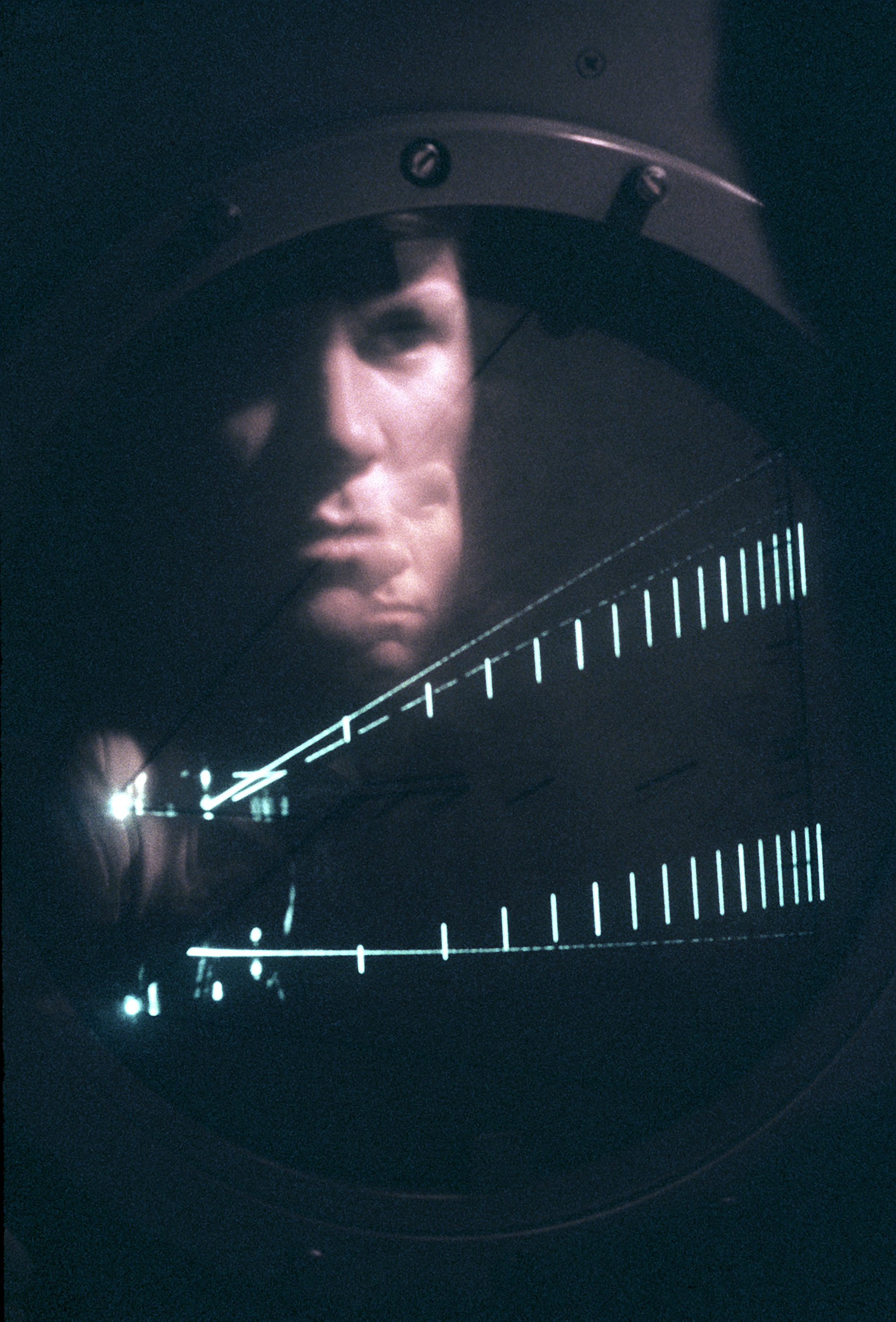
SRA James Calkins, an air traffic controller with the 1974th Communications Group of the Air Force Communications Command (AFCC), is reflected in the precision approach radar scope as he directs an aircraft. Location: SCOTT AIR FORCE BASE, ILLINOIS (IL) UNITED STATES OF AMERICA (USA) |
|||
| Data | Scattata il 1 novembre 1980 | |||
| Fonte | ID:DFST8203799 | |||
| Autore | Service Depicted: Air Force | |||
| Licenza (Riusare questo file) |
|

description
From: w:en:Radar_display#Beta_Scan_Scope
The specialist Beta Scan Scope was used for precision approach radar systems. It displays two lines on the same display, the upper one (typically) displaying the vertical approach (the glideslope), and the lower one the horizontal approach. A marker indicates the desired touchdown point on the runway, and often the lines are angled towards the middle of the screen to indicate this location. A single aircraft's "blip" is also displayed, superimposed over both lines, the signals being generated from separate antennas. Deviation from the centerline of the approach can be seen and easily relayed to the pilot.
In the image, the upper portion of the display shows the vertical situation, and the lower portion the horizontal. In the vertical, the two diagonal lines show the desired glideslope (upper) and minimum altitude approach (lower). The aircraft began its approach below the glideslope and captured it just before landing. The proper landing point is shown by the horizontal line at the left end. The lower display shows the aircraft starting to the left of the approach line and then being guided toward it.
Cronologia del file
Fare clic su un gruppo data/ora per vedere il file come si presentava nel momento indicato.
| Data/Ora | Miniatura | Dimensioni | Utente | Commento | |
|---|---|---|---|---|---|
| attuale | 02:03, 20 lug 2006 | | 1 900 × 2 800 (1,36 MB) | Dual Freq | {{Information |Source=[http://www.dodmedia.osd.mil/Assets/1982/Air_Force/DF-ST-82-03799.JPEG ID:DFST8203799] |Author=Service Depicted: Air Force |Description=SRA James Calkins, an air traffic controller with the 1974th Communications Group of the Air |
Pagine che usano questo file
La seguente pagina usa questo file:
Utilizzo globale del file
Anche i seguenti wiki usano questo file:
- Usato nelle seguenti pagine di en.wikipedia.org:
- Usato nelle seguenti pagine di es.wikipedia.org:
- Usato nelle seguenti pagine di fr.wikipedia.org:
- Usato nelle seguenti pagine di sv.wikipedia.org:
- Usato nelle seguenti pagine di www.wikidata.org: