File:Rock of Cashel, Tipperary.jpg
Dimensioni di questa anteprima: 800 × 514 pixel. Altre risoluzioni: 320 × 206 pixel | 640 × 411 pixel | 1 024 × 658 pixel.
File originale (1 024 × 658 pixel, dimensione del file: 826 KB, tipo MIME: image/jpeg)
| Questo file e la sua pagina di descrizione (discussione · modifica) si trovano su Wikimedia Commons (?) |
| Descrizione |
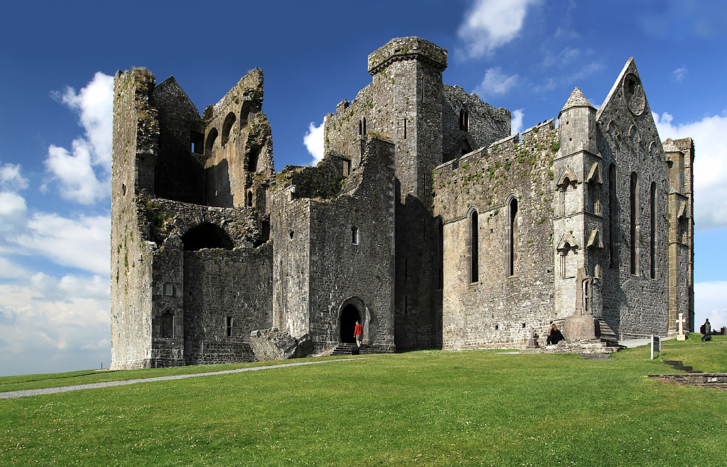
English: Rock of Cashel, Tipperary, Munster, Ireland.
The view is of the cathedral and its attached castle on the Rock of Cashel. From the earliest of times, and before these buildings were erected, what is now the cathedral close was always a fortress. It was then the seat of Brian Boru, crowned High King of Ireland in 977, but in 1101 it was handed over to the church by Muircheartach O'Brien. Violence erupted on the Rock in 1647 when the Rock of Cashel was stormed by Lord Inchiquin's forces. During the conflict twenty clerics who had taken refuge there were killed within the castle, as were all the Irish Confederate troops. |
| Data | |
| Fonte | see below |
| Autore | Mike Searle |
| Licenza (Riusare questo file) |
Creative Commons Attribution Share-alike license 2.0 |
| Attribuzione (richiesto dalla licenza) | Mike Searle / Castles of Munster: Cashel, Rock of Cashel, Tipperary / |
| Luogo dello scatto | | Posizione di questa e altre immagini su: OpenStreetMap |
|---|
_&language=it)
| Posizione del soggetto | | Posizione di questa e altre immagini su: OpenStreetMap |
|---|
_&language=it)
Licenza

|
Questa immagine proviene dalla collezione del progetto Geograph. Vedi questa fotografia sul sito web di Geograph per visualizzare i dettagli relativi al fotografo. Il copyright di questa immagine appartiene a Mike Searle ed è pubblicata secondo i termini della licenza Creative Commons Attribuzione-Condividi allo stesso modo 2.0.
|
Questo file è disponibile in base alla licenza Creative Commons Attribuzione-Condividi allo stesso modo 2.0 Generico
Attribuzione: Mike Searle
- Tu sei libero:
- di condividere – di copiare, distribuire e trasmettere quest'opera
- di modificare – di adattare l'opera
- Alle seguenti condizioni:
- attribuzione – Devi fornire i crediti appropriati, un collegamento alla licenza e indicare se sono state apportate modifiche. Puoi farlo in qualsiasi modo ragionevole, ma non in alcun modo che suggerisca che il licenziante approvi te o il tuo uso.
- condividi allo stesso modo – Se remixi, trasformi o sviluppi il materiale, devi distribuire i tuoi contributi in base alla stessa licenza o compatibile all'originale.
Cronologia del file
Fare clic su un gruppo data/ora per vedere il file come si presentava nel momento indicato.
| Data/Ora | Miniatura | Dimensioni | Utente | Commento | |
|---|---|---|---|---|---|
| attuale | 20:31, 10 feb 2019 | | 1 024 × 658 (826 KB) | Geograph Update Bot | Higher-resolution version from Geograph. |
| 19:17, 18 ott 2009 |  | 640 × 411 (315 KB) | Thomas Gun | {{Information |Description={{en|1=Rock of Cashel, Tipperary, Munster, Ireland.}} |Source=[http://www.geograph.org.uk/photo/1393486 geography.org.uk] |Date=Friday, 26 June, 2009 |Author=[http://www.geograph.org.uk/profile/10423 Mike Searle] |Permission=Cre |
Pagine che usano questo file
Le seguenti 2 pagine usano questo file:
Utilizzo globale del file
Anche i seguenti wiki usano questo file:
- Usato nelle seguenti pagine di cs.wikipedia.org:
- Usato nelle seguenti pagine di de.wikipedia.org:
- Usato nelle seguenti pagine di de.wikivoyage.org:
- Usato nelle seguenti pagine di en.wikipedia.org:
- Usato nelle seguenti pagine di en.wikivoyage.org:
- Usato nelle seguenti pagine di eo.wikipedia.org:
- Usato nelle seguenti pagine di es.wikipedia.org:
- Usato nelle seguenti pagine di eu.wikipedia.org:
- Usato nelle seguenti pagine di fa.wikipedia.org:
- Usato nelle seguenti pagine di ga.wikipedia.org:
- Usato nelle seguenti pagine di he.wikipedia.org:
- Usato nelle seguenti pagine di it.wikivoyage.org:
- Usato nelle seguenti pagine di ja.wikivoyage.org:
- Usato nelle seguenti pagine di nl.wikipedia.org:
- Usato nelle seguenti pagine di no.wikipedia.org:
- Usato nelle seguenti pagine di uk.wikipedia.org:
- Usato nelle seguenti pagine di www.wikidata.org: