File:Safe trail map NPS1962.jpg

Dimensioni di questa anteprima: 800 × 532 pixel. Altre risoluzioni: 320 × 213 pixel | 640 × 426 pixel | 900 × 599 pixel.
File originale (900 × 599 pixel, dimensione del file: 48 KB, tipo MIME: image/jpeg)
| Questo file e la sua pagina di descrizione (discussione · modifica) si trovano su Wikimedia Commons (?) |
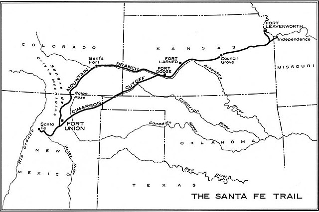
| Descrizione | Map of the historic Santa Fe Trail in the southwestern United States as around 1860 | |||
| Data | ||||
| Fonte | http://www.cr.nps.gov/history/online_books/hh/35/images/hh35b1.jpg - from Robert M. Utley, FORT UNION - National Monument - New Mexico, National Park Service, Historical Handbook Series No. 35, Washington, D.C., 1962 | |||
| Autore | NPS Graphics | |||
| Licenza (Riusare questo file) |
|
Cronologia del file
Fare clic su un gruppo data/ora per vedere il file come si presentava nel momento indicato.
| Data/Ora | Miniatura | Dimensioni | Utente | Commento | |
|---|---|---|---|---|---|
| attuale | 10:38, 20 ott 2006 | | 900 × 599 (48 KB) | H-stt | {{Information |Description= Map of the historic ''Santa Fe Trail'' in the southwestern United States as around 1860 |Source= http://www.cr.nps.gov/history/online_books/hh/35/images/hh35b1.jpg - from Robert M. Utley, ''FORT UNION - National Monument - New |
Pagine che usano questo file
Le seguenti 2 pagine usano questo file:
Utilizzo globale del file
Anche i seguenti wiki usano questo file:
- Usato nelle seguenti pagine di de.wikipedia.org:
- Usato nelle seguenti pagine di en.wikipedia.org:
- Usato nelle seguenti pagine di es.wikipedia.org:
- Usato nelle seguenti pagine di fa.wikipedia.org:
- Usato nelle seguenti pagine di no.wikipedia.org:
- Usato nelle seguenti pagine di sr.wikipedia.org:
- Usato nelle seguenti pagine di sv.wikipedia.org:
- Usato nelle seguenti pagine di www.wikidata.org: