File:Satellite Image of Earth's Interrelated Systems and Climate - GPN-2002-000121.jpg

Dimensioni di questa anteprima: 600 × 600 pixel. Altre risoluzioni: 240 × 240 pixel | 480 × 480 pixel | 768 × 768 pixel | 1 024 × 1 024 pixel | 2 350 × 2 350 pixel.
File originale (2 350 × 2 350 pixel, dimensione del file: 1,28 MB, tipo MIME: image/jpeg)
| Questo file e la sua pagina di descrizione (discussione · modifica) si trovano su Wikimedia Commons (?) |
| Descrizione |
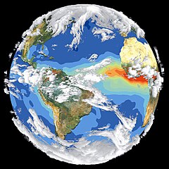
English: Satellite data and images such as those presented in this image of Earth give scientists a more comprehensive view of the Earth's interrelated systems and climate. Four different satellites contributed to the making of this image. Sea-viewing Wide Field-of-view Sensor (SeaWiFS) provided the land image layer and is a true color composite of land vegetation for cloud-free conditions from September 18 to October 3, 1997. Each red dot over South America and Africa represents a fire detected by the Advanced Very High Resolution Radiometer. The oceanic aerosol layer is based on National Oceanic and Atmospheric Administration (NOAA) data and is caused by biomass burning and windblown dust over Africa. The cloud layer is a composite of infrared images from four geostationary weather satellites?NOAA's GOES 8 and 9, the European Space Agency's METEOSAT, and Japan's GMS 5. |
|||||
| Data | ||||||
| Fonte | Great Images in NASA Description | |||||
| Autore | NASA | |||||
| Licenza (Riusare questo file) |
|

Questa immagine o filmato è stato catalogato dal Goddard Space Flight Center della National Aeronautics and Space Administration (NASA) degli Stati Uniti d'Americacon il Photo ID: GPN-2002-000121 ET Alternate ID: 119.Questo tag non indica lo status del copyright dell'opera ad esso associato. È quindi richiesto un normale tag di copyright. Vedi Commons:Licenze per maggiori informazioni. Altre lingue:
|
Cronologia del file
Fare clic su un gruppo data/ora per vedere il file come si presentava nel momento indicato.
| Data/Ora | Miniatura | Dimensioni | Utente | Commento | |
|---|---|---|---|---|---|
| attuale | 09:50, 14 apr 2015 | | 2 350 × 2 350 (1,28 MB) | Jcpag2012 | cropped from black borders |
| 00:54, 10 apr 2009 |  | 2 700 × 3 214 (2,91 MB) | BotMultichillT | {{Information |Description={{en|1=Satellite data and images such as those presented in this image of Earth give scientists a more comprehensive view of the Earth's interrelated systems and climate. Four different satellites contributed to the making of th |
Pagine che usano questo file
La seguente pagina usa questo file:
Utilizzo globale del file
Anche i seguenti wiki usano questo file:
- Usato nelle seguenti pagine di ar.wikipedia.org:
- Usato nelle seguenti pagine di de.wikipedia.org:
- Usato nelle seguenti pagine di el.wikipedia.org:
- Usato nelle seguenti pagine di en.wikipedia.org:
- Usato nelle seguenti pagine di no.wikipedia.org: