File:SomersetSouth.png
Non sono disponibili versioni a risoluzione più elevata.
SomersetSouth.png (200 × 101 pixel, dimensione del file: 6 KB, tipo MIME: image/png)
| Questo file e la sua pagina di descrizione (discussione · modifica) si trovano su Wikimedia Commons (?) |
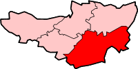
South Somerset district in Somerset
Created by en:User:Morwen

|
È permesso copiare, distribuire e/o modificare questo documento in base ai termini della GNU Free Documentation License, Versione 1.2 o successive pubblicata dalla Free Software Foundation; senza alcuna sezione non modificabile, senza testo di copertina e senza testo di quarta di copertina. Una copia della licenza è inclusa nella sezione intitolata Testo della GNU Free Documentation License. |
| Questo file è disponibile in base alla licenza Creative Commons Attribuzione-Condividi allo stesso modo 3.0 Unported | ||
| ||
| Questo tag di copyright è stato aggiunto nell'ambito dell'aggiornamento della licenza dei progetti Wikimedia. |
Cronologia del file
Fare clic su un gruppo data/ora per vedere il file come si presentava nel momento indicato.
| Data/Ora | Miniatura | Dimensioni | Utente | Commento | |
|---|---|---|---|---|---|
| attuale | 15:58, 8 feb 2010 | | 200 × 101 (6 KB) | Mahahahaneapneap | Transparent background |
| 17:11, 24 mag 2006 |  | 200 × 101 (10 KB) | Nichtbesserwisser | South Somerset district in Somerset Created by en:User:Morwen {{GFDL}} Category:Maps of districts in South West England |
Pagine che usano questo file
Nessuna pagina utilizza questo file.
Utilizzo globale del file
Anche i seguenti wiki usano questo file:
- Usato nelle seguenti pagine di bg.wikipedia.org:
- Usato nelle seguenti pagine di de.wikipedia.org:
- Usato nelle seguenti pagine di en.wikipedia.org:
- Yeovil
- Ilminster
- Ilchester
- South Somerset
- Somerton, Somerset
- Chard, Somerset
- South Cadbury
- East Coker
- Castle Cary
- Crewkerne
- Yeovilton
- Merriott
- Montacute
- Martock
- Ashill, Somerset
- Wincanton
- Abbas Combe
- Templecombe
- Aller, Somerset
- Barton St David
- Langport
- Chiselborough
- Dowlish Wake
- Alford, Somerset
- Ansford
- Ash, South Somerset
- Babcary
- Barrington, Somerset
- Barwick, Somerset
- Beercrocombe
- Bratton Seymour
- Brewham
- Broadway, Somerset
- Bruton
- Brympton
- Buckland St Mary
- Chaffcombe
- Charlton Horethorne
- Charlton Mackrell
- Charlton Musgrove
- Chillington, Somerset
- Chilthorne Domer
- Chilton Cantelo
- Closworth
- Combe St Nicholas
- Compton Dundon
- Compton Pauncefoot
Visualizza l'utilizzo globale di questo file.