File:US humid subtropical.png

Dimensioni di questa anteprima: 800 × 552 pixel. Altre risoluzioni: 320 × 221 pixel | 640 × 441 pixel | 841 × 580 pixel.
File originale (841 × 580 pixel, dimensione del file: 15 KB, tipo MIME: image/png)
| Questo file e la sua pagina di descrizione (discussione · modifica) si trovano su Wikimedia Commons (?) |
Dettagli
| Descrizione |
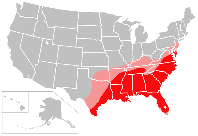
English: The red shading on this map denotes areas of the United States with a solidly humid subtropical climate; the pink shading denotes areas of the United States with a transitional/borderline humid subtropical climate.
I created this map based largely on the information contained in the Humid subtropical climate article, with supplemental information gleaned from articles about various US cities and states. Consider this to be a work in progress and feel free to suggest changes/corrections to me or make them yourself, if necessary. Points of clarification:
|
| Data | 6 gennaio 2007 (data di caricamento originaria) |
| Fonte | Created by user:Caliga10 |
| Autore | Caliga10 di Wikipedia in inglese |
Licenza
Caliga10 da en.wikipedia.org, detentore del copyright su quest'opera, dichiara di pubblicarla con la seguente licenza:
| Questo file è disponibile in base alla licenza Creative Commons Attribuzione-Condividi allo stesso modo 3.0 Unported Soggetto a disclaimer. | ||
| Attribuzione: Caliga10 da en.wikipedia.org | ||
| ||
| Questo tag di copyright è stato aggiunto nell'ambito dell'aggiornamento della licenza dei progetti Wikimedia. |

|
È permesso copiare, distribuire e/o modificare questo documento in base ai termini della GNU Free Documentation License, Versione 1.2 o successive pubblicata dalla Free Software Foundation; senza alcuna sezione non modificabile, senza testo di copertina e senza testo di quarta di copertina. Una copia della licenza è inclusa nella sezione intitolata Testo della GNU Free Documentation License. Soggetto a disclaimer. |
Registro originale del caricamento
La pagina di descrizione originale era qui. Tutti i nomi utente che seguono sono riferiti a en.wikipedia.
- 2007-02-13 04:18 Caliga10 841×580× (15462 bytes) Updated version of this map, based on input from [[user:CrazyC83|CrazyC83]]. The following changes have been made: South Florida (except the Florida Keys) is shaded as a transitional zone (to a full tropical climate; the Keys remain unshaded since they
- 2007-01-06 23:25 Caliga10 841×580× (15505 bytes) Created by [[user:Caliga10]] I created this map based largely on the information contained in the [[Humid subtropical climate]] article, with supplemental information gleaned from articles about various US cities and states. Consider this to be a work in
Cronologia del file
Fare clic su un gruppo data/ora per vedere il file come si presentava nel momento indicato.
| Data/Ora | Miniatura | Dimensioni | Utente | Commento | |
|---|---|---|---|---|---|
| attuale | 07:56, 27 lug 2013 | | 841 × 580 (15 KB) | OgreBot | (BOT): Uploading old version of file from en.wikipedia; originally uploaded on 2007-02-13 04:18:41 by Caliga10 |
| 07:56, 27 lug 2013 |  | 841 × 580 (15 KB) | OgreBot | (BOT): Uploading old version of file from en.wikipedia; originally uploaded on 2007-01-06 23:25:26 by Caliga10 | |
| 11:44, 25 lug 2013 |  | 800 × 552 (104 KB) | Encore007 | User created page with UploadWizard |
Pagine che usano questo file
La seguente pagina usa questo file:
Utilizzo globale del file
Anche i seguenti wiki usano questo file:
- Usato nelle seguenti pagine di ar.wikipedia.org:
- Usato nelle seguenti pagine di en.wikipedia.org:
- Usato nelle seguenti pagine di ja.wikipedia.org:
- Usato nelle seguenti pagine di no.wikipedia.org:
- Usato nelle seguenti pagine di zh.wikipedia.org: