Alemanni_expansion.png(566 × 499 pixel, dimensione del file: 449 KB, tipo MIME: image/png)

Logo di Commons
Logo di Commons
Questo file e la sua pagina di descrizione (discussione · modifica) si trovano su Wikimedia Commons (?)

Dettagli

Descrizione

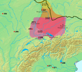
Siedlungsgebiet und Schlachten der Alemannen, 3.-6. Jh. Gepunktet ist der Germanische Limes wie er bis 260 bestand. Die Alemannen werden erstmals im 3. Jh. als am Main siedelnd erwähnt (von Cassius Dio im Zusammenhang mit einem Feldzug von 213). Bis um 280 breitete sich das Siedlungsgebiet nach Süden aus. Ab dem 4. Jh. wurden die Alemannen durch die Franken nach Süden gedrängt, so dass ehemaliges Siedlungsgebiet im Norden nun nicht mehr von Alemannen bewohnt war. Im 3. und 4. Jh. waren Alemannische Kriegerscharen in Gallien unterwegs und wurden wiederholt von der römischen Armee zurückgeschlagen, aber permanent von Alemannen besiedeltes Gebiet befand sich noch ausschliesslich rechtsrheinisch. 406 überschritten die Alemannen den Rhein und besiedelten das Elsass und später auch das Schweizer Mittelland und die Region rund um den Bodensee. Bis im 8. Jh. war das Gebiet der heutigen Deutschschweiz weitgehend Alemannisch (abgesehen von den alpinen (Höchstalemannischen) Gebieten, die im Hochmittelalter noch durch die Walserwanderung erreicht wurden). Kleine Jahreszahlen:

  • 268 Schlacht am Lacus Benacus
  • 271 Alamannen fallen in Oberitalien ein und Schlacht bei Fano
  • 298 (west) Schlacht bei Langres
  • 298 (ost) Schlacht von Vindonissa
  • 356 Juthungen fallen in die Provinz Raetia ein
  • 357 Schlacht von Argentoratum
  • 378 Schlacht bei Argentovaria ---- Regiones de asentamiento de los Alamanes y lugares fechados de sus enfrentamientos contra los romanos. Línea negra = limes.
Fonte http://www.rhetorik-netz.de/rhetorik/alemann.htm copia archiviata at the Wayback Machine, wo wiederum Kartenmaterial aus dem Klett Sprachbuch A/B 10 (1975, ISBN 3123260003) gezeigt wird.
Licenza
(Riusare questo file)
Io, detentore del copyright su quest'opera, dichiaro di pubblicarla con la seguente licenza:
GNU head È permesso copiare, distribuire e/o modificare questo documento in base ai termini della GNU Free Documentation License, Versione 1.2 o successive pubblicata dalla Free Software Foundation; senza alcuna sezione non modificabile, senza testo di copertina e senza testo di quarta di copertina. Una copia della licenza è inclusa nella sezione intitolata Testo della GNU Free Documentation License.
w:it:Creative Commons
attribuzione condividi allo stesso modo
Questo file è disponibile in base alla licenza Creative Commons Attribuzione-Condividi allo stesso modo 3.0 Unported
Tu sei libero:
  • di condividere – di copiare, distribuire e trasmettere quest'opera
  • di modificare – di adattare l'opera
Alle seguenti condizioni:
  • attribuzione – Devi fornire i crediti appropriati, un collegamento alla licenza e indicare se sono state apportate modifiche. Puoi farlo in qualsiasi modo ragionevole, ma non in alcun modo che suggerisca che il licenziante approvi te o il tuo uso.
  • condividi allo stesso modo – Se remixi, trasformi o sviluppi il materiale, devi distribuire i tuoi contributi in base alla stessa licenza o compatibile all'originale.
Questo tag di copyright è stato aggiunto nell'ambito dell'aggiornamento della licenza dei progetti Wikimedia.
Public domain
This image is in the public domain because it came from the site https://www.demis.nl/products/web-map-server/examples/ and was released by the copyright holder. Permission is granted to copy, distribute and/or modify this map since it is based on free of copyright images from: www.demis.nl. See also approval email on de.wp and its clarification.

Deutsch | English | македонски | മലയാളം | Nederlands | slovenščina | +/−

Public domain This work has been released into the public domain by its copyright holder, www.demis.nl. This applies worldwide.
In alcuni paesi questo potrebbe non essere legalmente possibile. In tal caso:
www.demis.nl garantisce a chiunque il diritto di utilizzare quest'opera per qualsiasi scopo, senza alcuna condizione, a meno che tali condizioni siano richieste dalla legge.

 Geotemporal data
Bounding box
N: 50.3347813°N
W: 3.6714225°E E: 13.0454169°E
S: 44.6987939°N
Georeferencing View the georeferenced map in the Wikimaps Warper

Didascalie

Aggiungi una brevissima spiegazione di ciò che questo file rappresenta
Area of settlement and battles of Alemanni against Romans, 3rd to 6th cent. A.D. (dotted line: limes until 260)

Elementi ritratti in questo file

raffigura

image/png

9906d577e0095aac0c14ef275d869cd93200950a

460 166 byte

499 pixel

566 pixel

Cronologia del file

Fare clic su un gruppo data/ora per vedere il file come si presentava nel momento indicato.

Data/OraMiniaturaDimensioniUtenteCommento
attuale13:47, 19 apr 2023Miniatura della versione delle 13:47, 19 apr 2023566 × 499 (449 KB)Artoria2e5river names -- might make it easier to read
14:30, 29 mar 2008Miniatura della versione delle 14:30, 29 mar 2008566 × 499 (404 KB)Alexander.stohrupdate of prior works, prior authors claimed rights might apply. adjusted location of Moguntiacum. Its just raw pixel works, no source or even map layers were available to do this. The mountains in the previousely covered areas are just sprayed - so dont
21:29, 24 mag 2006Miniatura della versione delle 21:29, 24 mag 2006566 × 499 (399 KB)Dbachmannupdate
22:55, 23 mag 2006Miniatura della versione delle 22:55, 23 mag 2006450 × 437 (286 KB)Dbachmann{{GFDL-self}} historical distribution of the Alemanni. work in progress {{GFDL-self}} based on [http://www.rhetorik-netz.de/rhetorik/alemann.htm]

Utilizzo globale del file

Anche i seguenti wiki usano questo file:

Visualizza l'utilizzo globale di questo file.

Metadati