File:Bog Asphodel - geograph.org.uk - 1402752.jpg
Bog_Asphodel_-_geograph.org.uk_-_1402752.jpg (640 × 480 pixel, dimensione del file: 118 KB, tipo MIME: image/jpeg)
| Questo file e la sua pagina di descrizione (discussione · modifica) si trovano su Wikimedia Commons (?) |
Dettagli
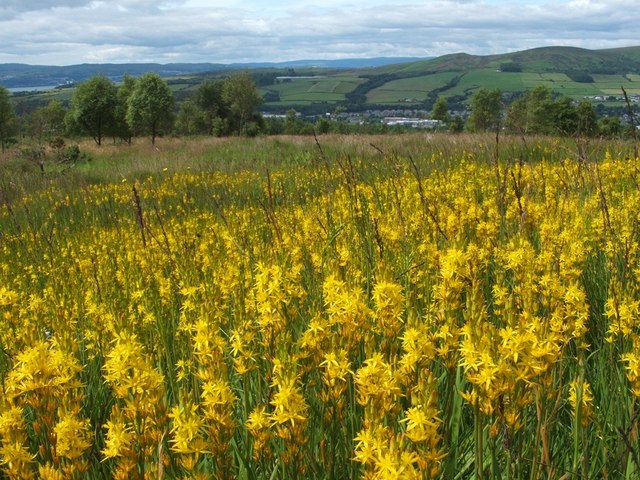
| Descrizione |
English: Bog Asphodel This is a closer view of some of the flowers that make up an extensive patch of Bog Asphodel (Narthecium ossifragum) on the grassy moors below Pappert Hill: 1402750.
This is a native species, found in bogs and other wet acidic habitats. After flowering, the dried-up remnants of the plant retain a strong orange-yellow colouring for quite some time. The specific name 'ossifragum' means 'bone-breaker'; as is explained in Richard Mabey's "Flora Britannica", that name is indirectly related to the habitat in which the plant is found: "it derives from the belief that grazing the plant made the bones of sheep brittle – though it was not bog asphodel which caused this, but the sour calcium-poor pastures in which it occurs". As for the background, a small part of the River Clyde can be seen at the far left. Slightly to the left of centre, visible as little more than a thin pale-blue line near the top of a hill, is Carman Reservoir. The hills to the right of centre are Carman Hill and Overton Muir. |
| Data | |
| Fonte | From geograph.org.uk |
| Autore | Lairich Rig |
| Attribuzione (richiesto dalla licenza) | Lairich Rig / Bog Asphodel / |
| Luogo dello scatto | | Posizione di questa e altre immagini su: OpenStreetMap |
|---|
_heading:247.00&language=it)
| Posizione del soggetto | | Posizione di questa e altre immagini su: OpenStreetMap |
|---|
_heading:247.00&language=it)
Licenza

|
Questa immagine proviene dalla collezione del progetto Geograph. Vedi questa fotografia sul sito web di Geograph per visualizzare i dettagli relativi al fotografo. Il copyright di questa immagine appartiene a Lairich Rig ed è pubblicata secondo i termini della licenza Creative Commons Attribuzione-Condividi allo stesso modo 2.0.
|
- Tu sei libero:
- di condividere – di copiare, distribuire e trasmettere quest'opera
- di modificare – di adattare l'opera
- Alle seguenti condizioni:
- attribuzione – Devi fornire i crediti appropriati, un collegamento alla licenza e indicare se sono state apportate modifiche. Puoi farlo in qualsiasi modo ragionevole, ma non in alcun modo che suggerisca che il licenziante approvi te o il tuo uso.
- condividi allo stesso modo – Se remixi, trasformi o sviluppi il materiale, devi distribuire i tuoi contributi in base alla stessa licenza o compatibile all'originale.
Cronologia del file
Fare clic su un gruppo data/ora per vedere il file come si presentava nel momento indicato.
| Data/Ora | Miniatura | Dimensioni | Utente | Commento | |
|---|---|---|---|---|---|
| attuale | 13:49, 1 mar 2011 | | 640 × 480 (118 KB) | GeographBot | == {{int:filedesc}} == {{Information |description={{en|1=Bog Asphodel This is a closer view of some of the flowers that make up an extensive patch of Bog Asphodel (Narthecium ossifragum) on the grassy moors below Pappert Hill: 1402750. This is a na |
Pagine che usano questo file
La seguente pagina usa questo file:
Utilizzo globale del file
Anche i seguenti wiki usano questo file:
- Usato nelle seguenti pagine di be.wikipedia.org:
- Usato nelle seguenti pagine di cs.wikipedia.org:
- Usato nelle seguenti pagine di en.wikipedia.org:
- Usato nelle seguenti pagine di fr.wikivoyage.org:
- Usato nelle seguenti pagine di id.wikipedia.org:
- Usato nelle seguenti pagine di nn.wikipedia.org:
- Usato nelle seguenti pagine di uk.wikipedia.org:
- Usato nelle seguenti pagine di vi.wikipedia.org: