File:Castles old and new - geograph.org.uk - 163364.jpg
Dimensioni di questa anteprima: 450 × 600 pixel. Altre risoluzioni: 180 × 240 pixel | 480 × 640 pixel.
File originale (480 × 640 pixel, dimensione del file: 101 KB, tipo MIME: image/jpeg)
| Questo file e la sua pagina di descrizione (discussione · modifica) si trovano su Wikimedia Commons (?) |
Dettagli
| Descrizione |
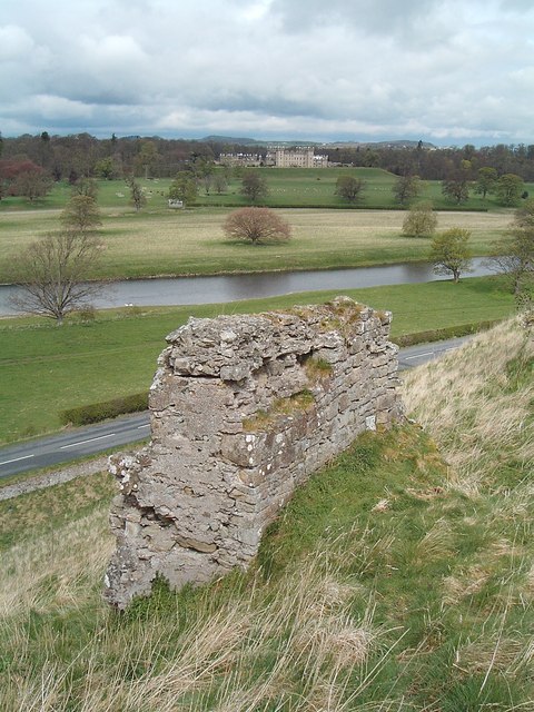
English: Castles old and new. High on its earthworks on a narrow isthmus between the Tweed and Teviot rivers, Roxburgh Castle (foreground) had strong claims in medieval times to impregnability. Not so! The castle changed hands between the Scots and English no fewer than 10 times in the border wars of the 15th and 16th centuries. Now only a few walls remain of this sometime seat of the Scottish king David 1. Across the Tweed lies elegant, Georgian, Floors Castle, seat of the Innes Kers, Dukes of Roxburghe. |
| Data | |
| Fonte | From geograph.org.uk |
| Autore | Steve Kent |
| Attribuzione (richiesto dalla licenza) | Steve Kent / Castles old and new / |
| Posizione del soggetto | | Posizione di questa e altre immagini su: OpenStreetMap |
|---|
_&language=it)
Licenza

|
Questa immagine proviene dalla collezione del progetto Geograph. Vedi questa fotografia sul sito web di Geograph per visualizzare i dettagli relativi al fotografo. Il copyright di questa immagine appartiene a Steve Kent ed è pubblicata secondo i termini della licenza Creative Commons Attribuzione-Condividi allo stesso modo 2.0.
|
Questo file è disponibile in base alla licenza Creative Commons Attribuzione-Condividi allo stesso modo 2.0 Generico
Attribuzione: Steve Kent
- Tu sei libero:
- di condividere – di copiare, distribuire e trasmettere quest'opera
- di modificare – di adattare l'opera
- Alle seguenti condizioni:
- attribuzione – Devi fornire i crediti appropriati, un collegamento alla licenza e indicare se sono state apportate modifiche. Puoi farlo in qualsiasi modo ragionevole, ma non in alcun modo che suggerisca che il licenziante approvi te o il tuo uso.
- condividi allo stesso modo – Se remixi, trasformi o sviluppi il materiale, devi distribuire i tuoi contributi in base alla stessa licenza o compatibile all'originale.
Cronologia del file
Fare clic su un gruppo data/ora per vedere il file come si presentava nel momento indicato.
| Data/Ora | Miniatura | Dimensioni | Utente | Commento | |
|---|---|---|---|---|---|
| attuale | 10:01, 31 gen 2010 | | 480 × 640 (101 KB) | GeographBot | == {{int:filedesc}} == {{Information |description={{en|1=Castles old and new. High on its earthworks on a narrow isthmus between the Tweed and Teviot rivers, Roxburgh Castle (foreground) had strong claims in medieval times to impregnability. Not so! The c |
Pagine che usano questo file
La seguente pagina usa questo file:
Utilizzo globale del file
Anche i seguenti wiki usano questo file:
- Usato nelle seguenti pagine di arz.wikipedia.org:
- Usato nelle seguenti pagine di ceb.wikipedia.org:
- Usato nelle seguenti pagine di de.wikipedia.org:
- Usato nelle seguenti pagine di en.wikipedia.org:
- Usato nelle seguenti pagine di en.wikivoyage.org:
- Usato nelle seguenti pagine di eu.wikipedia.org:
- Usato nelle seguenti pagine di fa.wikipedia.org:
- Usato nelle seguenti pagine di fr.wikipedia.org:
- Usato nelle seguenti pagine di hy.wikipedia.org:
- Usato nelle seguenti pagine di ko.wikipedia.org:
- Usato nelle seguenti pagine di la.wikipedia.org:
- Usato nelle seguenti pagine di nn.wikipedia.org:
- Usato nelle seguenti pagine di no.wikipedia.org:
- Usato nelle seguenti pagine di pt.wikipedia.org:
- Usato nelle seguenti pagine di uk.wikipedia.org:
- Usato nelle seguenti pagine di www.wikidata.org: