File:Eastern California from the ISS.jpeg

Dimensioni di questa anteprima: 800 × 529 pixel. Altre risoluzioni: 320 × 212 pixel | 640 × 423 pixel | 1 024 × 677 pixel | 1 280 × 846 pixel | 3 029 × 2 002 pixel.
File originale (3 029 × 2 002 pixel, dimensione del file: 1,66 MB, tipo MIME: image/jpeg)
| Questo file e la sua pagina di descrizione (discussione · modifica) si trovano su Wikimedia Commons (?) |
Dettagli
| Descrizione |
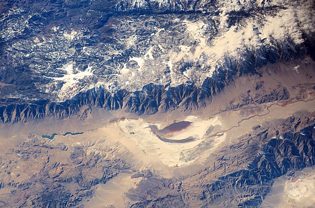
English: Astronauts aboard the International Space Station looked obliquely down at the steep eastern flank of California’s Sierra Nevada. Even from space the topography is impressive—the range drops nearly 11,000 feet from Mt. Whitney (under cloud), the highest mountain in the lower 48 states (14,494 ft), to the floor of Owens Valley (the elevation of the town of Lone Pine is 3,760 ft). The Sierra Nevada landscape is well known for deep, glacially scoured valleys, like Kern Canyon west of Mt. Whitney.
|
| Data | |
| Fonte | http://eol.jsc.nasa.gov/SearchPhotos/photo.pl?mission=ISS006&roll=E&frame=24783 |
| Autore | NASA Earth Observatory |
| Altre versioni |
|


| Posizione del soggetto | | Posizione di questa e altre immagini su: OpenStreetMap |
|---|
- Spacecraft altitude: 205 nautical miles (380km)
- I corrected contrast and color cast. —Gorthian (discussione)
Licenza
| Questo file è nel pubblico dominio perché creato dalla NASA. La politica sul copyright della NASA afferma che «il materiale della NASA non è protetto da copyright a meno che non sia specificato altrimenti». (NASA copyright policy e JPL Image Use Policy). | ||
 |
Attenzione:
|
Cronologia del file
Fare clic su un gruppo data/ora per vedere il file come si presentava nel momento indicato.
| Data/Ora | Miniatura | Dimensioni | Utente | Commento | |
|---|---|---|---|---|---|
| attuale | 09:04, 17 gen 2016 | | 3 029 × 2 002 (1,66 MB) | Gorthian | User created page with UploadWizard |
Pagine che usano questo file
La seguente pagina usa questo file:
Utilizzo globale del file
Anche i seguenti wiki usano questo file:
- Usato nelle seguenti pagine di ar.wikipedia.org:
- Usato nelle seguenti pagine di bn.wikipedia.org:
- Usato nelle seguenti pagine di en.wikipedia.org:
- Usato nelle seguenti pagine di es.wikipedia.org:
- Usato nelle seguenti pagine di fr.wikipedia.org:
- Usato nelle seguenti pagine di zh.wikipedia.org: