File:Europe 814.png

Dimensioni di questa anteprima: 777 × 600 pixel. Altre risoluzioni: 311 × 240 pixel | 622 × 480 pixel | 995 × 768 pixel | 1 280 × 988 pixel | 1 393 × 1 075 pixel.
File originale (1 393 × 1 075 pixel, dimensione del file: 169 KB, tipo MIME: image/png)
| Questo file e la sua pagina di descrizione (discussione · modifica) si trovano su Wikimedia Commons (?) |

Dettagli
| Descrizione |
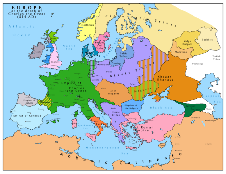
English: Map of Europe after the death of Charles the Great (814 AD). Original map made by Charles Colbeck, The Public Schools Historical Atlas (1905). |
|||
| Data | 2009-04-15. Source date: 1905 by Longmans, Green; New York, London, Bombay 1905. | |||
| Fonte | Opera propria basata su: Europe 814.jpg | |||
| Autore | Bukkia (discussione · contributi) | |||
| Altre versioni |
|


Licenza
| Io, detentore del copyright su quest'opera, la rilascio nel pubblico dominio. Questa norma si applica in tutto il mondo. In alcuni paesi questo potrebbe non essere legalmente possibile. In tal caso: Garantisco a chiunque il diritto di utilizzare quest'opera per qualsiasi scopo, senza alcuna condizione, a meno che tali condizioni siano richieste dalla legge. |
_en.png)
.png)
.jpg)
Cronologia del file
Fare clic su un gruppo data/ora per vedere il file come si presentava nel momento indicato.
| Data/Ora | Miniatura | Dimensioni | Utente | Commento | |
|---|---|---|---|---|---|
| attuale | 13:09, 26 apr 2023 | | 1 393 × 1 075 (169 KB) | OrionNimrod | Reverted to version as of 13:52, 23 December 2015 (UTC) restore |
| 18:09, 2 mag 2019 |  | 1 370 × 1 047 (124 KB) | Julieta39 | Slavs also in the Avars and Bulgars kingdoms | |
| 15:52, 23 dic 2015 |  | 1 393 × 1 075 (169 KB) | Ercwlff | at that time armenia was already part of Arab caliphate.. and there were several Georgian kingdoms or principalities in the north of them | |
| 15:52, 8 giu 2015 |  | 1 393 × 1 075 (157 KB) | Zorion | Vasconia in rebellion | |
| 19:49, 28 mag 2015 |  | 1 393 × 1 075 (156 KB) | Zorion | From 812 to 824, Vasconia was ruled by Vascons (sourced can be found anywhere in spanish, basque or french). This map was wrong for that specific year. Seems that historian wanted to credit a famous king but, he was dead when Wasconia got back under th... | |
| 17:58, 24 ago 2014 |  | 1 393 × 1 075 (230 KB) | Martin H. | Reverted to version as of 14:53, 31 January 2010: File is consistent with its source file File:Europe 814.jpg; change conflicts with en:Duchy_of_Vasconia#Carolingian duchy (769–864) | |
| 16:42, 24 ago 2014 |  | 1 393 × 1 075 (156 KB) | Zorion | Vasconia was independant from frankish kingdom until 824 | |
| 16:53, 31 gen 2010 |  | 1 393 × 1 075 (230 KB) | Bukkia | == {{int:filedesc}} == {{Information |Description={{it|1=Mappa dell'Europa alla morte di Carlo Magno (814 d.C.)}} {{en|1=Map of Europe after the death of Charles the Great (814 AD, in Italian)}} |Source=Based on File:Europe 814.jpg |Author=[[user:Buk |
Pagine che usano questo file
La seguente pagina usa questo file:
Utilizzo globale del file
Anche i seguenti wiki usano questo file:
- Usato nelle seguenti pagine di arz.wikipedia.org:
- Usato nelle seguenti pagine di bo.wikipedia.org:
- Usato nelle seguenti pagine di da.wikipedia.org:
- Usato nelle seguenti pagine di de.wikipedia.org:
- Usato nelle seguenti pagine di el.wikipedia.org:
- Usato nelle seguenti pagine di en.wikipedia.org:
- Usato nelle seguenti pagine di es.wikipedia.org:
- Usato nelle seguenti pagine di fa.wikipedia.org:
- Usato nelle seguenti pagine di fr.wikipedia.org:
- Usato nelle seguenti pagine di gl.wikipedia.org:
- Usato nelle seguenti pagine di he.wikipedia.org:
- Usato nelle seguenti pagine di hu.wikipedia.org:
- Usato nelle seguenti pagine di hy.wikipedia.org:
- Usato nelle seguenti pagine di id.wikipedia.org:
- Usato nelle seguenti pagine di ko.wikipedia.org:
- Usato nelle seguenti pagine di lmo.wikipedia.org:
- Usato nelle seguenti pagine di lv.wikipedia.org:
- Usato nelle seguenti pagine di mk.wikipedia.org:
- Usato nelle seguenti pagine di pl.wikipedia.org:
- Usato nelle seguenti pagine di ro.wikipedia.org:
- Usato nelle seguenti pagine di sh.wikipedia.org:
- Usato nelle seguenti pagine di sr.wikipedia.org:
- Usato nelle seguenti pagine di sw.wikipedia.org:
- Usato nelle seguenti pagine di uk.wikipedia.org: