File:FRONT ELEVATION FROM DISTANCE - Academy Theater, 3141 West Manchester Boulevard, Inglewood, Los Angeles County, CA HABS CAL,19-INGWO,2-2.tif

Dimensioni di questa anteprima JPG per questo file TIF: 478 × 599 pixel. Altre risoluzioni: 191 × 240 pixel | 383 × 480 pixel | 613 × 768 pixel | 817 × 1 024 pixel | 1 634 × 2 048 pixel | 3 983 × 4 993 pixel.
File originale (3 983 × 4 993 pixel, dimensione del file: 18,97 MB, tipo MIME: image/tiff)
| Questo file e la sua pagina di descrizione (discussione · modifica) si trovano su Wikimedia Commons (?) |
Dettagli
| FRONT ELEVATION FROM DISTANCE - Academy Theater, 3141 West Manchester Boulevard, Inglewood, Los Angeles County, CA | ||||
|---|---|---|---|---|
| Fotografo |
Related names:
|
|||
| Titolo |
FRONT ELEVATION FROM DISTANCE - Academy Theater, 3141 West Manchester Boulevard, Inglewood, Los Angeles County, CA |
|||
| Luogo rappresentato | California; Los Angeles County; Inglewood | |||
| Data | Documentation compiled after 1933 | |||
| Dimensioni | 4 x 5 in. | |||
| Ubicazione attuale |
Library of Congress Prints and Photographs Division Washington, D.C. 20540 USA http://hdl.loc.gov/loc.pnp/pp.print |
|||
| Numero d'inventario |
HABS CAL,19-INGWO,2-2 |
|||
| Attribuzione |
|
|||
| Note |
|
|||
| Fonte | https://www.loc.gov/pictures/item/ca0204.photos.011720p | |||
| Licenza (Riusare questo file) |
|
|||

| Posizione del soggetto | | Posizione di questa e altre immagini su: OpenStreetMap |
|---|
Cronologia del file
Fare clic su un gruppo data/ora per vedere il file come si presentava nel momento indicato.
| Data/Ora | Miniatura | Dimensioni | Utente | Commento | |
|---|---|---|---|---|---|
| attuale | 07:55, 2 lug 2014 | 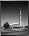 | 3 983 × 4 993 (18,97 MB) | Fæ | GWToolset: Creating mediafile for Fæ. HABS 1 July 2014 (201:300) |
Pagine che usano questo file
La seguente pagina usa questo file: