File:Karte Venedigergruppe.png
Dimensioni di questa anteprima: 774 × 600 pixel. Altre risoluzioni: 310 × 240 pixel | 619 × 480 pixel | 991 × 768 pixel | 1 280 × 992 pixel | 2 560 × 1 984 pixel | 5 130 × 3 976 pixel.
File originale (5 130 × 3 976 pixel, dimensione del file: 3,49 MB, tipo MIME: image/png)
| Questo file e la sua pagina di descrizione (discussione · modifica) si trovano su Wikimedia Commons (?) |
Dettagli
| Descrizione |
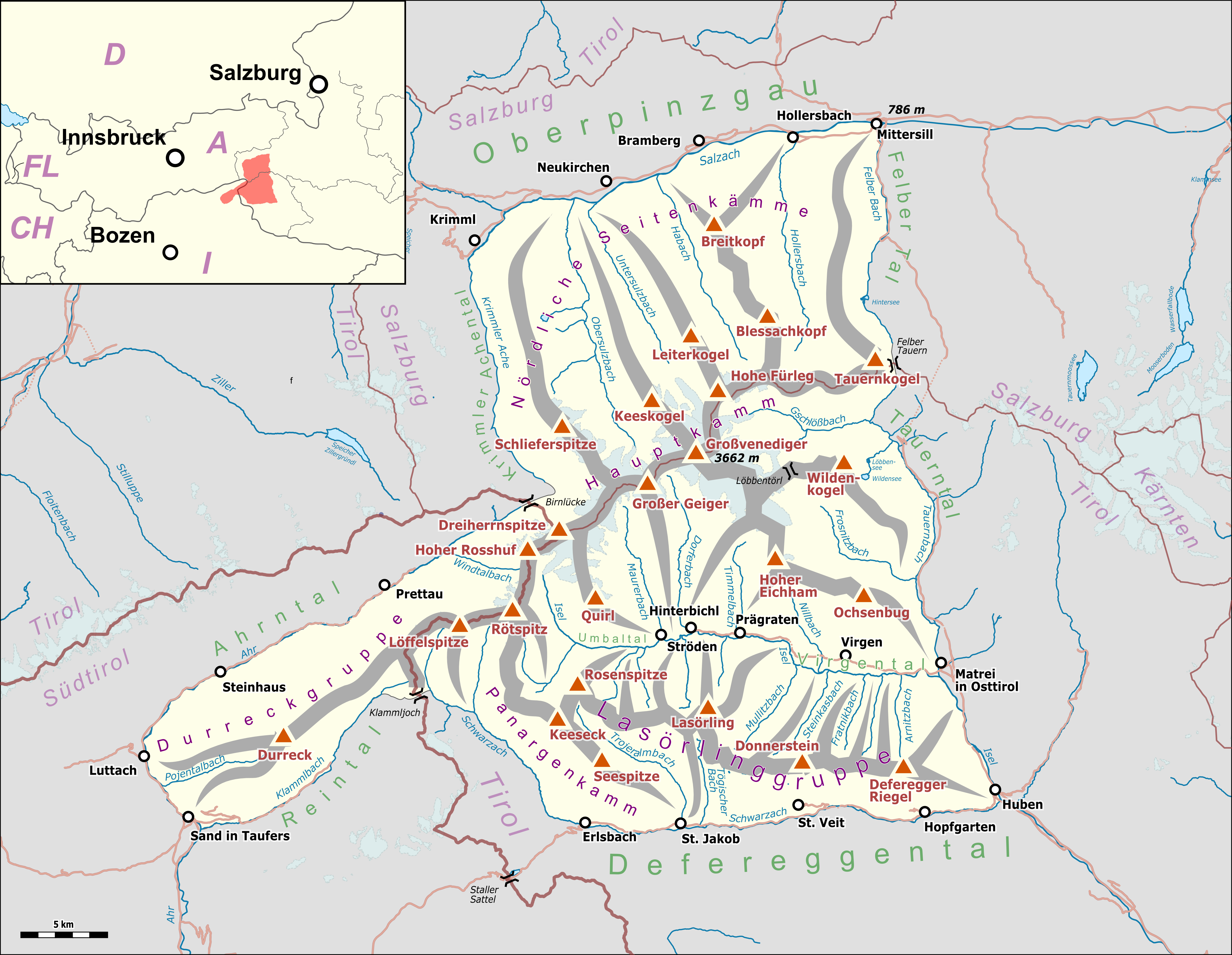
Deutsch: Übersichtskarte der Venedigergruppe. |
|||||||||
| Data | ||||||||||
| Fonte |
Map was created using:
|
|||||||||
| Creatore |
|
|||||||||
| Licenza (Riusare questo file) |
Map data (c) OpenStreetMap (and) contributors, CC-BY-SA | |||||||||
| Geotemporal data | ||||||||||
| Bounding box |
|
|||||||||
| Georeferencing | ||||||||||
| This work is licensed under the Open Database License (summary). |
Cronologia del file
Fare clic su un gruppo data/ora per vedere il file come si presentava nel momento indicato.
| Data/Ora | Miniatura | Dimensioni | Utente | Commento | |
|---|---|---|---|---|---|
| attuale | 12:50, 14 lug 2018 | | 5 130 × 3 976 (3,49 MB) | Pechristener | nachgebessert |
| 21:42, 13 lug 2018 |  | 5 130 × 3 976 (3,49 MB) | Pechristener | location map added | |
| 20:36, 13 lug 2018 |  | 5 130 × 3 976 (3,37 MB) | Pechristener | == {{int:filedesc}} == {{Map |Description={{de|1=Übersichtskarte der {{w|Venedigergruppe||de}}. }} |Source = Map was created using: *[http://www.openstreetmap.org/ Open Street Map] Data *{{w|Austria location map.svg}} for location map |Author = *Hauptkarte: Pechristener *{{w|Austria location map.svg}} : NordNordWest, {{u|Lencer}} |Date =2017-07-13 |Permission =Map data (c) OpenStreetMap (and) contributors, CC-BY-SA... |
Pagine che usano questo file
La seguente pagina usa questo file:
Utilizzo globale del file
Anche i seguenti wiki usano questo file:
- Usato nelle seguenti pagine di arz.wikipedia.org:
- Usato nelle seguenti pagine di bg.wikipedia.org:
- Usato nelle seguenti pagine di de.wikipedia.org:
- Habachtal
- Neue Prager Hütte
- Sajathütte
- Essener-Rostocker Hütte
- Kreuzspitze (Venedigergruppe)
- Schernerskopf
- Venedigergruppe
- Alte Prager Hütte
- Bonn-Matreier Hütte
- Nilljochhütte
- Lasörlinggruppe
- Liste der Gebirgsgruppen in den Ostalpen (nach AVE)
- St. Pöltner Hütte
- Eisseehütte
- Panargenkamm
- Lenkjöchlhütte
- Zupalseehütte
- Wunspitze
- Kuhhaut (Venedigergruppe)
- Türml
- Arventalspitze
- Vorlage:Positionskarte Venedigergruppe
- Benutzer Diskussion:Pechristener/Alpenkarten
- Mutti (Gratturm)
- Diskussion:Mutti (Gratturm)
- Gottschaunalm
- Liste der Dreitausender in Salzburg
- Seespitzhütte
- Benutzer:Geiserich77/Wikidata Lienz
- Usato nelle seguenti pagine di hy.wikipedia.org:
- Usato nelle seguenti pagine di www.wikidata.org: