File:Old map of Vietnam.jpg

File originale (3 024 × 2 179 pixel, dimensione del file: 1,99 MB, tipo MIME: image/jpeg)
| Questo file e la sua pagina di descrizione (discussione · modifica) si trovano su Wikimedia Commons (?) |
Dettagli
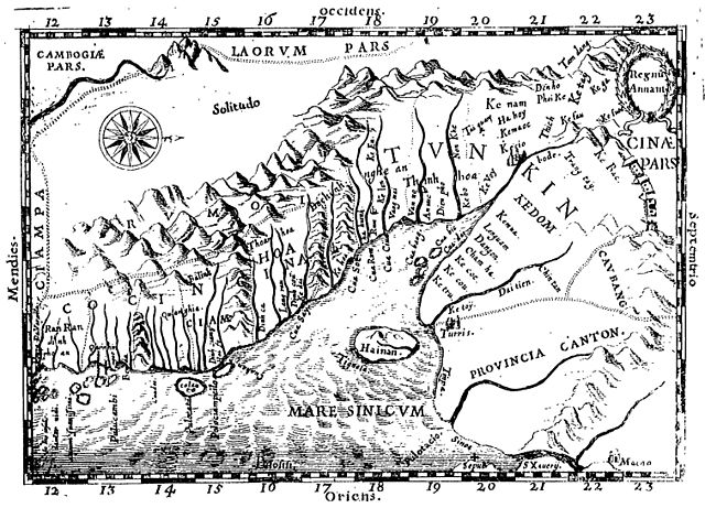
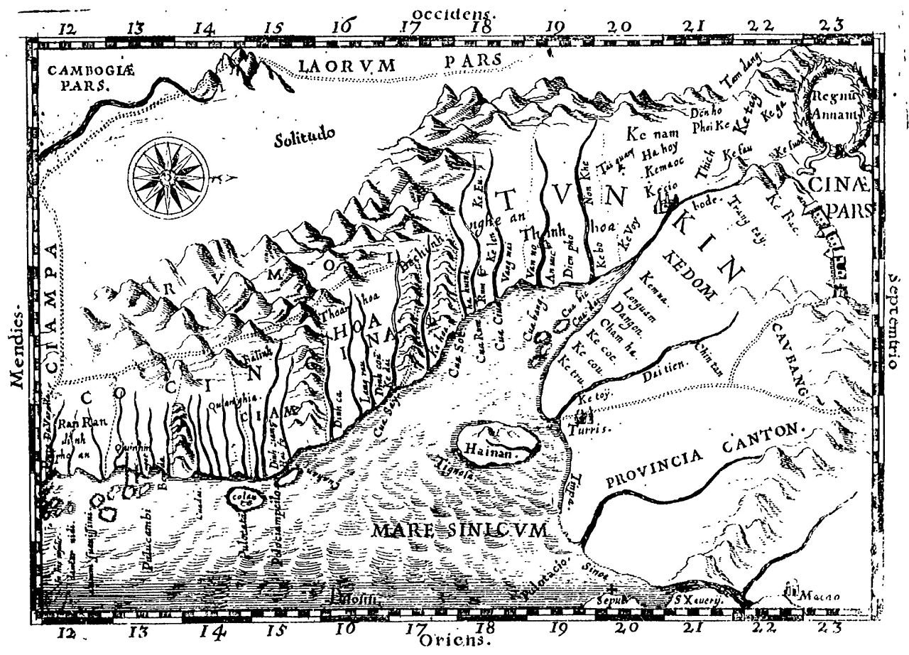
Early Western Map of Tonkin (1651). One of the earliest Western maps showing details of northern and central Vietnam appeared in Father Alexander de Rhodes's Histoire dv royavme de Tvnqvin, published in Rome in 1650. This map is from the French edition, published a year later in Lyon. Oriented with the north to the right, "Regnu Annam" shows the extent of seventeenth-century Vietnam, then divided between two rival dynasties, one in the north and the other in central Vietnam. Remnants of the Cham kingdom, eventually destroyed by the Vietnamese, still exist in the south. To the west, are the highlands occupied by "Rumoi" (upland minority groups, later called "montagnards" by the French). The limited Western knowledge of the interior is illustrated by the large region labeled "Solitudo."
(originally from https://www.loc.gov/rr/asian/guide/guide-southern.html) High-resolution version from The BNF
Licenza
|
Quest'opera è nel pubblico dominio anche in tutti i Paesi e nelle aree in cui la durata del copyright è la vita dell'autore più 70 anni o meno.
| |
| Questo file è stato identificato come libero da restrizioni conosciute riguardanti le leggi sul copyright, compresi tutti i diritti connessi e vicini. | |
Cronologia del file
Fare clic su un gruppo data/ora per vedere il file come si presentava nel momento indicato.
| Data/Ora | Miniatura | Dimensioni | Utente | Commento | |
|---|---|---|---|---|---|
| attuale | 22:28, 20 apr 2011 | | 3 024 × 2 179 (1,99 MB) | Dragfyre | cropped to center the map image |
| 13:52, 22 mag 2009 |  | 3 298 × 2 581 (1,4 MB) | DHN | updating high-res version | |
| 14:39, 9 set 2006 |  | 640 × 473 (105 KB) | DHN | Early Western Map of Tonkin (1651). One of the earliest Western maps showing details of northern and central Vietnam appeared in Father Alexander de Rhodes's Histoire dv royavme de Tvnqvin, published in Rome in 1650. This map is from the French edition, |
Pagine che usano questo file
Le seguenti 2 pagine usano questo file:
Utilizzo globale del file
Anche i seguenti wiki usano questo file:
- Usato nelle seguenti pagine di ast.wikipedia.org:
- Usato nelle seguenti pagine di azb.wikipedia.org:
- Usato nelle seguenti pagine di az.wikipedia.org:
- Usato nelle seguenti pagine di bn.wikipedia.org:
- Usato nelle seguenti pagine di br.wikipedia.org:
- Usato nelle seguenti pagine di ca.wikipedia.org:
- Usato nelle seguenti pagine di ceb.wikipedia.org:
- Usato nelle seguenti pagine di da.wikipedia.org:
- Usato nelle seguenti pagine di de.wikipedia.org:
- Usato nelle seguenti pagine di en.wikipedia.org:
- Usato nelle seguenti pagine di en.wiktionary.org:
- Usato nelle seguenti pagine di eo.wikipedia.org:
- Usato nelle seguenti pagine di es.wikipedia.org:
- Usato nelle seguenti pagine di fr.wikipedia.org:
- Usato nelle seguenti pagine di gl.wikipedia.org:
- Usato nelle seguenti pagine di id.wikipedia.org:
- Usato nelle seguenti pagine di ja.wikipedia.org:
- Usato nelle seguenti pagine di km.wikipedia.org:
- Usato nelle seguenti pagine di ms.wikipedia.org:
- Usato nelle seguenti pagine di no.wikipedia.org:
- Usato nelle seguenti pagine di pl.wikipedia.org:
- Usato nelle seguenti pagine di pt.wikipedia.org:
- Usato nelle seguenti pagine di sl.wikipedia.org:
- Usato nelle seguenti pagine di sv.wikipedia.org:
- Usato nelle seguenti pagine di vi.wikipedia.org: