File:Pacific Northwest River System.png

Dimensioni di questa anteprima: 569 × 599 pixel. Altre risoluzioni: 228 × 240 pixel | 456 × 480 pixel | 729 × 768 pixel | 973 × 1 024 pixel | 1 930 × 2 032 pixel.
File originale (1 930 × 2 032 pixel, dimensione del file: 412 KB, tipo MIME: image/png)
| Questo file e la sua pagina di descrizione (discussione · modifica) si trovano su Wikimedia Commons (?) |
Dettagli
| Descrizione |
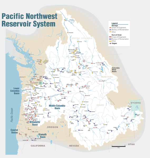
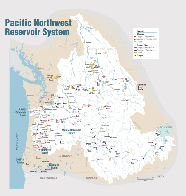
English: Maps of dams, drainage and estuaries along the Columbia River in North America (USA, Canada). Original caption: The Columbia River carved the Interior Columbia River Basin from the landscape of seven Western states and two Canadian provinces. The river itself flows from its headwaters in British Columbia, Canada through only two states, forming part of the Washington-Oregon border, the vast Interior Columbia River Basin is defined by the area drained by the river and its many tributaries. This 58-million-hectare area (about the size of France) extends roughly from the crest of the Cascade Mountains of Oregon and Washington east through Idaho to the Continental Divide in the Rocky Mountains of Montana and Wyoming, and from the headwaters of the Columbia River in Canada to the high desert of northern Nevada and northwestern Utah. |
| Data | |
| Fonte | Portland District Visual Information, U.S. Army Corps of Engineers |
| Autore | U.S. Army Corps of Engineers |
| Altre versioni |
Opere derivate da questo file: Columbia.png |
Licenza
Quest'opera è stata prodotta da un dipendente dello United States Army Corps of Engineers durante l'esercizio delle sue funzioni. Essendo un'opera del governo federale degli Stati Uniti d'America, essa è nel pubblico dominio.
|
Cronologia del file
Fare clic su un gruppo data/ora per vedere il file come si presentava nel momento indicato.
| Data/Ora | Miniatura | Dimensioni | Utente | Commento | |
|---|---|---|---|---|---|
| attuale | 00:31, 12 gen 2010 | | 1 930 × 2 032 (412 KB) | Spankston | larger file, higher resolution |
| 23:56, 11 gen 2010 |  | 914 × 963 (565 KB) | Spankston | {{Information |Description={{en|1=Maps of dams, drainage and estuaries along the Columbia River in North America (USA, Canada). Original caption: The Columbia River carved the Interior Columbia River Basin from the landscape of seven Western states a |
Pagine che usano questo file
Le seguenti 2 pagine usano questo file:
Utilizzo globale del file
Anche i seguenti wiki usano questo file:
- Usato nelle seguenti pagine di bg.wikipedia.org:
- Usato nelle seguenti pagine di de.wikipedia.org:
- Usato nelle seguenti pagine di en.wikipedia.org:
- Rocky Reach Dam
- Rock Island Dam
- Wanapum Dam
- Priest Rapids Dam
- Bonneville Dam
- Salmon River (Idaho)
- List of rivers of Washington (state)
- List of dams in the Columbia River watershed
- Revelstoke Dam
- The Dalles Dam
- Keenleyside Dam
- Columbia River Treaty
- Little Goose Dam
- Lower Granite Dam
- Lower Monumental Dam
- Ice Harbor Dam
- Dworshak Dam
- Palisades Dam
- Hells Canyon Dam
- Oxbow Dam
- Brownlee Dam
- Jackson Lake Dam
- C. J. Strike Dam
- Lake Cascade
- Deadwood Reservoir
- Lucky Peak Dam
- Arrowrock Dam
- Anderson Ranch Dam
- Zosel Dam
- User:Mdmunabbir/sandbox
- Usato nelle seguenti pagine di fi.wikipedia.org:
- Usato nelle seguenti pagine di fr.wikipedia.org:
- Usato nelle seguenti pagine di fy.wikipedia.org:
- Usato nelle seguenti pagine di he.wikipedia.org:
- Usato nelle seguenti pagine di nl.wikipedia.org:
- Usato nelle seguenti pagine di no.wikipedia.org:
Visualizza l'utilizzo globale di questo file.