File:Südtor von St.Vito 10.2.18. (BildID 15614558).jpg

Dimensioni di questa anteprima: 442 × 599 pixel. Altre risoluzioni: 177 × 240 pixel | 354 × 480 pixel | 567 × 768 pixel | 1 240 × 1 680 pixel.
File originale (1 240 × 1 680 pixel, dimensione del file: 1,06 MB, tipo MIME: image/jpeg)
| Questo file e la sua pagina di descrizione (discussione · modifica) si trovano su Wikimedia Commons (?) |
.jpg?uselang=it)
.jpg)
.jpg&action=edit)
Dettagli
| Fotografo |
Deutsch: K.u.k. Kriegspressequartier, Lichtbildstelle - Wien |
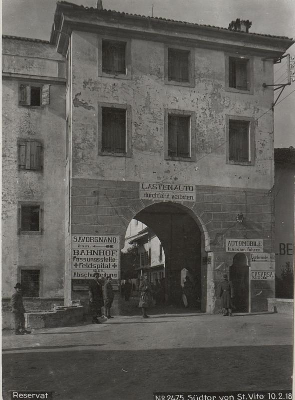
| Titolo |
Deutsch: "Torre Scaramuccia", osttor von San Vito al Tagliamento (10.2.1918).
Italiano: San Vito al Tagliamento - Torre Scaramuccia (ingresso est al centro storico) - foto del 10/2/1918.
English: San Vito al Tagliamento (Italy) - "Torre Scaramuccia" gate - photo of 10 february 1918. |
| Descrizione |
Deutsch: "Torre Scaramuccia", osttor von San Vito al Tagliamento (10.2.1918).
Italiano: San Vito al Tagliamento - Torre Scaramuccia (ingresso est al centro storico) - foto del 10/2/1918.
English: San Vito al Tagliamento (Italy) - "Torre Scaramuccia" gate (eastern entry to the historical center) - photo of 10 february 1918.
Notes about error in file name and original German caption
|
| Luogo rappresentato | Italia |
| Data | 10 febbraio 1918 |
| Numero d'inventario |
WK1/ALB077/22547 |
| Attribuzione | Österreichische Nationalbibliothek - Austrian National Library |
| Note |
Ελληνικά: Α΄ Παγκόσμιος Πόλεμος English: World War I 中文:第一次世界大战 Català: Primera Guerra Mundial Italiano: Prima guerra mondiale Čeština: První světová válka Cymraeg: Y Rhyfel Byd Cyntaf Հայերեն: Առաջին համաշխարհային պատերազմ Gaeilge: An Chéad Chogadh Domhanda Euskara: Lehen Mundu Gerra Eesti: Esimene maailmasõda Galego: Primeira Guerra Mundial Español: Primera Guerra Mundial Русский: Первая мировая война Azərbaycanca: Birinci dünya müharibəsi Português: Primeira Guerra Mundial Norsk bokmål: Første verdenskrig Türkçe: I. Dünya Savaşı Latviešu: Pirmais pasaules karš Lietuvių: Pirmasis pasaulinis karas Română: Primul Război Mondial العربية: الحرب العالمية الأولى Íslenska: Fyrri heimsstyrjöldin Polski: I wojna światowa ייִדיש: ערשטע וועלט מלחמה Беларуская: Першая сусветная вайна Français : Première Guerre mondiale Български: Първа световна война Hrvatski: Prvi svjetski rat Deutsch: Erster Weltkrieg Magyar: Első világháború हिन्दी: प्रथम विश्वयुद्ध Bosanski: Prvi svjetski rat Suomi: Ensimmäinen maailmansota Dansk: 1. verdenskrig 日本語: 第一次世界大戦 עברית: מלחמת העולם הראשונה ქართული: პირველი მსოფლიო ომი Српски / srpski: Први светски рат Shqip: Lufta e Parë Botërore 한국어: 제1차 세계 대전 Svenska: Första världskriget Македонски: Прва светска војна Slovenčina: Prvá svetová vojna Gàidhlig: An Cogadh Mòr Українська: Перша світова війна Slovenščina: Prva svetovna vojna |
| Fonte |
https://www.bildarchivaustria.at/Preview/15614558.jpg Catalog: https://www.bildarchivaustria.at/Pages/ImageDetail.aspx?p_iBildID=15614558 |
| Licenza (Riusare questo file) |
https://creativecommons.org/publicdomain/mark/1.0/ |
| Posizione del soggetto | | Posizione di questa e altre immagini su: OpenStreetMap |
|---|
.jpg¶ms=045.915116_N_0012.858122_E_globe:Earth_class:object_type:object_region:IT_&language=it)
| Luogo dello scatto | | Posizione di questa e altre immagini su: OpenStreetMap |
|---|
.jpg¶ms=045.915056_N_0012.858436_E_globe:Earth_type:camera_heading:301.44&language=it)
Licenza
|
Quest'opera è nel pubblico dominio anche in tutti i Paesi e nelle aree in cui la durata del copyright è la vita dell'autore più 80 anni o meno. Quest'opera è nel pubblico dominio negli Stati Uniti in quanto pubblicata (o registrata all'U.S. Copyright Office) prima del 1º gennaio 1929. | |
| Questo file è stato identificato come libero da restrizioni conosciute riguardanti le leggi sul copyright, compresi tutti i diritti connessi e vicini. | |
Cronologia del file
Fare clic su un gruppo data/ora per vedere il file come si presentava nel momento indicato.
| Data/Ora | Miniatura | Dimensioni | Utente | Commento | |
|---|---|---|---|---|---|
| attuale | 07:52, 16 dic 2016 | | 1 240 × 1 680 (1,06 MB) | Fæ | Austrian National Library, Kriegspressequartier Alben 1914 - 1918, ImageID 15614558, upload batch #13009 |
Pagine che usano questo file
La seguente pagina usa questo file:
.jpg)