File:1770 Janvier Map of Italy - Geographicus - Italy-janvier-1770.jpg
Dimensioni di questa anteprima: 800 × 560 pixel. Altre risoluzioni: 320 × 224 pixel | 640 × 448 pixel | 1 024 × 717 pixel | 1 280 × 896 pixel | 2 560 × 1 793 pixel | 4 000 × 2 801 pixel.
File originale (4 000 × 2 801 pixel, dimensione del file: 3,34 MB, tipo MIME: image/jpeg)
| Questo file e la sua pagina di descrizione (discussione · modifica) si trovano su Wikimedia Commons (?) |
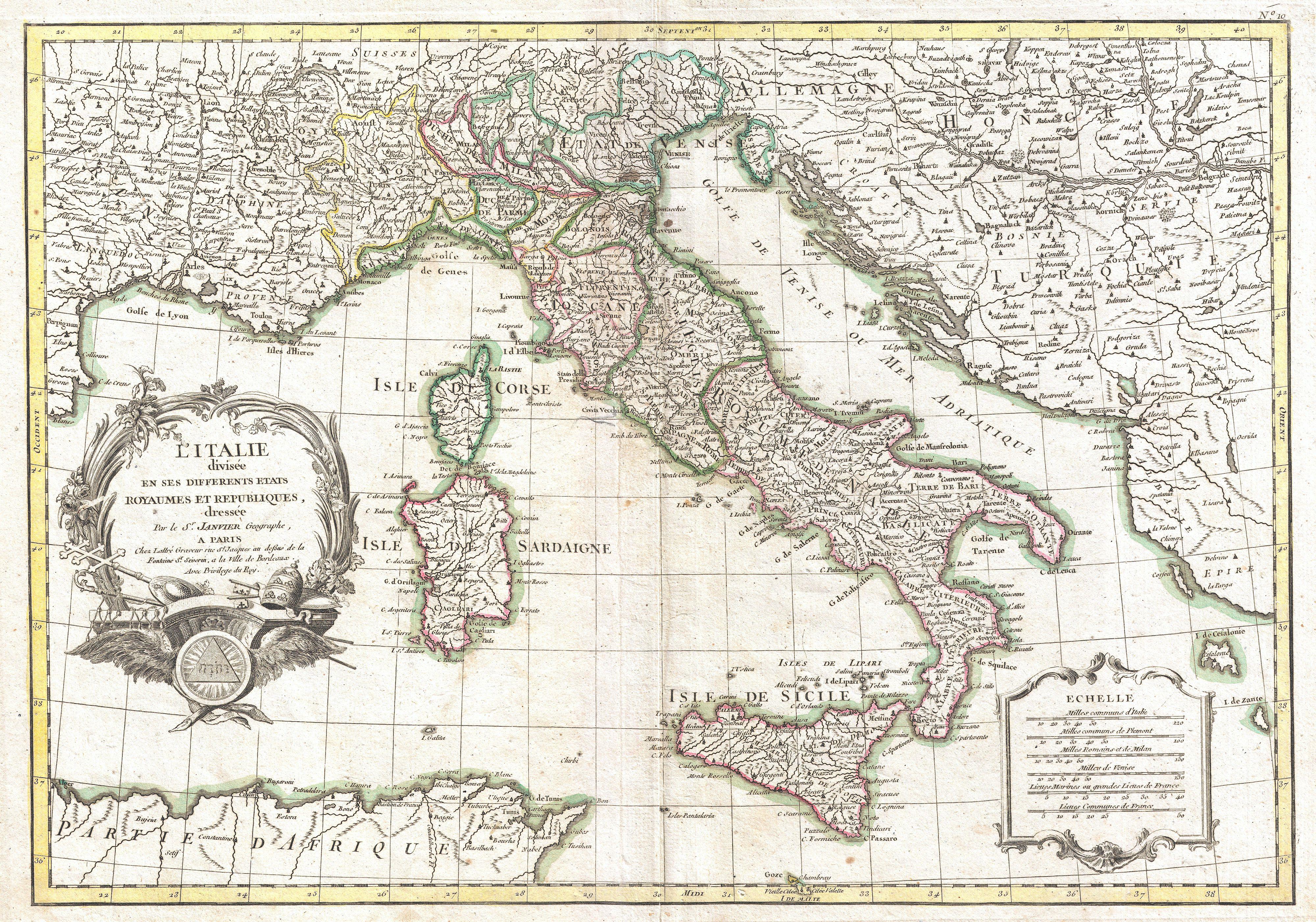
| Jean Janvier: L'Italie divisee en ses differents etats Royaumes et Republiques.
( |
|||||||||||||||||
|---|---|---|---|---|---|---|---|---|---|---|---|---|---|---|---|---|---|
| Artista |
|
||||||||||||||||
| Titolo |
L'Italie divisee en ses differents etats Royaumes et Republiques. |
||||||||||||||||
| Descrizione |
English: A beautiful example of Le Sieur Janvier's 1770 decorative map of Italy. Covers from the Gulf of Eyon eastward to include all of Corsica, Sardinia, Italy, the Adriatic, and parts of Hungary and Turkey in Europe. Extends south to include adjacent parts of Africa and north as far as Lake Geneva. An elaborate title cartouche rendered with Papal accoutrements appears in the lower left hand quadrant. A secondary cartouche bearing a six distance scales appears in the lower right. This map shows the Italian peninsula prior to its struggle for national solidarity which would emerge as a movement about 50 years later in the early 19th century. The peninsula is divided into numerous independent states, duchies, republics, kingdoms and, of course, the Papal States (States of the Church). Overall, a fine map of the region. Drawn J. Janvier c. 1770 for issue as plate nos. 10 in Jean Lattre's 1776 issue of the Atlas Moderne . |
||||||||||||||||
| Data | 1770 (undated) | ||||||||||||||||
| Dimensioni | altezza: 12,5 pollici (31,7 cm); larghezza: 17,5 pollici (44,4 cm) | ||||||||||||||||
| Numero d'inventario |
Geographicus link: Italy-janvier-1770 |
||||||||||||||||
| Fonte/Fotografo |
Lattre, Jean, Atlas Moderne ou Collection de Cartes sur Toutes les Parties du Globe Terrestre, c. 1775.
|
||||||||||||||||
| Licenza (Riusare questo file) |
|
||||||||||||||||
Cronologia del file
Fare clic su un gruppo data/ora per vedere il file come si presentava nel momento indicato.
| Data/Ora | Miniatura | Dimensioni | Utente | Commento | |
|---|---|---|---|---|---|
| attuale | 04:57, 23 mar 2011 | | 4 000 × 2 801 (3,34 MB) | BotMultichillT | {{subst:User:Multichill/Geographicus |link=http://www.geographicus.com/P/AntiqueMap/Italy-janvier-1770 |product_name=1770 Janvier Map of Italy |map_title=L'Italie divisee en ses differents etats Royaumes et Republiques. |description=A beautiful example of |
Pagine che usano questo file
Le seguenti 6 pagine usano questo file:
Utilizzo globale del file
Anche i seguenti wiki usano questo file:
- Usato nelle seguenti pagine di ast.wikipedia.org:
- Usato nelle seguenti pagine di zh.wikipedia.org:
- 古罗马
- 東羅馬帝國
- 羅馬王國
- 義大利文藝復興
- 罗马共和国
- 東哥德王國
- 意大利战争
- 伦巴第人
- 意大利殖民帝国
- 意大利統一
- 羅馬帝國
- 義大利王國 (1861年—1946年)
- 大希腊
- 西羅馬帝國
- 義大利歷史
- 義大利王國 (拿破崙時代)
- 海上共和国
- 倫巴底王國
- 羅馬歷史
- 法尔内塞家族
- 中世纪的意大利
- 罗马问题
- 貢扎加家族
- 意大利王国 (774年—962年)
- 意大利城邦
- 归尔甫派和吉伯林派
- Template:意大利历史
- 奧爾西尼家族
- 科隆納家族
- 奧比奇家族
- 德拉羅維雷
- 巴貝里尼家族
- 德拉·托雷家族
- 維斯孔蒂家族
- 博爾蓋塞家族
- 蒙特費爾特羅家族
- 馬拉泰斯塔家族
- 潘菲利家族
- User:Zzxx22ccvv/沙盒
- 埃斯特家族
- 博羅梅奧家族
- 加洛林帝国
- 意大利王国 (神圣罗马帝国)
- 托隆尼亞家族
- 南意大利的伊斯兰历史