File:3823 - Riffelberg - View from Gornergratbahn.JPG

Dimensioni di questa anteprima: 800 × 600 pixel. Altre risoluzioni: 320 × 240 pixel | 640 × 480 pixel | 1 024 × 768 pixel | 1 280 × 960 pixel | 2 560 × 1 920 pixel | 3 648 × 2 736 pixel.
File originale (3 648 × 2 736 pixel, dimensione del file: 2,69 MB, tipo MIME: image/jpeg)
| Questo file e la sua pagina di descrizione (discussione · modifica) si trovano su Wikimedia Commons (?) |
| Descrizione |
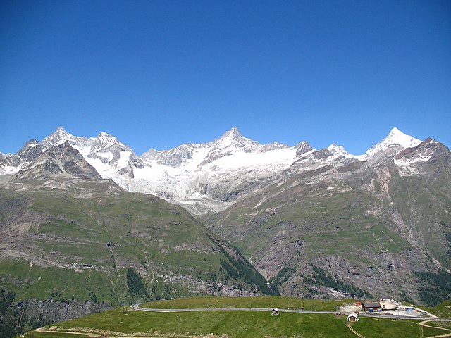
Deutsch: Ausblick von der Gornergratbahn, Riffelberg / Zermatt, Schweiz. Im Hintergrund von links nach rechts der Ober Gabelhorn (4.063 m.ü.M.), Wellenkuppe (3.903 m.ü.M.), Trifthorn (3.728 m.ü.M.), Pointe du Mountet (3.877 m.ü.M.), Zinalrothorn (4.221 m.ü.M., Bildmitte), Pointe Sud du Moming (3.963 m.ü.M.), Schahhorn (3.974,5 m.ü.M.) und Weisshorn (4.505 m). Im Vordergrund, vor den Ober Gabelhorn, liegt der Unter Gabelhorn (3.391,7 m.ü.M.). In den Grat laufend vom Zinalrothorn liegen zwei Nebengipfel, der Ober Äschhorn (3669 m.ü.M.) und der Unter Äschhorn (3.618 m.ü.M.). Weiter gibt es im Vordergrund von links nach rechts den Wisshorn (2.936 m.ü.M.), den Platthorn (3.345 m.ü.M.) und den Mettelhorn (3.406,0 m.ü.M.). Alle gehören zu den Walliser Alpen
English: View from the Gornergratbahn, Riffelberg / Zermatt, Switzerland. In the background from the left to the right the Ober Gabelhorn (4063 metres), Wellenkuppe (3903 m), Trifthorn (3728 m), Pointe du Mountet (3877 m), Zinalrothorn (4221 m, centre of the image), Pointe Sud du Moming (3963 m), Schahhorn (3974.5 m) and Weisshorn (4505 m). In the foreground, in front of the Ober Gabelhorn, lies the Unter Gabelhorn (3391.7 m). In the ridge coming from the Zinalrothorn are two side summits, the Ober Äschhorn (3669 m) and the Unter Äschhorn (3618 m). Further one can find in the foreground, from left to right, the Wisshorn (2936 m), Platthorn (3345 m) and Mettelhorn (3406.0 m). All mountains are part of the Wallis or Pennine Alps
Nederlands: Blik vanaf de Gornergratbahn, Riffelberg/Zermatt, Zwitserland. In de achtergrond van links naar rechts de Ober Gabelhorn (4063 meter), de Wellenkuppe (3903 m), de Trifthorn (3728 m), de Pointe du Mountet (3877 m), de Zinalrothorn (4221 m, midden op de foto), Pointe Sud du Moming (3963 m), Schahhorn (3974,5 m) en de Weisshorn. Op de voorgrond, voor de Ober Gabelhorn, ligt de Unter Gabelhorn (3391,7 m). In de graat lopend vanaf de top van de Zinalrothorn liggen twee neventoppen, de Ober Äschhorn (3669 m) en de Unter Äschhorn (3618 m). Verder zijn op de voorgrond, van links naar rechts, de Wisshorn (2936 m), de Platthorn (3345 m) en de Mettelhorn (3406.0 m) te zien. Alle bergen maken deel uit van de Walliser Alpen
|
||||
| Data | |||||
| Fonte | Opera propria | ||||
| Autore | Andrew Bossi | ||||
| Licenza (Riusare questo file) |
Own work, share alike, attribution required (Creative Commons CC-BY-SA-2.5) |
Io, detentore del copyright su quest'opera, dichiaro di pubblicarla con la seguente licenza:
Questo file è disponibile in base alla licenza Creative Commons Attribuzione-Condividi allo stesso modo 2.5 Generico
- Tu sei libero:
- di condividere – di copiare, distribuire e trasmettere quest'opera
- di modificare – di adattare l'opera
- Alle seguenti condizioni:
- attribuzione – Devi fornire i crediti appropriati, un collegamento alla licenza e indicare se sono state apportate modifiche. Puoi farlo in qualsiasi modo ragionevole, ma non in alcun modo che suggerisca che il licenziante approvi te o il tuo uso.
- condividi allo stesso modo – Se remixi, trasformi o sviluppi il materiale, devi distribuire i tuoi contributi in base alla stessa licenza o compatibile all'originale.
| Annotazioni | Questa immagine è annotata: Vedi le annotazioni su Commons |
Cronologia del file
Fare clic su un gruppo data/ora per vedere il file come si presentava nel momento indicato.
| Data/Ora | Miniatura | Dimensioni | Utente | Commento | |
|---|---|---|---|---|---|
| attuale | 00:28, 4 nov 2007 | | 3 648 × 2 736 (2,69 MB) | Thisisbossi | {{Information |Description={{de|Schauen vom die Gornergratbahn, Riffelberg / Zermatt, Schweiz}} {{en|View from the Gornergratbahn, [[:en:Riffelberg|Riffelberg |
Pagine che usano questo file
La seguente pagina usa questo file:
Utilizzo globale del file
Anche i seguenti wiki usano questo file:
- Usato nelle seguenti pagine di de.wikipedia.org:
- Usato nelle seguenti pagine di fr.wikipedia.org:
- Usato nelle seguenti pagine di nn.wikipedia.org:
- Usato nelle seguenti pagine di pnb.wikipedia.org: