File:Atlas Van der Hagen-KW1049B10 047-S. IMPERIUM ROMANO-GERMANICUM oder DEUTSCHLAND MIT SEINEN ANGRÄNTZENDEN KÖNIGREICHEN UND PROVINCIEN Neulich entworffen und theils gezeichnet durch IULIUM REICHELT Chur Pfaltz.jpg
Dimensioni di questa anteprima: 711 × 599 pixel. Altre risoluzioni: 285 × 240 pixel | 569 × 480 pixel | 911 × 768 pixel | 1 215 × 1 024 pixel | 2 429 × 2 048 pixel | 5 500 × 4 637 pixel.
File originale (5 500 × 4 637 pixel, dimensione del file: 5,49 MB, tipo MIME: image/jpeg)
| Questo file e la sua pagina di descrizione (discussione · modifica) si trovano su Wikimedia Commons (?) |
Dettagli
| Dirk Janszoon van Santen: Atlas van Dirk van der Hagen (volledig, collectie KB)
|
|||||||||||||||||||||||||||
|---|---|---|---|---|---|---|---|---|---|---|---|---|---|---|---|---|---|---|---|---|---|---|---|---|---|---|---|
| Artista |
Julius Reichelt Author: Julius Reichelt Publisher:
|
 | |||||||||||||||||||||||||
| Titolo |
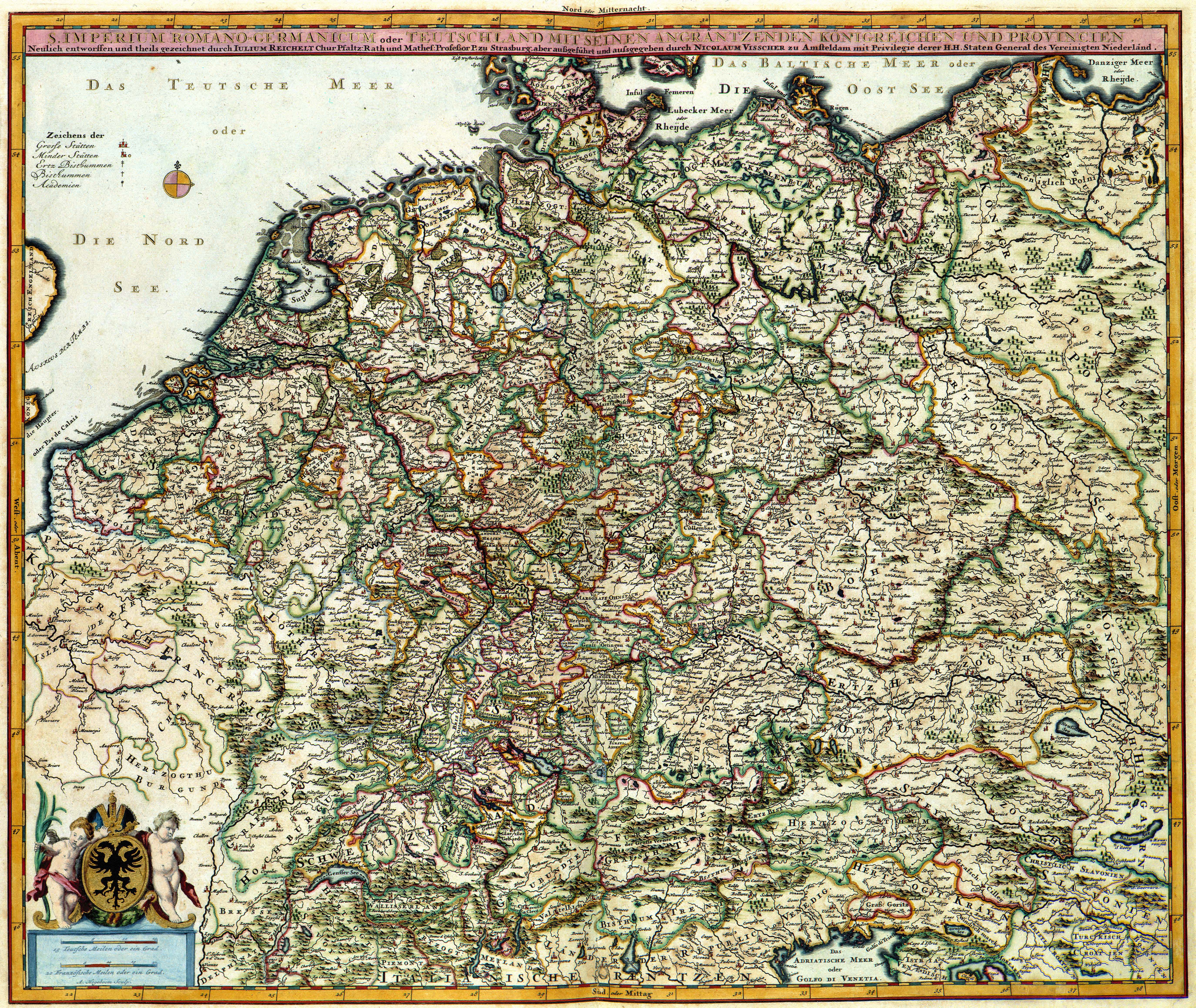
S. IMPERIUM ROMANO-GERMANICUM oder DEUTSCHLAND MIT SEINEN ANGRÄNTZENDEN KÖNIGREICHEN UND PROVINCIEN Neulich entworffen und theils gezeichnet durch IULIUM REICHELT Chur Pfaltz |
||||||||||||||||||||||||||
| Tipo di oggetto | stampa | ||||||||||||||||||||||||||
| Descrizione |
Nederlands: Deze kaart van het Duitse Rijk werd ontworpen door Julius Reichelt (1637-1717). Van Reichelt is weinig meer bekend dan dat hij hoogleraar in de wiskunde aan de Universiteit van Straatsburg was. Van zijn kaart verschenen tijdens de 17de en 18de eeuw verschillende bewerkingen. Deze bewerking is van de hand van de uitgever Nicolaes Visscher II (1649-1702).
English: This map of the German Empire was designed by Julius Reichelt (1637-1717). Reichelt was professor of mathematics at the University of Strassburg. During the 18th century many derivations appeared. This reproduction was published by Nicolaes Visscher II (1649-1702). |
||||||||||||||||||||||||||
| Lingua |
olandese |
||||||||||||||||||||||||||
| Data | dopo il 1681 | ||||||||||||||||||||||||||
| Data di pubblicazione |
circa |
||||||||||||||||||||||||||
| Tecnica/materiale |
Nederlands: kopergravure
English: incisione su rame |
||||||||||||||||||||||||||
| Dimensioni | 47 x 56 cm | ||||||||||||||||||||||||||
| Collezione |
|
||||||||||||||||||||||||||
| Numero d'inventario |
Description of the Atlas Van der Hagen in the catalogue of the KB: http://opc4.kb.nl/DB=1/TTL=1/LNG=EN/PPN?PPN=353012750 |
||||||||||||||||||||||||||
| Luogo di creazione | Amsterdam | ||||||||||||||||||||||||||
| Note | KW1049B10_047 - Volume 1 | ||||||||||||||||||||||||||
| Related persons | Nicolaes Visscher II - Reichelt, Julius | ||||||||||||||||||||||||||
| Depicted locations | German Empire | ||||||||||||||||||||||||||
| Riferimenti | |||||||||||||||||||||||||||
| Fonte/Fotografo |
Source page at the Geheugen van Nederland / Memory of the Netherlands website.
|
||||||||||||||||||||||||||

Licenza
|
Questa è una fedele riproduzione fotografica di un'opera d'arte bidimensionale originale. L'opera d'arte fotografata è nel pubblico dominio per la seguente ragione:
La posizione ufficiale presa dalla Wikimedia Foundation è che le riproduzioni fedeli di opere d'arte bidimensionali nel pubblico dominio siano da considerare anch'esse nel pubblico dominio, e che qualsiasi affermazione contraria rappresenta un attacco al concetto stesso di pubblico dominio ("faithful reproductions of two-dimensional public domain works of art are public domain, and that claims to the contrary represent an assault on the very concept of a public domain"). Per maggiori dettagli, vedi Commons:When to use the PD-Art tag.
Questa riproduzione fotografica è di conseguenza da considerarsi nel pubblico dominio. Per favore, fai attenzione al fatto che, a seconda delle leggi locali, il riutilizzo di questo contenuto potrebbe essere proibito o limitato nella tua giurisdizione. Vedi Commons:Reuse of PD-Art photographs. | ||||
Cronologia del file
Fare clic su un gruppo data/ora per vedere il file come si presentava nel momento indicato.
| Data/Ora | Miniatura | Dimensioni | Utente | Commento | |
|---|---|---|---|---|---|
| attuale | 06:21, 19 lug 2015 | | 5 500 × 4 637 (5,49 MB) | OlafJanssen | GWToolset: Creating mediafile for OlafJanssen. |
Pagine che usano questo file
La seguente pagina usa questo file:
Utilizzo globale del file
Anche i seguenti wiki usano questo file:
- Usato nelle seguenti pagine di be-tarask.wikipedia.org:
- Usato nelle seguenti pagine di bn.wikipedia.org:
- Usato nelle seguenti pagine di bs.wikipedia.org:
- Usato nelle seguenti pagine di ckb.wikipedia.org:
- Usato nelle seguenti pagine di en.wikipedia.org:
- German Empire
- East Germany
- History of Germany
- Holy Roman Empire
- Nazi Germany
- West Germany
- Weimar Republic
- Flight and expulsion of Germans (1944–1950)
- German reunification
- German diaspora
- German Confederation
- Kingdom of Prussia
- North German Confederation
- History of Germany (1945–1990)
- German Reich
- Francia
- Template:History of Germany sidebar
- Confederation of the Rhine
- List of years in Germany
- East Francia
- Allied-occupied Germany
- Military history of Germany
- Kingdom of Germany
- Kleinstaaterei
- History of German
- History of Germany during World War I
- Economic history of Germany
- History of Saxony
- Names of Germany
Visualizza l'utilizzo globale di questo file.