File:Cape Cod - Landsat 7.jpg

Dimensioni di questa anteprima: 485 × 599 pixel. Altre risoluzioni: 194 × 240 pixel | 388 × 480 pixel | 622 × 768 pixel | 829 × 1 024 pixel | 1 658 × 2 048 pixel | 3 400 × 4 200 pixel.
File originale (3 400 × 4 200 pixel, dimensione del file: 3,85 MB, tipo MIME: image/jpeg)
| Questo file e la sua pagina di descrizione (discussione · modifica) si trovano su Wikimedia Commons (?) |
Dettagli
| Descrizione |
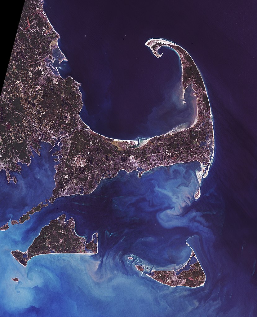
Landsat 7 image of Cape Cod, Massachusetts, 28.5 meter resolution. Based on Global Orthorectified Landsat dataset (ETM+); WRS_PATH 11, WRS_ROW 31. Generated using "true-color" combination of bands 3, 2, & 1 as R, G, B respectively. Color curves enhanced in the Gimp.
English: Cape Cod (or simply The Cape) is an arm-shaped peninsula forming the Easternmost portion of the Commonwealth of Massachusetts, USA, in the Northeastern United States. It is coextensive with Barnstable County. Although Cape Cod was originally connected to the mainland, the Cape Cod Canal, completed in 1914, effectively transformed Cape Cod into a large island.
Français : Le cap Cod (le cap aux morues), en anglais Cape Cod, est un cap ou une presqu'île sur la côte Est des États-Unis. Il se trouve dans le sud-est de l'État du Massachusetts.
Deutsch: Cape Cod (deutsch: Kap Kabeljau) ist eine 1.033 km² große Halbinsel im Südosten von Massachusetts in den USA. Im Jahre 1914 wurde ein Kanal gebaut. Die extrem langgestreckte Halbinsel wurde somit vom Festland getrennt, und die Durchfahrt vom Cape Cod Bay zum Atlantik erleichtert.
Nederlands: Cape Cod is oorspronkelijk een schiereiland aan de kust van Massachusetts. Eigenlijk is het nu een eiland omdat een kanaal het scheidt van het vasteland. Cape Cod betekent zoiets als 'kaap van de kabeljauw'. Het schiereiland kreeg deze naam al van de Europeanen in de vroege 17e eeuw toen er nog geen sprake van kolonisatie was. Er waren toen behalve bij Newfoundland ook al enorm rijke visgronden van kabeljauw bekend in de buurt van Cape Cod. Ieder jaar kwamen er grote vissersvloten uit Europa om hier te vissen. Later bleven sommige vissers het hele jaar aanwezig en vestigden zich ook op Cape Cod. Tegenwoordig is er nog steeds commerciële visserij maar die heeft het moeilijk omdat door overbevissing nog maar weinig kabeljauw is overgebleven op de eens zo rijke visgronden. Door zeebiologen wordt zelfs gevreesd dat de kabeljauw zich niet meer kan herstellen.
Norsk bokmål: Cape Cod (1033 km²) er en armformet halvøy som utgjør den østligste delen av staten Massachusetts, nordøst i Amerikas forente stater. Den er identisk med Barnstable County. Selv om Cape Cod opprinnelig hang sammen med fastlandet, ble den første Cape Cod-kanal fullført i 1914 og forandret Cape Cod i realiteten til en stor øy.
Polski: Cape Cod, przez miejscową ludność nazywany The Cape - półwysep w kształcie ramienia, położony w USA, w stanie Massachusetts w Nowej Anglii. Jego powierzchnia to 1033 km². Stanowi główną część hrabstwa Barnstable. Półwysep jest najbardziej na wschód wysuniętą częścią stanu Massachusetts. W roku 1914 ukończono budowę kanału, który oddzielił półwysep od stałego lądu. Słowo cod w języku angielskim znaczy dorsz, zaś cape - przylądek, a nazwę, nawiązującą do obfitości tych ryb w tym terenie, nadał mu podróżnik Bartholomew Gosnold w roku 1602
Slovenščina: Cape Cod je polotok v severovzhodni ameriški zvezni državi Massachusetts. Razteza se na površini 1033 km². Čeprav je bil prvotno povezan s kopnim, je leta 1914 po izgradnji kanala Cape Cod pravzaprav postal velik otok.
(This summary was created using Commons SumItUp) de:Cape Cod en:Cape Cod fr:Cap Cod nl:Cape Cod no:Cape Cod pl:Cape Cod sl:Cape Cod sv:Cape Cod zh:鳕鱼角 |
| Data | Data acquisition: 1999-09-18. Orthorectified version produced: 2002-12-29. Image created: 2007-02-06. |
| Fonte | Data from USGS GloVis server http://glovis.usgs.gov/. Landsat Orthorectified data generated through NASA's Commercial Remote Sensing Program. |
| Autore | Data: NASA. Image: Dave Pape |
| Licenza (Riusare questo file) |
Original data PD-NASA; any copyright that exists from my creation of this image is dedicated to the public domain (PD-SELF) |
| Luogo dello scatto | | Posizione di questa e altre immagini su: OpenStreetMap |
|---|
Licenza
| Questo file è nel pubblico dominio perché creato dalla NASA. La politica sul copyright della NASA afferma che «il materiale della NASA non è protetto da copyright a meno che non sia specificato altrimenti». (NASA copyright policy e JPL Image Use Policy). | ||
 |
Attenzione:
|
| Quest'opera è basata su un'opera nel pubblico dominio, ed è stata ritoccata digitalmente o modificata. Quest'opera derivata è stata (o lo è ora) rilasciata nel pubblico dominio dal suo autore, Davepape. La norma si applica in tutto il mondo. In alcuni Paesi questo potrebbe non essere legalmente possibile. In tal caso: |
Cronologia del file
Fare clic su un gruppo data/ora per vedere il file come si presentava nel momento indicato.
| Data/Ora | Miniatura | Dimensioni | Utente | Commento | |
|---|---|---|---|---|---|
| attuale | 19:44, 6 feb 2007 | | 3 400 × 4 200 (3,85 MB) | Davepape | {{de|'''Cape Cod''' (deutsch: ''Kap Kabeljau'') ist eine 1.033 km² große de:Halbinsel im Südosten von de:Massachusetts in den de:USA. Im Jahre de:1914 wurde ein Kanal gebaut. Die extrem langgestreckte H |
Pagine che usano questo file
Le seguenti 2 pagine usano questo file:
Utilizzo globale del file
Anche i seguenti wiki usano questo file:
- Usato nelle seguenti pagine di ar.wikipedia.org:
- Usato nelle seguenti pagine di az.wikipedia.org:
- Usato nelle seguenti pagine di bn.wikipedia.org:
- Usato nelle seguenti pagine di cs.wikipedia.org:
- Usato nelle seguenti pagine di da.wikipedia.org:
- Usato nelle seguenti pagine di de.wikipedia.org:
- Usato nelle seguenti pagine di en.wikipedia.org:
- Talk:Cranberry
- Talk:Guglielmo Marconi
- Talk:John F. Kennedy
- Talk:Judy Blume
- Talk:Lucretia Mott
- List of peninsulas
- Talk:Vinland
- Talk:Pilgrims (Plymouth Colony)
- Talk:Nantucket
- Talk:Hillary Clinton
- Talk:Kim Deal
- Talk:Joss Whedon
- Talk:Joshua Slocum
- Talk:John Smith (explorer)
- Talk:Lymantria dispar
- Talk:Shawn Fanning
- Talk:Walter Cronkite
- Talk:Judy Garland
- Talk:George H. W. Bush
- Talk:Barnstable County, Massachusetts
- Talk:Dukes County, Massachusetts
- Talk:Meg Ryan
- Talk:RMS Olympic
- Talk:Joseph P. Kennedy Sr.
- Talk:Henry David Thoreau
- Talk:Jacqueline Kennedy Onassis
- Talk:Giovanni da Verrazzano
- Talk:Minke whale
- Talk:Samuel de Champlain
- Talk:Moby-Dick
- Talk:Naushon Island
- Talk:Wampanoag people
- Talk:Patrick Bouvier Kennedy
- Talk:Mary Jo Kopechne
- Talk:Massachusett language
- Talk:Cape Cod
- Talk:Teresa Heinz
- Talk:Humpback whale
- Talk:Larry David
- Talk:Fox Mulder
- Talk:Jack Kerouac
- Talk:Hurricane Bob
- Talk:Mike Wallace
- Talk:Essex (whaleship)
Visualizza l'utilizzo globale di questo file.