File:Concord Retreat.png
Dimensioni di questa anteprima: 800 × 342 pixel. Altre risoluzioni: 320 × 137 pixel | 640 × 273 pixel | 1 024 × 437 pixel | 1 280 × 546 pixel | 3 235 × 1 381 pixel.
File originale (3 235 × 1 381 pixel, dimensione del file: 780 KB, tipo MIME: image/png)
| Questo file e la sua pagina di descrizione (discussione · modifica) si trovano su Wikimedia Commons (?) |
Dettagli
| Descrizione |
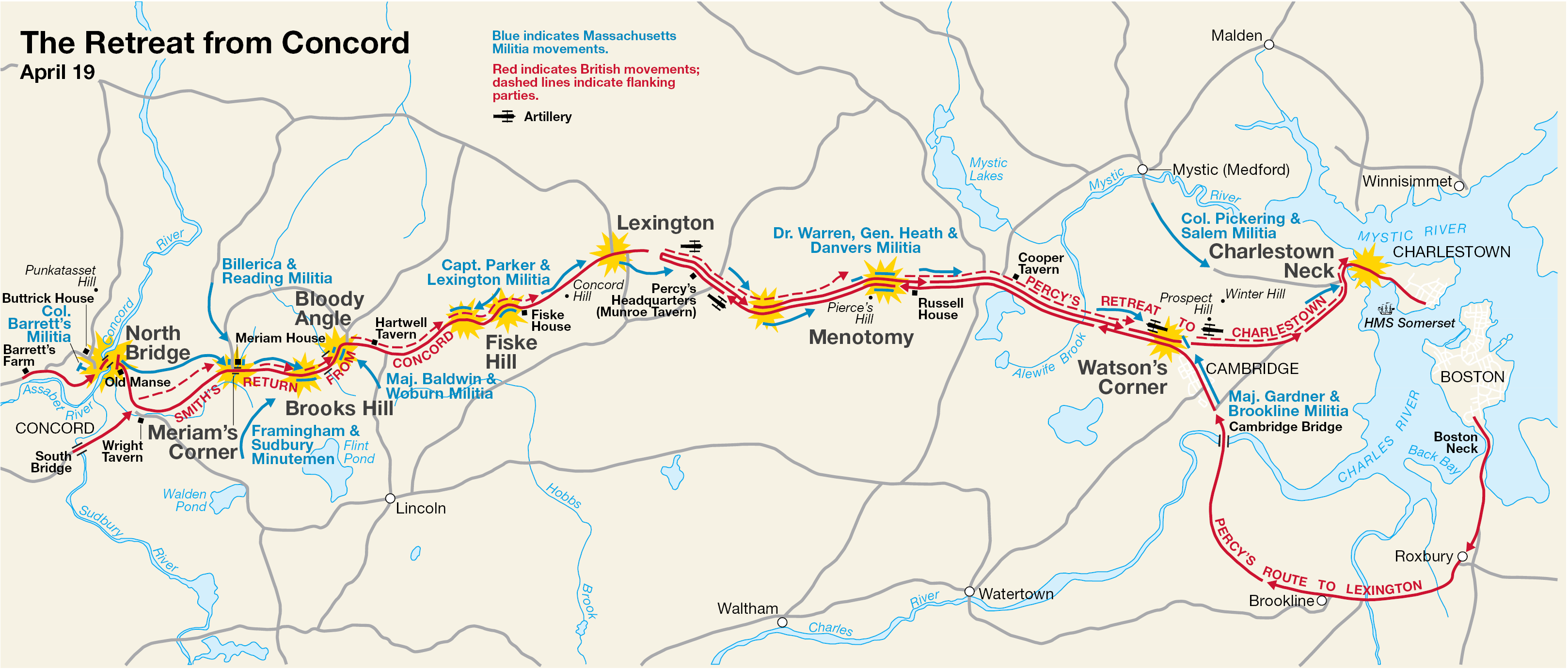
English: This is a map showing the route of the British army's 18-mile retreat from Concord to Charlestown in the Battles of Lexington and Concord on April 19, 1775. It shows the major points of conflict, as well as showing the route taken by Hugh, Earl Percy's reinforcements. |
| Data | Data sconosciuta; source PDF created in 2000 |
| Fonte | http://data2.itc.nps.gov/parks/mima/ppMaps/MIMAmap2.pdf |
| Autore | National Park Service |
| Altre versioni |
|

Licenza
| This image or media file contains material based on a work of a National Park Service employee, created as part of that person's official duties. As a work of the U.S. federal government, such work is in the public domain in the United States. See the NPS website and NPS copyright policy for more information. |
Registro originale del caricamento
Trasferito da en.wikipedia su Commons da Andrei Stroe utilizzando CommonsHelper.
La pagina di descrizione originale era qui. Tutti i nomi utente che seguono sono riferiti a en.wikipedia.
- 2006-11-30 17:35 Irayo 3235×1381× (799048 bytes) The Retreat from Concord April 19 (1775) Minute Man National Historical Park Battle Map http://data2.itc.nps.gov/parks/mima/ppMaps/MIMAmap2.pdf {{PD-USGov-Interior-NPS}}
Cronologia del file
Fare clic su un gruppo data/ora per vedere il file come si presentava nel momento indicato.
| Data/Ora | Miniatura | Dimensioni | Utente | Commento | |
|---|---|---|---|---|---|
| attuale | 21:11, 29 nov 2010 | | 3 235 × 1 381 (780 KB) | File Upload Bot (Magnus Manske) | {{BotMoveToCommons|en.wikipedia|year={{subst:CURRENTYEAR}}|month={{subst:CURRENTMONTHNAME}}|day={{subst:CURRENTDAY}}}} {{Information |Description={{en|This is a map showing the route of the British army's 18-mile retreat from [[:en:Concord, Massachusetts |
Pagine che usano questo file
La seguente pagina usa questo file:
Utilizzo globale del file
Anche i seguenti wiki usano questo file:
- Usato nelle seguenti pagine di ar.wikipedia.org:
- Usato nelle seguenti pagine di azb.wikipedia.org:
- Usato nelle seguenti pagine di cs.wikipedia.org:
- Usato nelle seguenti pagine di en.wikipedia.org:
- Usato nelle seguenti pagine di es.wikipedia.org:
- Usato nelle seguenti pagine di fr.wikipedia.org:
- Usato nelle seguenti pagine di ro.wikipedia.org:
- Usato nelle seguenti pagine di ru.wikipedia.org:
- Usato nelle seguenti pagine di th.wikipedia.org:
- Usato nelle seguenti pagine di zh.wikipedia.org: