File:Egypt under Muhammad Ali Dynasty map de 2.png

Dimensioni di questa anteprima: 532 × 600 pixel. Altre risoluzioni: 213 × 240 pixel | 426 × 480 pixel | 681 × 768 pixel | 908 × 1 024 pixel | 1 998 × 2 253 pixel.
File originale (1 998 × 2 253 pixel, dimensione del file: 1,1 MB, tipo MIME: image/png)
| Questo file e la sua pagina di descrizione (discussione · modifica) si trovano su Wikimedia Commons (?) |
Dettagli
| Descrizione |
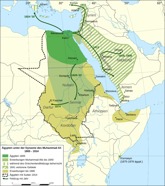
English: Map of Egypt under Muhammad Ali Dynasty in German.
Deutsch: Karte Ägyptens unter der Dynastie von Muhammad Ali, in mehreren Phasen.
Quellen:
|
| Data | |
| Fonte | Opera propria, derivate of File:Africa location map.svg |
| Autore | Don-kun, Eric Gaba (Sting - fr:Sting) |
| Altre versioni |
|


Licenza
Io, detentore del copyright su quest'opera, dichiaro di pubblicarla con le seguenti licenze:

|
È permesso copiare, distribuire e/o modificare questo documento in base ai termini della GNU Free Documentation License, Versione 1.2 o successive pubblicata dalla Free Software Foundation; senza alcuna sezione non modificabile, senza testo di copertina e senza testo di quarta di copertina. Una copia della licenza è inclusa nella sezione intitolata Testo della GNU Free Documentation License. |
Questo file è disponibile in base alla licenza Creative Commons Attribuzione 3.0 Unported
- Tu sei libero:
- di condividere – di copiare, distribuire e trasmettere quest'opera
- di modificare – di adattare l'opera
- Alle seguenti condizioni:
- attribuzione – Devi fornire i crediti appropriati, un collegamento alla licenza e indicare se sono state apportate modifiche. Puoi farlo in qualsiasi modo ragionevole, ma non in alcun modo che suggerisca che il licenziante approvi te o il tuo uso.
Puoi scegliere la licenza che preferisci.
Cronologia del file
Fare clic su un gruppo data/ora per vedere il file come si presentava nel momento indicato.
| Data/Ora | Miniatura | Dimensioni | Utente | Commento | |
|---|---|---|---|---|---|
| attuale | 19:24, 3 feb 2016 | | 1 998 × 2 253 (1,1 MB) | Don-kun | corrections |
| 22:51, 28 ott 2011 |  | 1 998 × 2 253 (1,07 MB) | Don-kun | mehr Beschriftungen | |
| 22:45, 15 ott 2011 |  | 1 998 × 2 253 (1,01 MB) | Don-kun | Korrekturen Somalia, andere Darstellung in Asien, griech. Herrschaft | |
| 23:04, 12 ott 2011 |  | 1 996 × 2 081 (912 KB) | Don-kun | some corrections | |
| 21:39, 6 ott 2011 |  | 1 996 × 2 081 (913 KB) | Don-kun | correction in Libya and Arabia | |
| 17:07, 5 ott 2011 |  | 1 996 × 2 081 (810 KB) | Don-kun | {{Information |Description ={{en|1=Map of Egypt under Muhammad Ali Dynasty.}} {{de|1=Karte Ägyptens unter der Dynastie von Muhammad Ali, in mehreren Phasen. Quellen: * Putzger Historischer Weltatlas. Cornelsen Verlag 2001. * dtv-Atlas Weltgeschichte, |
Pagine che usano questo file
La seguente pagina usa questo file:
Utilizzo globale del file
Anche i seguenti wiki usano questo file:
- Usato nelle seguenti pagine di de.wikipedia.org:
- Usato nelle seguenti pagine di ka.wikipedia.org: