File:Fires along the Rio Xingu, Brazil - NASA Earth Observatory.jpg

File originale (1 440 × 960 pixel, dimensione del file: 329 KB, tipo MIME: image/jpeg)
| Questo file e la sua pagina di descrizione (discussione · modifica) si trovano su Wikimedia Commons (?) |
Dettagli
| Descrizione |
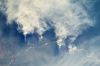
English: The rainforest of South America, also known as Amazonia, has been undergoing a continual and accelerated conversion process into farmlands (including pasture for livestock) since the early 1960s. This process has typically been achieved by clearing the forest using fire—“slash and burn”—followed by planting of crops. The generally infertile soils of this rainforest—the largest such forest on Earth—make sustainable farming difficult. This drives people to convert more forest into farmland. The area of clearing can be considerable, and since the deforested regions are easily identifiable and measurable from space, the rate of deforestation is likewise easy to track.
This astronaut photograph illustrates slash-and-burn forest clearing along the Rio Xingu (Xingu River) in the state of Matto Grasso, Brazil. The photo was taken from the International Space Station, a platform from which astronauts can capture images of the Earth from a variety of viewing angles. The perspective above shows both the horizontal position and the extent of the fire lines next to the river, while also providing a sense of the vertical structure of the smoke plumes. Light colored areas within the river channel are sand bars, which show that the river is in its annual low-flow/low-water stage. For a sense of scale, the river channel is approximately 63 kilometers (39 miles) long in this view. Rivers are the natural highways in Amazonia, which may explain why the burning is occurring right next to the Xingu River, one of Amazonia’s largest. In recent years, forest preservation has gained traction in the region as a result of new valuation of the ecosystem services provided by the forest, concerns about the impact of the burning on global climate change, and greater sensitivity to the ethnic and biological heritage of Amazonia. Astronaut photograph ISS029-E-8032 was acquired on September 17, 2011, with a Nikon D2Xs digital camera using a 200 mm lens, and is provided by the ISS Crew Earth Observations experiment and Image Science & Analysis Laboratory, Johnson Space Center. The image was taken by the Expedition 29 crew. The image has been cropped and enhanced to improve contrast. Lens artifacts have been removed. The International Space Station Program supports the laboratory as part of the ISS National Lab to help astronauts take pictures of Earth that will be of the greatest value to scientists and the public, and to make those images freely available on the Internet. Additional images taken by astronauts and cosmonauts can be viewed at the NASA/JSC Gateway to Astronaut Photography of Earth. Caption by William L. Stefanov, Jacobs/ESCG at NASA-JSC.
|
||||||||||||||||||||||||||||||||||||||||||||||||||
| Data | |||||||||||||||||||||||||||||||||||||||||||||||||||
| Fonte | Fires along the Rio Xingu, Brazil | ||||||||||||||||||||||||||||||||||||||||||||||||||
| Autore | NASA's Earth Observatory | ||||||||||||||||||||||||||||||||||||||||||||||||||
| Altre versioni |
|
||||||||||||||||||||||||||||||||||||||||||||||||||


| Luogo dello scatto | | Posizione di questa e altre immagini su: OpenStreetMap |
|---|
Licenza
- Tu sei libero:
- di condividere – di copiare, distribuire e trasmettere quest'opera
- di modificare – di adattare l'opera
- Alle seguenti condizioni:
- attribuzione – Devi fornire i crediti appropriati, un collegamento alla licenza e indicare se sono state apportate modifiche. Puoi farlo in qualsiasi modo ragionevole, ma non in alcun modo che suggerisca che il licenziante approvi te o il tuo uso.
| Questa immagine è stata originariamente caricata su Flickr da NASA Earth Observatory all'indirizzo https://www.flickr.com/photos/68824346@N02/6283416535. È stata controllata in data 2 luglio 2012 dal robot FlickreviewR ed è stato confermato il suo rilascio sotto i termini della licenza cc-by-2.0. |
"The Gateway to Astronaut Photography of Earth". Le immagini provengono dall'Image Science & Analysis Laboratory, della NASA Johnson Space Center.
Fonte della foto: ISS029-E-8032.
|
Cronologia del file
Fare clic su un gruppo data/ora per vedere il file come si presentava nel momento indicato.
| Data/Ora | Miniatura | Dimensioni | Utente | Commento | |
|---|---|---|---|---|---|
| attuale | 19:22, 2 lug 2012 | | 1 440 × 960 (329 KB) | Dzlinker | == {{int:filedesc}} == {{Information |Description=The rainforest of South America, also known as Amazonia, has been undergoing a continual and accelerated conversion process into farmlands (including pasture for livestock) since the early 1960s. This p... |
Pagine che usano questo file
La seguente pagina usa questo file:
Utilizzo globale del file
Anche i seguenti wiki usano questo file:
- Usato nelle seguenti pagine di en.wikipedia.org:
- Usato nelle seguenti pagine di id.wikipedia.org:
- Usato nelle seguenti pagine di no.wikipedia.org:
- Usato nelle seguenti pagine di vi.wikipedia.org: