File:High Asia Mountain Ranges.jpg

Dimensioni di questa anteprima: 763 × 600 pixel. Altre risoluzioni: 306 × 240 pixel | 611 × 480 pixel | 978 × 768 pixel | 1 280 × 1 006 pixel | 2 560 × 2 011 pixel | 5 600 × 4 400 pixel.
File originale (5 600 × 4 400 pixel, dimensione del file: 10,79 MB, tipo MIME: image/jpeg)
| Questo file e la sua pagina di descrizione (discussione · modifica) si trovano su Wikimedia Commons (?) |
Dettagli
| Descrizione |
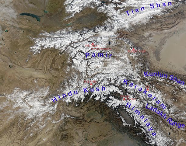
English: high Asian mountain ranges and their highest mountains:
Deutsch: Die innerasiatischen Hochgebirge:
|
| Data | (UTC) |
| Fonte |
Questo file deriva da: Hindu Kush satellite image.jpg: |
| Autore |
|
| Questa è una immagine ritoccata, il che significa che è stata modificata digitalmente dalla sua versione originale. Modifiche: mountain ranges (and highest mountains) labelled. La versione originale può essere vista qui: Hindu Kush satellite image.jpg. Le modifiche sono di Rupert Pupkin.
|
Licenza
| Questo file è nel pubblico dominio perché creato dalla NASA. La politica sul copyright della NASA afferma che «il materiale della NASA non è protetto da copyright a meno che non sia specificato altrimenti». (NASA copyright policy e JPL Image Use Policy). | ||
 |
Attenzione:
|
Registro originale del caricamento
This image is a derivative work of the following images:
- File:Hindu_Kush_satellite_image.jpg licensed with PD-USGov-NASA
- 2006-06-06T04:39:19Z Avenue 5600x4400 (5255682 Bytes) {{Information |Description=The Hindu Kush occupies the lower-left-center of this true-color MODIS satellite image, acquired 28 November 2003. |Source=[NASA's Earth Observatory http://earthobservatory.nasa.gov/Newsroom/NewImag
Uploaded with derivativeFX
Cronologia del file
Fare clic su un gruppo data/ora per vedere il file come si presentava nel momento indicato.
| Data/Ora | Miniatura | Dimensioni | Utente | Commento | |
|---|---|---|---|---|---|
| attuale | 15:05, 27 nov 2012 | | 5 600 × 4 400 (10,79 MB) | Rupert Pupkin | ladakh range added |
| 13:15, 27 nov 2012 |  | 5 600 × 4 400 (10,71 MB) | Rupert Pupkin | == {{int:filedesc}} == {{Information |Description=The Hindu Kush occupies the lower-left-center of this true-color MODIS satellite image, acquired 28 November 2003. |Source={{Derived from|Hindu_Kush_satellite_image.jpg|display=50}} |Date=2012-11-27 11:... |
Pagine che usano questo file
Le seguenti 2 pagine usano questo file:
Utilizzo globale del file
Anche i seguenti wiki usano questo file:
- Usato nelle seguenti pagine di af.wikipedia.org:
- Usato nelle seguenti pagine di ba.wikipedia.org:
- Usato nelle seguenti pagine di bcl.wikipedia.org:
- Usato nelle seguenti pagine di bn.wikipedia.org:
- Usato nelle seguenti pagine di ceb.wikipedia.org:
- Usato nelle seguenti pagine di de.wikipedia.org:
- Usato nelle seguenti pagine di en.wikipedia.org:
- Usato nelle seguenti pagine di en.wikivoyage.org:
- Usato nelle seguenti pagine di es.wikipedia.org:
- Usato nelle seguenti pagine di eu.wikipedia.org:
- Usato nelle seguenti pagine di fa.wikipedia.org:
- Usato nelle seguenti pagine di fa.wikivoyage.org:
- Usato nelle seguenti pagine di fr.wikipedia.org:
- Usato nelle seguenti pagine di hy.wikipedia.org:
- Usato nelle seguenti pagine di id.wikipedia.org:
- Usato nelle seguenti pagine di lt.wikipedia.org:
- Usato nelle seguenti pagine di ms.wikipedia.org:
- Usato nelle seguenti pagine di nl.wikipedia.org:
- Usato nelle seguenti pagine di pl.wikipedia.org:
- Usato nelle seguenti pagine di pnb.wikipedia.org:
- Usato nelle seguenti pagine di ps.wikipedia.org:
- Usato nelle seguenti pagine di pt.wikipedia.org:
- Usato nelle seguenti pagine di ru.wikipedia.org:
- Usato nelle seguenti pagine di sco.wikipedia.org:
- Usato nelle seguenti pagine di sd.wikipedia.org:
- Usato nelle seguenti pagine di simple.wikipedia.org:
- Usato nelle seguenti pagine di sl.wikipedia.org:
- Usato nelle seguenti pagine di sv.wikipedia.org:
- Usato nelle seguenti pagine di ta.wikipedia.org:
Visualizza l'utilizzo globale di questo file.