File:Horseshoe bend map.jpg
Dimensioni di questa anteprima: 671 × 600 pixel. Altre risoluzioni: 269 × 240 pixel | 537 × 480 pixel | 859 × 768 pixel | 1 244 × 1 112 pixel.
File originale (1 244 × 1 112 pixel, dimensione del file: 231 KB, tipo MIME: image/jpeg)
| Questo file e la sua pagina di descrizione (discussione · modifica) si trovano su Wikimedia Commons (?) |
Dettagli
| Descrizione |
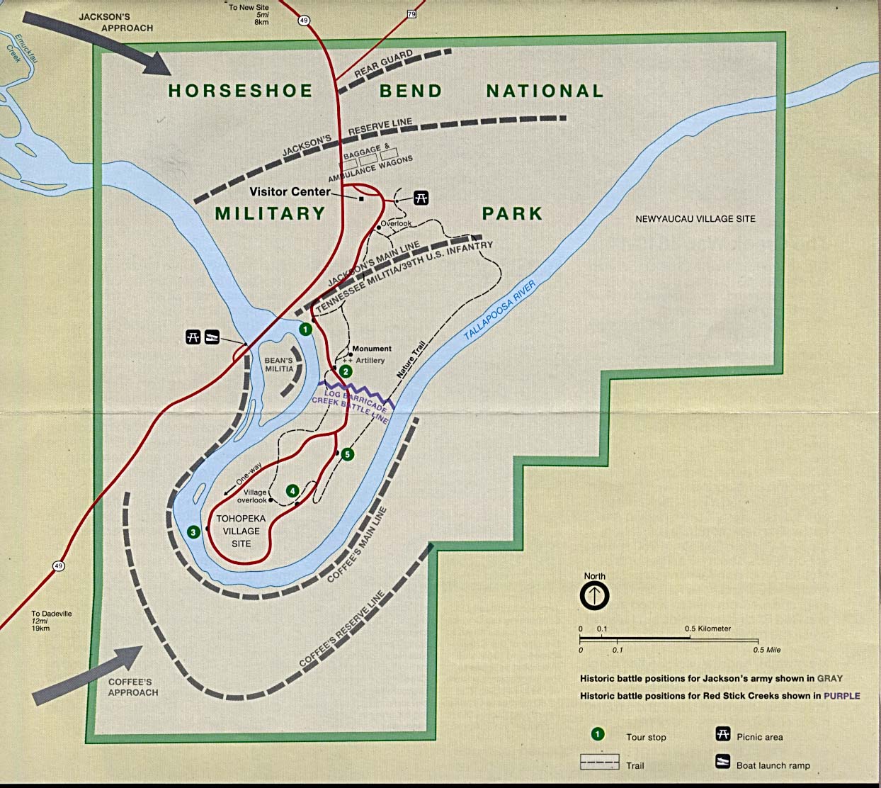
English: This image is held in the PCL Map Collection at the University of Texas Libraries, The University of Texas at Austin. (Copyrighted material in this collection is clearly marked.) The map shows the Horseshoe Bend National Military Park and is annotated with the historical battle positions of Jackson's Army and the Creek Red Sticks. |
| Data | 1 agosto 2005 (data di caricamento originaria) |
| Fonte | Trasferito da en.wikipedia su Commons. Retrieved from here |
| Autore | "Courtesy of the University of Texas Libraries, The University of Texas at Austin." |
Licenza
See online license
| Quest'opera è stata rilasciata nel pubblico dominio dal suo autore, PCL Map Collection at the University of Texas Libraries. Questa norma si applica in tutto il mondo. In alcuni paesi questo potrebbe non essere legalmente possibile. In tal caso: PCL Map Collection at the University of Texas Libraries garantisce a chiunque il diritto di utilizzare quest'opera per qualsiasi scopo, senza alcuna condizione, a meno che tali condizioni siano richieste dalla legge.
|
Registro originale del caricamento
La pagina di descrizione originale era qui. Tutti i nomi utente che seguono sono riferiti a en.wikipedia.
- 2005-08-01 20:12 Vern Reisenleiter 1244×1112× (236405 bytes) This image is held in the PCL Map Collection at the University of Texas Libraries, The University of Texas at Austin. (Copyrighted material in this collection is clearly marked.) The map shows the Horseshoe Bend National Miltary Park and is annotat
Cronologia del file
Fare clic su un gruppo data/ora per vedere il file come si presentava nel momento indicato.
| Data/Ora | Miniatura | Dimensioni | Utente | Commento | |
|---|---|---|---|---|---|
| attuale | 17:59, 23 giu 2014 | | 1 244 × 1 112 (231 KB) | Jalo | Transferred from en.wikipedia |
Pagine che usano questo file
La seguente pagina usa questo file:
Utilizzo globale del file
Anche i seguenti wiki usano questo file:
- Usato nelle seguenti pagine di ca.wikipedia.org:
- Usato nelle seguenti pagine di en.wikipedia.org:
- Usato nelle seguenti pagine di en.wikivoyage.org:
- Usato nelle seguenti pagine di ru.wikipedia.org: