File:JamesMillerHouse.jpg
Non sono disponibili versioni a risoluzione più elevata.
JamesMillerHouse.jpg (600 × 431 pixel, dimensione del file: 143 KB, tipo MIME: image/jpeg)
| Questo file e la sua pagina di descrizione (discussione · modifica) si trovano su Wikimedia Commons (?) |
|
Questa è un'immagine di un luogo o edificio che è elencato nel National Register of Historic Places negli Stati Uniti. Il suo numero di riferimento è [https://npgallery.nps.gov/AssetDetail/NRIS/75001605
. 75001605
.]. |

|
Questo file è stato trasferito su Wikimedia Commons da en.wikipedia utilizzando uno script per bot. Tutte le informazioni riguardanti la fonte del file sono ancora presenti. Tuttavia, necessitano di un controllo umano. Inoltre, potrebbero esserci degli errori nella visualizzazione di tutte le informazioni del file, dovuti alle differenze esistenti fra i template dei progetti Wikimedia. Di conseguenza, le informazioni su questo file non dovrebbero essere considerate attendibili e il file non dovrebbe essere riutilizzato finché non è stato controllato e finché tutte le correzioni necessarie non sono state fatte. Una volta eseguito il controllo, per favore rimuovi questo avviso. Per maggiori dettagli, vedi sotto. Controlla adesso! |
Dettagli
| Descrizione |
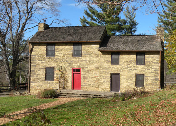
English: Picture of the James Miller House (aka "Stone Manse") at the Oliver Miller Homestead located at 1 Stone Manse Drive in South Park Township, Allegheny County, Pennsylvania, on November 14, 2009. The property on which this house sits was first settled by Oliver Miller in 1772. Oliver's youngest son James inherited the property in 1782. James was married in 1787 and had eight children. In 1794, the first fired gunshots of the Whiskey Rebellion occurred on the property. On July 15, 1794, two Federal revenue officers served a writ on William Miller (James' brother), but, after leaving the paper, they were met by an armed group of his neighbors. A shot was heard as the Federal revenue officers rode off, but neither man was injured. The family was later pardoned for any role they may have played in the rebellion. In 1808, James added a stone section to the original log house that his father had built. This addition met their needs until 1830, when James' son Oliver, and his wife, came to live with them. At this time, the log house was replaced with a large stone section making it the farmhouse as it stands today. Five generations of Millers lived at this homestead until 1927, when Allegheny County purchased the land from the last remaining Miller descendant for the formation of South Park. Today, the homestead is a public museum that commemorates pioneer settlers of Western Pennsylvania, and the house is listed on the National Register of Historic Places. |
| Data | |
| Fonte |
self-made Transferred from en.wikipedia |
| Autore | Lee Paxton |
| Posizione del soggetto | | Posizione di questa e altre immagini su: OpenStreetMap |
|---|
Licenza
Leepaxton at en.wikipedia, detentore del copyright su quest'opera, dichiara di pubblicarla con le seguenti licenze:

|
È permesso copiare, distribuire e/o modificare questo documento in base ai termini della GNU Free Documentation License, Versione 1.2 o successive pubblicata dalla Free Software Foundation; senza alcuna sezione non modificabile, senza testo di copertina e senza testo di quarta di copertina. Una copia della licenza è inclusa nella sezione intitolata Testo della GNU Free Documentation License. |
Questo file è licenziato in base ai termini delle licenze Creative Commons Attribuzione-Condividi allo stesso modo 4.0 Internazionale, 3.0 Unported, 2.5 Generico, 2.0 Generico e 1.0 Generico
Attribuzione: Leepaxton at en.wikipedia
- Tu sei libero:
- di condividere – di copiare, distribuire e trasmettere quest'opera
- di modificare – di adattare l'opera
- Alle seguenti condizioni:
- attribuzione – Devi fornire i crediti appropriati, un collegamento alla licenza e indicare se sono state apportate modifiche. Puoi farlo in qualsiasi modo ragionevole, ma non in alcun modo che suggerisca che il licenziante approvi te o il tuo uso.
- condividi allo stesso modo – Se remixi, trasformi o sviluppi il materiale, devi distribuire i tuoi contributi in base alla stessa licenza o compatibile all'originale.
Puoi scegliere la licenza che preferisci.
Registro originale del caricamento
La pagina di descrizione originale era qui. Tutti i nomi utente che seguono sono riferiti a en.wikipedia.
- 2009-11-18 09:55 Leepaxton 600×431 (146098 bytes) {{Information |Description=Picture of the [[James Miller House]] (aka "Stone Manse") at the [[Oliver Miller Homestead]] located at 1 Stone Manse Drive in [[South Park Township, Allegheny County, Pennsylvania]], on November 14, 2009. The property on which
Cronologia del file
Fare clic su un gruppo data/ora per vedere il file come si presentava nel momento indicato.
| Data/Ora | Miniatura | Dimensioni | Utente | Commento | |
|---|---|---|---|---|---|
| attuale | 01:01, 16 ott 2011 | | 600 × 431 (143 KB) | BotMultichill | {{BotMoveToCommons|en.wikipedia|year={{subst:CURRENTYEAR}}|month={{subst:CURRENTMONTHNAME}}|day={{subst:CURRENTDAY}}}} == {{int:filedesc}} == {{Information |description={{en|1=Picture of the James Miller House (aka "Stone Manse |
Pagine che usano questo file
La seguente pagina usa questo file:
Utilizzo globale del file
Anche i seguenti wiki usano questo file:
- Usato nelle seguenti pagine di azb.wikipedia.org:
- Usato nelle seguenti pagine di ceb.wikipedia.org:
- Usato nelle seguenti pagine di cy.wikipedia.org:
- Usato nelle seguenti pagine di en.wikipedia.org:
- Whiskey Rebellion
- South Park Township, Pennsylvania
- National Register of Historic Places listings in Allegheny County, Pennsylvania
- South Park (Pittsburgh)
- Oliver Miller Homestead
- User:Leepaxton/Images
- List of Pittsburgh History and Landmarks Foundation Historic Landmarks
- User talk:Dthomsen8/List PA Test
- Template:Did you know nominations/Whiskey Rebellion
- Usato nelle seguenti pagine di es.wikipedia.org:
- Usato nelle seguenti pagine di fr.wikipedia.org:
- Usato nelle seguenti pagine di ja.wikipedia.org:
- Usato nelle seguenti pagine di pt.wikipedia.org:
- Usato nelle seguenti pagine di sr.wikipedia.org:
- Usato nelle seguenti pagine di tl.wikipedia.org:
- Usato nelle seguenti pagine di uk.wikipedia.org:
- Usato nelle seguenti pagine di uz.wikipedia.org:
- Usato nelle seguenti pagine di vi.wikipedia.org:
- Usato nelle seguenti pagine di www.wikidata.org:
- Usato nelle seguenti pagine di zh-min-nan.wikipedia.org: