File:Lake Manly system.png
Non sono disponibili versioni a risoluzione più elevata.
Lake_Manly_system.png (290 × 315 pixel, dimensione del file: 16 KB, tipo MIME: image/png)
| Questo file e la sua pagina di descrizione (discussione · modifica) si trovano su Wikimedia Commons (?) |
| Descrizione |
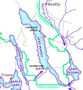
English: The Lake Manly lake system as it might have looked during its last maximum extent 22,000 years ago. (USGS image). The Lake Manly lake system as it might have looked during its last maximum extent 22,000 years ago. Arrows indicate river water flow, gray lines are current highways, and red dots are towns. (USGS image). The Lake Manly lake system as it might have looked during its last maximum extent 22,000 years ago. (USGS image).
Français : Le Lac Manly tel qu'il devait être à son extension maximale, il y a 22 000 années. (Document de l'USGS).
Magyar: A Manly-tó és a környező vízrendszer kb. 22 000 évvel ezelőtt.
Български: Най-вероятно така е изглеждала Долината на смъртта преди 22 000 години. |
|||||||||
| Fonte |
Death Valley Geology Field Trip: Shoreline Butte: |
|||||||||
| Licenza (Riusare questo file) |
|
|||||||||
| Geotemporal data | ||||||||||
| Bounding box |
|
|||||||||
| Georeferencing | ||||||||||
| Altre versioni |
|
|||||||||

Cronologia del file
Fare clic su un gruppo data/ora per vedere il file come si presentava nel momento indicato.
| Data/Ora | Miniatura | Dimensioni | Utente | Commento | |
|---|---|---|---|---|---|
| attuale | 19:43, 23 feb 2012 | | 290 × 315 (16 KB) | Ras67 | cropped |
| 10:48, 12 mar 2006 |  | 291 × 316 (17 KB) | Urban~commonswiki | USGS image from http://www2.nature.nps.gov/geology/usgsnps/deva/ftsho1.html<br><br>{{PD-USGov}} Category:Death Valley |
Pagine che usano questo file
La seguente pagina usa questo file:
Utilizzo globale del file
Anche i seguenti wiki usano questo file:
- Usato nelle seguenti pagine di bg.wikipedia.org:
- Usato nelle seguenti pagine di de.wikipedia.org:
- Usato nelle seguenti pagine di fr.wikipedia.org:
- Usato nelle seguenti pagine di he.wikipedia.org:
- Usato nelle seguenti pagine di hu.wikipedia.org:
- Usato nelle seguenti pagine di zh.wikipedia.org: