File:Lasvegas.terra.1500pix.jpg
File originale (1 500 × 1 256 pixel, dimensione del file: 199 KB, tipo MIME: image/jpeg)
| Questo file e la sua pagina di descrizione (discussione · modifica) si trovano su Wikimedia Commons (?) |

|
Questo file è stato trasferito su Wikimedia Commons da en.wikipedia utilizzando uno script per bot. Tutte le informazioni riguardanti la fonte del file sono ancora presenti. Tuttavia, necessitano di un controllo umano. Inoltre, potrebbero esserci degli errori nella visualizzazione di tutte le informazioni del file, dovuti alle differenze esistenti fra i template dei progetti Wikimedia. Di conseguenza, le informazioni su questo file non dovrebbero essere considerate attendibili e il file non dovrebbe essere riutilizzato finché non è stato controllato e finché tutte le correzioni necessarie non sono state fatte. Una volta eseguito il controllo, per favore rimuovi questo avviso. Per maggiori dettagli, vedi sotto. Controlla adesso! |
| Descrizione |
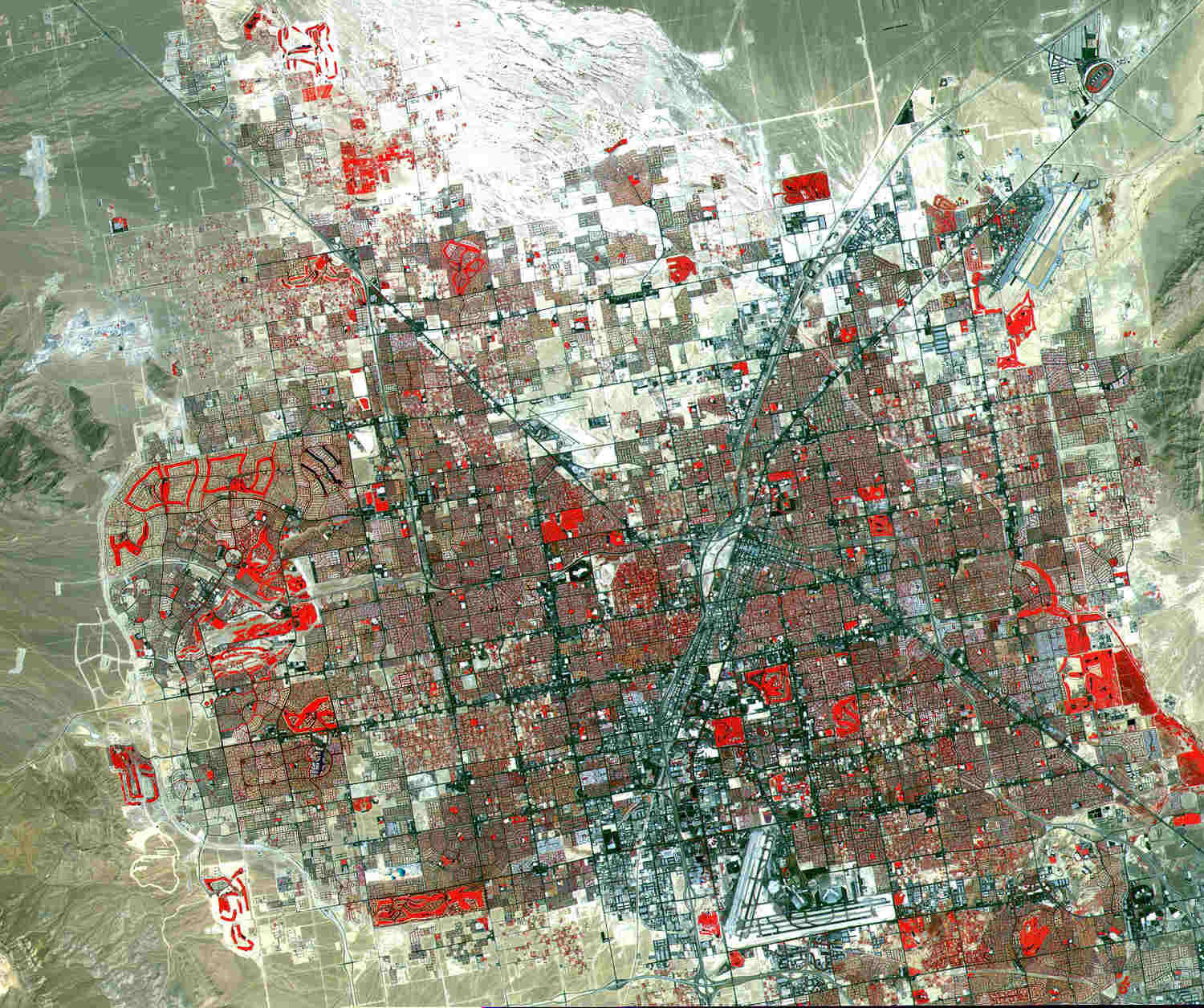
English: This image of Las Vegas, Nevada, was acquired on August, 2000, and covers an area 42 km (25 miles) wide and 30 km (18 miles) long. The image displays three bands of the reflected visible and infrared wavelength region, with a spatial resolution of 15 meters. McCarran International Airport to the south and Nellis Air Force Base to the northeast are the two major airports visible. Golf courses appear as bright red meanders of grass-covered land. The first settlement in Las Vegas (which is Spanish for “The Meadows”) was recorded back in the early 1850s when The Church of Jesus Christ of Latter-day Saints, headed by Brigham Young, sent a mission of thirty men to construct a fort and teach agriculture to the Indians. Las Vegas became a city in 1905 when the railroad announced this city was to be a major division point. Prior to legalized gambling in 1931, Las Vegas was developing as an agricultural area. Las Vegas’ fame as a resort area became prominent after World War II. |
| Data | |
| Fonte |
SOURCE: "The purpose of NASA's Earth Observatory is to provide a freely-accessible publication on the Internet where the public can obtain new satellite imagery and scientific information about our home planet. The focus is on Earth's climate and environmental change. In particular, we hope our site is useful to public media and educators. Any and all materials published on the Earth Observatory are freely available for re-publication or re-use, except where copyright is indicated. We ask that NASA's Earth Observatory be given credit for its original materials." Picture prepared for Wikipedia by Adrian Pingstone, November 2003.) |
| Autore |
Image courtesy NASA/GSFC/MITI/ERSDAC/JAROS, and U.S./Japan ASTER Science Team. |
Licenza
| Questo file è nel pubblico dominio perché creato dalla NASA. La politica sul copyright della NASA afferma che «il materiale della NASA non è protetto da copyright a meno che non sia specificato altrimenti». (NASA copyright policy e JPL Image Use Policy). | ||
 |
Attenzione:
|
Registro originale del caricamento
- 2003-11-06 10:40 Arpingstone 1500×1256× (203761 bytes) Las Vegas
Cronologia del file
Fare clic su un gruppo data/ora per vedere il file come si presentava nel momento indicato.
| Data/Ora | Miniatura | Dimensioni | Utente | Commento | |
|---|---|---|---|---|---|
| attuale | 15:12, 12 gen 2010 | | 1 500 × 1 256 (199 KB) | File Upload Bot (Magnus Manske) | {{BotMoveToCommons|en.wikipedia|year={{subst:CURRENTYEAR}}|month={{subst:CURRENTMONTHNAME}}|day={{subst:CURRENTDAY}}}} {{Information |Description={{en|This image of Las Vegas, Nevada, was acquired on August, 2000, and covers an area 42 km (25 miles) wide |
Pagine che usano questo file
Nessuna pagina utilizza questo file.
Utilizzo globale del file
Anche i seguenti wiki usano questo file:
- Usato nelle seguenti pagine di arz.wikipedia.org:
- Usato nelle seguenti pagine di en.wikipedia.org:
- Usato nelle seguenti pagine di fa.wikipedia.org:
- Usato nelle seguenti pagine di gl.wikipedia.org:
- Usato nelle seguenti pagine di hy.wikipedia.org:
- Usato nelle seguenti pagine di ja.wikipedia.org:
- Usato nelle seguenti pagine di pt.wikipedia.org:
- Usato nelle seguenti pagine di simple.wikipedia.org: