File:Le Castellet circuit map Formula One 2018 without corner names English 29 06 2021.svg

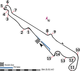
Dimensioni di questa anteprima PNG per questo file SVG: 673 × 599 pixel. Altre risoluzioni: 270 × 240 pixel | 539 × 480 pixel | 863 × 768 pixel | 1 150 × 1 024 pixel | 2 300 × 2 048 pixel | 2 191 × 1 951 pixel.
File originale (file in formato SVG, dimensioni nominali 2 191 × 1 951 pixel, dimensione del file: 59 KB)
| Questo file e la sua pagina di descrizione (discussione · modifica) si trovano su Wikimedia Commons (?) |
Dettagli
| Descrizione |
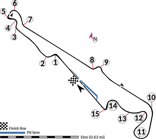
English: This is an altered version of File:Le Castellet circuit map Formula One 2018 without corner names June 2021.svg with the key solely in English and a few other alterations. This is a map of the Le Castellet motor circuit as it was used by w:en:Formula One for the w:en:2018 French Grand Prix, before the pit lane entrances and exits were reconfigured, and includes corner numbers and other information sourced from the FIA's map of the circuit. This map is valid for races which use this layout and corner numbering scheme, please upload a new file for races which use different layouts or corner numbering schemes rather than replacing this file. As this is a free-hand map drawn by an enthusiast rather than a professional cartographer's work it may contain some errors, although checking it against other maps it appears accurate enough for most purposes. The track is shown in black with a grey outline, while the pit lane is shown in blue. A scale showing the length of one kilometre (with increments of 100 metres) is given, to allow viewers to contextualise and understand what they are looking at. Corner numbers and other important text is given an off-white background to avoid transparency issues rendering it illegible on certain devices. A thick white line covering the track and the pit lane, marked with a chequered flag, shows the location of the start/finish line, also known as the control or timing line. A thinner white line, covering only the track, shows the location of pole position, and is marked with a large black arrow indicating the direction of travel. There are also thin white lines crossing the track which indicate the ends of the first and second timing sectors used by Formula One; these are marked with smaller black arrows, which also indicate the direction of travel. The mauve arrow marked "N" shows the direction of north.
Arrow pointing north Pit lane Links corner number to location of corner |
| Data | |
| Fonte | Opera propria |
| Autore | HumanBodyPiloter5 |
| Altre versioni |
   |
Licenza
Io, detentore del copyright su quest'opera, dichiaro di pubblicarla con la seguente licenza:
| Questo file è reso disponibile nei termini della licenza Creative Commons CC0 1.0 Universal. | |
| La persona che ha associato un'opera con questo atto legale ha donato tale opera nel pubblico dominio rinunciando a tutti i diritti sull'opera in tutto il mondo, inclusi tutti i diritti connessi o altri diritti simili, per quanto permesso dalla legge. Puoi copiare, modificare, distribuire ed utilizzare l'opera, anche a fini commerciali, senza chiedere alcun permesso.
|
Cronologia del file
Fare clic su un gruppo data/ora per vedere il file come si presentava nel momento indicato.
| Data/Ora | Miniatura | Dimensioni | Utente | Commento | |
|---|---|---|---|---|---|
| attuale | 03:15, 29 giu 2021 | | 2 191 × 1 951 (59 KB) | HumanBodyPiloter5 | Uploaded own work with UploadWizard |
Pagine che usano questo file
La seguente pagina usa questo file:
Utilizzo globale del file
Anche i seguenti wiki usano questo file:
- Usato nelle seguenti pagine di af.wikipedia.org:
- Usato nelle seguenti pagine di en.wikipedia.org:
- Usato nelle seguenti pagine di fi.wikipedia.org:
- Usato nelle seguenti pagine di fr.wikipedia.org:
- Usato nelle seguenti pagine di fy.wikipedia.org:
- Usato nelle seguenti pagine di gl.wikipedia.org:
- Usato nelle seguenti pagine di hr.wikipedia.org:
- Usato nelle seguenti pagine di hu.wikipedia.org:
- Usato nelle seguenti pagine di id.wikipedia.org:
- Usato nelle seguenti pagine di pl.wikipedia.org:
- Usato nelle seguenti pagine di ro.wikipedia.org:
- Usato nelle seguenti pagine di tr.wikipedia.org: