File:NUTS 3 regions of North East England map.svg

Dimensioni di questa anteprima PNG per questo file SVG: 482 × 599 pixel. Altre risoluzioni: 193 × 240 pixel | 386 × 480 pixel | 618 × 768 pixel | 824 × 1 024 pixel | 1 647 × 2 048 pixel | 1 082 × 1 345 pixel.
File originale (file in formato SVG, dimensioni nominali 1 082 × 1 345 pixel, dimensione del file: 714 KB)
| Questo file e la sua pagina di descrizione (discussione · modifica) si trovano su Wikimedia Commons (?) |
Dettagli
| Descrizione |
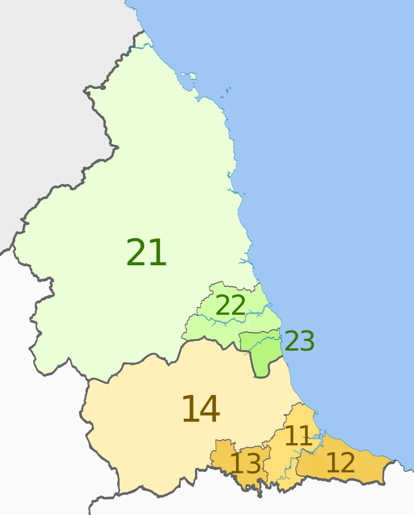
English: Map of the NUTS 3 regions of North East England.
Equirectangular map projection on WGS 84 datum, with N/S stretched 170% Geographic limits:
|
| Data | (UTC) |
| Fonte |
Questo file deriva da: |
| Autore |
|


| NUTS 1 | Code | NUTS 2 | Code | NUTS 3 | Code |
|---|---|---|---|---|---|
| North East, England | UKC | Tees Valley and Durham | UKC1 | Hartlepool and Stockton-on-Tees | UKC11 |
| South Teesside (Middlesbrough and Redcar and Cleveland) | UKC12 | ||||
| Darlington | UKC13 | ||||
| Durham | UKC14 | ||||
| Northumberland and Tyne and Wear | UKC2 | ||||
| Northumberland | UKC21 | ||||
| Tyneside (Newcastle upon Tyne, Gateshead, South Tyneside, North Tyneside) | UKC22 | ||||
| Sunderland | UKC23 |
Licenza
Questo file è disponibile in base alla licenza Creative Commons Attribuzione-Condividi allo stesso modo 3.0 Unported
Attribuzione: Dr Greg and Nilfanion. Contains Ordnance Survey data © Crown copyright and database right 2011
- Tu sei libero:
- di condividere – di copiare, distribuire e trasmettere quest'opera
- di modificare – di adattare l'opera
- Alle seguenti condizioni:
- attribuzione – Devi fornire i crediti appropriati, un collegamento alla licenza e indicare se sono state apportate modifiche. Puoi farlo in qualsiasi modo ragionevole, ma non in alcun modo che suggerisca che il licenziante approvi te o il tuo uso.
- condividi allo stesso modo – Se remixi, trasformi o sviluppi il materiale, devi distribuire i tuoi contributi in base alla stessa licenza o compatibile all'originale.
Registro originale del caricamento
This image is a derivative work of the following images:
- File:North_East_England__districts_2011_map.svg licensed with Cc-by-sa-3.0, GFDL
- 2011-05-01T18:56:43Z Nilfanion 1082x1345 (714062 Bytes) == Summary == {{Information |Description=Map of the [[w:North East England|North East England]] region showing the administrative districts. Equirectangular map projection on WGS 84 datum, with N/S stretched 170% Geographic
- File:English_ceremonial_counties_2010.svg licensed with Cc-by-sa-3.0, GFDL
- 2010-11-23T16:39:55Z Nilfanion 1108x1345 (308868 Bytes) thicker lines
- 2010-11-23T16:20:19Z Nilfanion 1108x1345 (301520 Bytes) tweaks
- 2010-10-26T20:34:20Z Nilfanion 817x990 (1391832 Bytes) {{Information |Description=Map showing the [[w:ceremonial counties of England]] including the City of London, in 2010. Equirectangular map projection on WGS 84 datum, with N/S stretched 170% Geographic limits: *West: 6.75W
Uploaded with derivativeFX
Cronologia del file
Fare clic su un gruppo data/ora per vedere il file come si presentava nel momento indicato.
| Data/Ora | Miniatura | Dimensioni | Utente | Commento | |
|---|---|---|---|---|---|
| attuale | 23:27, 4 giu 2012 | | 1 082 × 1 345 (714 KB) | Dr Greg | == {{int:filedesc}} == {{Information |Description=Map of the NUTS 3 regions of North East England. Equirectangular map projection on WGS 84 datum, with N/S stretched 170... |
Pagine che usano questo file
La seguente pagina usa questo file:
Utilizzo globale del file
Anche i seguenti wiki usano questo file:
- Usato nelle seguenti pagine di bn.wikipedia.org:
- Usato nelle seguenti pagine di de.wikipedia.org:
- Usato nelle seguenti pagine di en.wikipedia.org:
- Usato nelle seguenti pagine di fi.wikipedia.org:
- Usato nelle seguenti pagine di lt.wikipedia.org:
- Usato nelle seguenti pagine di ru.wikipedia.org:
- Usato nelle seguenti pagine di zh.wikipedia.org: