File:Northern central British Isles c 700.gif
Dimensioni di questa anteprima: 697 × 599 pixel. Altre risoluzioni: 279 × 240 pixel | 558 × 480 pixel | 979 × 842 pixel.
File originale (979 × 842 pixel, dimensione del file: 407 KB, tipo MIME: image/gif)
| Questo file e la sua pagina di descrizione (discussione · modifica) si trovano su Wikimedia Commons (?) |
Dettagli

|
Questo file è stato trasferito su Wikimedia Commons da en.wikipedia utilizzando uno script per bot. Tutte le informazioni riguardanti la fonte del file sono ancora presenti. Tuttavia, necessitano di un controllo umano. Inoltre, potrebbero esserci degli errori nella visualizzazione di tutte le informazioni del file, dovuti alle differenze esistenti fra i template dei progetti Wikimedia. Di conseguenza, le informazioni su questo file non dovrebbero essere considerate attendibili e il file non dovrebbe essere riutilizzato finché non è stato controllato e finché tutte le correzioni necessarie non sono state fatte. Una volta eseguito il controllo, per favore rimuovi questo avviso. Per maggiori dettagli, vedi sotto. Controlla adesso! |
| Descrizione |
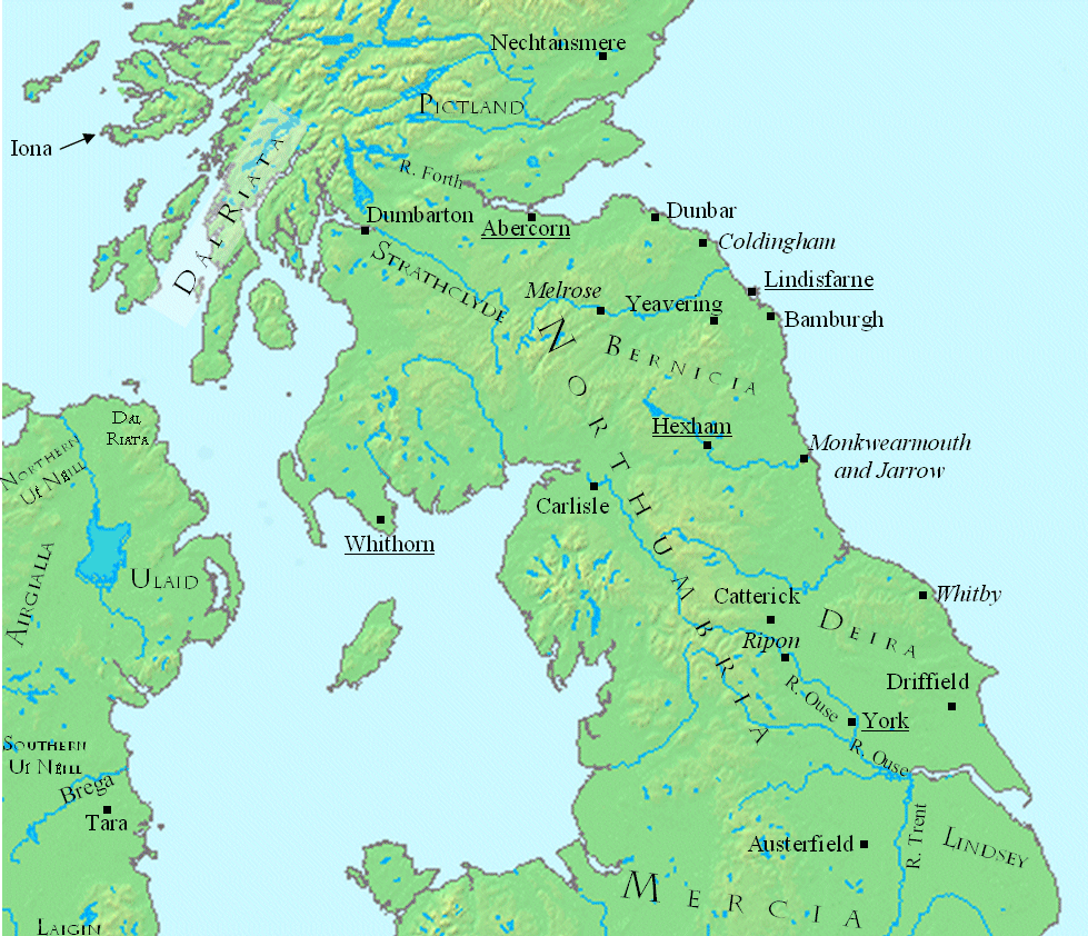
English: This is a map showing the north central British Isles in the late seventh century.
The file was created using DMIS. On that site it is stated that "We do not claim copyright on the images, so you can use them for Wikipedia." Sources include (for Great Britain) a map found in Peter Hunter Blair's "Roman Britain and Early England: 55 B.C.-871 A.D.", W.W. Norton, 1963, p. 209; and (for Ireland) on a map in Duffy's Atlas of Irish History. |
| Data | 10 febbraio 2008 (data di caricamento originaria) |
| Fonte | Trasferito da en.wikipedia su Commons da CatMan61 utilizzando CommonsHelper. |
| Autore | Mike Christie di Wikipedia in inglese |
Licenza
| Quest'opera è stata rilasciata nel pubblico dominio dal suo autore, Mike Christie di Wikipedia in inglese. Questa norma si applica in tutto il mondo. In alcuni paesi questo potrebbe non essere legalmente possibile. In tal caso: Mike Christie garantisce a chiunque il diritto di utilizzare quest'opera per qualsiasi scopo, senza alcuna condizione, a meno che tali condizioni siano richieste dalla legge. |
Registro originale del caricamento
La pagina di descrizione originale era qui. Tutti i nomi utente che seguono sono riferiti a en.wikipedia.
- 2008-02-10 22:41 Mike Christie 979×842× (416474 bytes) Move Strathclyde
- 2008-02-10 22:39 Mike Christie 979×843× (417411 bytes) Move Strathclyde further northeast
- 2008-02-10 20:43 Mike Christie 979×843× (418441 bytes) Move Strathclyde to the Clyde valley
- 2008-02-10 17:08 Mike Christie 981×842× (418505 bytes) Typo fix: Firth -> Forth
- 2008-02-10 16:44 Mike Christie 981×844× (419828 bytes) Move Strathclyde
- 2008-02-10 16:41 Mike Christie 979×843× (417131 bytes) Move Strathclyde a bit
- 2008-02-10 16:33 Mike Christie 980×843× (417179 bytes) Change Forfar -> Nechtansmere
- 2008-02-10 15:36 Mike Christie 980×842× (420235 bytes) This is a map showing the north central British Isles in the late seventh century. The file was created using [http://www.demis.nl/home/pages/home.htm DMIS]. On that site it is [http://support.demis.nl/forums/thread/1295.aspx stated] that "We do not cla
Cronologia del file
Fare clic su un gruppo data/ora per vedere il file come si presentava nel momento indicato.
| Data/Ora | Miniatura | Dimensioni | Utente | Commento | |
|---|---|---|---|---|---|
| attuale | 06:21, 3 gen 2012 | | 979 × 842 (407 KB) | OgreBot | (BOT): Reverting to most recent version before archival |
| 06:21, 3 gen 2012 |  | 979 × 843 (408 KB) | OgreBot | (BOT): Uploading old version of file from en.wikipedia; originally uploaded on 2008-02-10 22:39:02 by Mike Christie | |
| 06:21, 3 gen 2012 |  | 979 × 843 (409 KB) | OgreBot | (BOT): Uploading old version of file from en.wikipedia; originally uploaded on 2008-02-10 20:43:53 by Mike Christie | |
| 06:20, 3 gen 2012 |  | 981 × 842 (409 KB) | OgreBot | (BOT): Uploading old version of file from en.wikipedia; originally uploaded on 2008-02-10 17:08:54 by Mike Christie | |
| 06:20, 3 gen 2012 |  | 981 × 844 (410 KB) | OgreBot | (BOT): Uploading old version of file from en.wikipedia; originally uploaded on 2008-02-10 16:44:14 by Mike Christie | |
| 06:20, 3 gen 2012 |  | 979 × 843 (407 KB) | OgreBot | (BOT): Uploading old version of file from en.wikipedia; originally uploaded on 2008-02-10 16:41:23 by Mike Christie | |
| 06:20, 3 gen 2012 |  | 980 × 843 (407 KB) | OgreBot | (BOT): Uploading old version of file from en.wikipedia; originally uploaded on 2008-02-10 16:33:49 by Mike Christie | |
| 06:20, 3 gen 2012 |  | 980 × 842 (410 KB) | OgreBot | (BOT): Uploading old version of file from en.wikipedia; originally uploaded on 2008-02-10 15:36:41 by Mike Christie | |
| 15:19, 2 gen 2012 |  | 979 × 842 (407 KB) | File Upload Bot (Magnus Manske) | {{BotMoveToCommons|en.wikipedia|year={{subst:CURRENTYEAR}}|month={{subst:CURRENTMONTHNAME}}|day={{subst:CURRENTDAY}}}} {{Information |Description={{en|This is a map showing the north central British Isles in the late seventh century. The file was create |
Pagine che usano questo file
La seguente pagina usa questo file:
Utilizzo globale del file
Anche i seguenti wiki usano questo file:
- Usato nelle seguenti pagine di arz.wikipedia.org:
- Usato nelle seguenti pagine di de.wikipedia.org:
- Usato nelle seguenti pagine di el.wikipedia.org:
- Usato nelle seguenti pagine di en.wikipedia.org:
- Usato nelle seguenti pagine di fr.wikipedia.org: