File:Photograph of the Red Buttes - NARA - 516886.tif

File originale (3 000 × 2 283 pixel, dimensione del file: 6,53 MB, tipo MIME: image/tiff)
| Questo file e la sua pagina di descrizione (discussione · modifica) si trovano su Wikimedia Commons (?) |
Dettagli
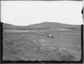
| Photograph of the Red Buttes
( |
|||||||||||||||||||||||||||
|---|---|---|---|---|---|---|---|---|---|---|---|---|---|---|---|---|---|---|---|---|---|---|---|---|---|---|---|
| Autore |
|
||||||||||||||||||||||||||
| Record creator | Department of the Interior. General Land Office. U.S. Geological and Geographic Survey of the Territories. (1874 - 06/30/1879) | ||||||||||||||||||||||||||
| Titolo |
Photograph of the Red Buttes |
||||||||||||||||||||||||||
| Descrizione |
|
||||||||||||||||||||||||||
| Data | 1870 | ||||||||||||||||||||||||||
| Collezione |
|
||||||||||||||||||||||||||
| Record ID |
Search Identifier: siEyewitness Exhibit
|
||||||||||||||||||||||||||
| Fonte | U.S. National Archives and Records Administration | ||||||||||||||||||||||||||
| Altre versioni |
Please do not overwrite this file: any cropping or other restoration work should be uploaded with a new name and linked in this page's "other versions=" parameter, so that this file represents the exact file found in the NARA catalog record to which it links. The metadata on this page was imported directly from NARA's catalog record; additional descriptive text may be added by Wikimedians to the template below with the "description=" parameter, but please do not modify the other fields. tradurre
|
||||||||||||||||||||||||||


Licenza
This file was provided to Wikimedia Commons by the National Archives and Records Administration as part of a cooperation project. The National Archives and Records Administration provides images depicting American and global history which are public domain or licensed under a free license.
|
Quest'opera è nel pubblico dominio negli Stati Uniti d'America poiché è opera del Governo Federale degli Stati Uniti secondo i termini del titolo 17, capitolo 1, sezione 105 del Codice USA. Vedi anche Copyright per maggiori informazioni.
Nota: la norma si applica solo ad opere prodotte dal governo federale e non dai singoli stati, territori, commonwealth, contee, suddivisioni, municipalità o qualsiasi altra suddivisione degli Stati Uniti. Non si applica inoltre ai francobolli pubblicati dallo United States Postal Service fino al 1978 (vedi 206.02(b) of Compendium II: Copyright Office Practices).
|
 | |
| Questo file è stato identificato come libero da restrizioni conosciute riguardanti le leggi sul copyright, compresi tutti i diritti connessi e vicini. | ||
Cronologia del file
Fare clic su un gruppo data/ora per vedere il file come si presentava nel momento indicato.
| Data/Ora | Miniatura | Dimensioni | Utente | Commento | |
|---|---|---|---|---|---|
| attuale | 23:22, 24 set 2011 |  | 3 000 × 2 283 (6,53 MB) | US National Archives bot | == {{int:filedesc}} == {{NARA-image-full |Title=Photograph of the Red Buttes |Scope and content=Original caption: View of the Red Buttes at what is now known as Bessemer Bend, a notable point of the old Oregon Trail where the Oregon Trail left the North |
Pagine che usano questo file
La seguente pagina usa questo file: