File:Qing Empire circa 1820 EN.svg

Dimensioni di questa anteprima PNG per questo file SVG: 686 × 600 pixel. Altre risoluzioni: 275 × 240 pixel | 549 × 480 pixel | 879 × 768 pixel | 1 172 × 1 024 pixel | 2 343 × 2 048 pixel | 849 × 742 pixel.
File originale (file in formato SVG, dimensioni nominali 849 × 742 pixel, dimensione del file: 548 KB)
| Questo file e la sua pagina di descrizione (discussione · modifica) si trovano su Wikimedia Commons (?) |

|
This file requires updating because: The island of Sumatra as depicted on the small globe in the lower left is colliding with Atlantis (Tuva?) and a peninsula unknown to modern geography is extending off the western coast of India. The eastern coast of Taiwan was never under the sovereignty of the Qing Empire. In doing so, you could add a timestamp to the file.
|
Dettagli
| Descrizione |
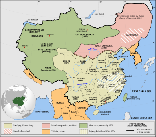
English: Qing Empire c. 1820 |
| Data | |
| Fonte | Opera propria Incorporates modified version of File:Empire of the Great Qing (orthographic projection).svg. Note that the map excludes Tawang from Tibet. |
| Autore | Philg88: Attribution Wikimedia Foundation, www.wikimedia.org |
.svg)
Licenza
Questo file è disponibile in base alla licenza Creative Commons Attribuzione 4.0 Internazionale
- Tu sei libero:
- di condividere – di copiare, distribuire e trasmettere quest'opera
- di modificare – di adattare l'opera
- Alle seguenti condizioni:
- attribuzione – Devi fornire i crediti appropriati, un collegamento alla licenza e indicare se sono state apportate modifiche. Puoi farlo in qualsiasi modo ragionevole, ma non in alcun modo che suggerisca che il licenziante approvi te o il tuo uso.
Cronologia del file
Fare clic su un gruppo data/ora per vedere il file come si presentava nel momento indicato.
| Data/Ora | Miniatura | Dimensioni | Utente | Commento | |
|---|---|---|---|---|---|
| attuale | 22:03, 13 giu 2021 | | 849 × 742 (548 KB) | SSH remoteserver | Reverted to version as of 03:34, 13 June 2021 (UTC) |
| 20:31, 13 giu 2021 |  | 849 × 742 (548 KB) | SSH remoteserver | Reverted to version as of 00:04, 13 June 2021 (UTC) | |
| 05:34, 13 giu 2021 |  | 849 × 742 (548 KB) | NorthTension | Reverted to version as of 07:44, 15 December 2020 (UTC) | |
| 02:04, 13 giu 2021 |  | 849 × 742 (548 KB) | SSH remoteserver | Burma was not a tributary. Please See: A Disguised Defeat https://www.jstor.org/stable/3876499; and Burmese Chronicles | |
| 09:44, 15 dic 2020 |  | 849 × 742 (548 KB) | LiliCharlie | Reverted to version as of 21:26, 10 October 2020 (UTC) — that's an embedded bitmap rather than a vector image — as Bidgee said, if you dispute it, upload under a new file name, perhaps as a PNG file | |
| 09:13, 15 dic 2020 |  | 1 172 × 1 024 (509 KB) | Бмхүн | Reverted to version as of 10:04, 24 March 2020 (UTC) | |
| 23:26, 10 ott 2020 |  | 849 × 742 (548 KB) | Bidgee | Reverted to version as of 16:15, 29 April 2014 (UTC) if you dispute it, upload under a new file per COM:OVERWRITE | |
| 13:00, 4 ott 2020 |  | 1 172 × 1 024 (509 KB) | Бмхүн | The oldest version has too much wrong,such as Guizhou should be Guangxi, Caton isn’t Guangdong, and manchus homeland located in south part of Manchuria | |
| 18:54, 23 giu 2020 |  | 849 × 742 (548 KB) | LiliCharlie | Reverted embedded bitmap version to true vector version as of 16:15, 29 April 2014 (UTC) | |
| 12:04, 24 mar 2020 |  | 1 172 × 1 024 (509 KB) | Anchuhu | Reverted to version as of 06:35, 9 January 2019 (UTC) the borders and provinces name are wrong |
Pagine che usano questo file
La seguente pagina usa questo file:
Utilizzo globale del file
Anche i seguenti wiki usano questo file:
- Usato nelle seguenti pagine di ar.wikipedia.org:
- Usato nelle seguenti pagine di cdo.wikipedia.org:
- Usato nelle seguenti pagine di cs.wikipedia.org:
- Usato nelle seguenti pagine di da.wikipedia.org:
- Usato nelle seguenti pagine di de.wikipedia.org:
- Usato nelle seguenti pagine di el.wikipedia.org:
- Usato nelle seguenti pagine di en.wikipedia.org:
- China
- History of China
- History of Asia
- Imperialism
- History of East Asia
- Taiping Rebellion
- Manchu people
- History of Tibet
- Treaty of Nerchinsk
- Portal:China
- Portal:Asia
- History of Mongolia
- Amur Annexation
- Transition from Ming to Qing
- Settler colonialism
- Talk:Qing dynasty/Archive 5
- Tibet under Qing rule
- Xinjiang under Qing rule
- List of modern great powers
- Timeline of the Qing dynasty
- User:Falcaorib
- Talk:COVID-19 pandemic/Archive 2
- User talk:FuzionEXA
- User:Sanskar shingare/sandbox
- Usato nelle seguenti pagine di es.wikipedia.org:
- Usato nelle seguenti pagine di et.wikipedia.org:
- Usato nelle seguenti pagine di fa.wikipedia.org:
- Usato nelle seguenti pagine di fr.wikipedia.org:
Visualizza l'utilizzo globale di questo file.