File:SaintPierre1772.png

Dimensioni di questa anteprima: 800 × 362 pixel. Altre risoluzioni: 320 × 145 pixel | 640 × 290 pixel | 1 105 × 500 pixel.
File originale (1 105 × 500 pixel, dimensione del file: 450 KB, tipo MIME: image/png)
| Questo file e la sua pagina di descrizione (discussione · modifica) si trovano su Wikimedia Commons (?) |
Dettagli
| Descrizione |
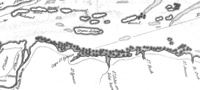
English: This is a detail from the source map, which is titled as follows: River St. Lawrence from Montréal to the Island of St. Barnaby... and the Island of Jeremy.
This detail shows a portion of the Saint Lawrence River east of Quebec City, showing locations of note in the March 1776 Battle of Saint-Pierre: Crane Island (Île-aux-Grues), St. Anne's (St.-Anne-de-la-Pocatiere), St. Thomas, and St. Peter (Saint-Pierre). |
|||||||||||||||||||
| Data | ||||||||||||||||||||
| Fonte |
URL at time of upload: http://services.banq.qc.ca/sdx/cep/document.xsp?app=ca.BAnQ.sdx.cep&db=notice&id=0002663585&n=9&dbrf0=xtgpleintexte_fr_FR&dbrv0=lawrence&sBtn=Lancer&qlang=fr-FR&db=notice&dbrn=1&sortfield=titre_trie&order=ascendant&col=america&chpp=20&dbrqp=search_notice&qid=sdx_q0 |
|||||||||||||||||||
| Autore |
|
|||||||||||||||||||

Licenza
|
Quest'opera è nel pubblico dominio anche in tutti i Paesi e nelle aree in cui la durata del copyright è la vita dell'autore più 100 anni o meno. | |
| Questo file è stato identificato come libero da restrizioni conosciute riguardanti le leggi sul copyright, compresi tutti i diritti connessi e vicini. | |
Cronologia del file
Fare clic su un gruppo data/ora per vedere il file come si presentava nel momento indicato.
| Data/Ora | Miniatura | Dimensioni | Utente | Commento | |
|---|---|---|---|---|---|
| attuale | 04:24, 13 feb 2009 | | 1 105 × 500 (450 KB) | Magicpiano | {{Information |Description={{en|1=This is a detail from the source map, which is titled as follows: River St. Lawrence from Montréal to the Island of St. Barnaby... and the Island of Jeremy. This detail shows a portion of the Saint Lawrence River east o |
Pagine che usano questo file
La seguente pagina usa questo file:
Utilizzo globale del file
Anche i seguenti wiki usano questo file:
- Usato nelle seguenti pagine di en.wikipedia.org:
- Usato nelle seguenti pagine di fr.wikipedia.org:
- Usato nelle seguenti pagine di ja.wikipedia.org:
- Usato nelle seguenti pagine di nl.wikipedia.org: