File:Track map for the Pau street circuit -- 2007.svg

Dimensioni di questa anteprima PNG per questo file SVG: 800 × 552 pixel. Altre risoluzioni: 320 × 221 pixel | 640 × 442 pixel | 1 024 × 707 pixel | 1 280 × 884 pixel | 2 560 × 1 767 pixel | 1 424 × 983 pixel.
File originale (file in formato SVG, dimensioni nominali 1 424 × 983 pixel, dimensione del file: 189 KB)
| Questo file e la sua pagina di descrizione (discussione · modifica) si trovano su Wikimedia Commons (?) |
Dettagli
| Descrizione |
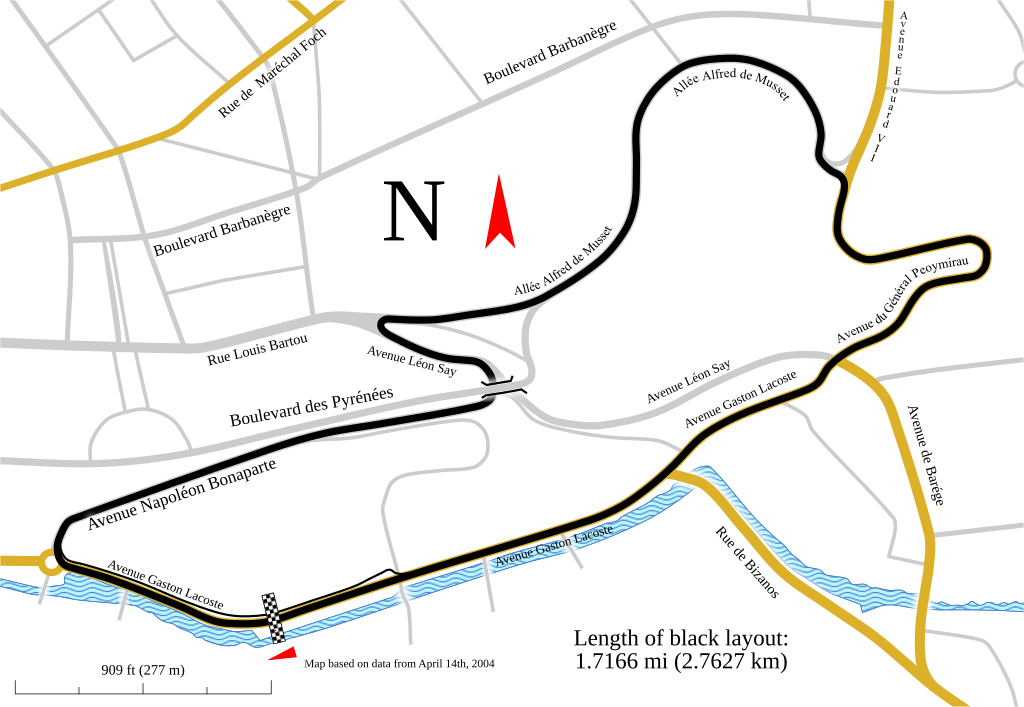
English: Track map for use with Pau Grand Prix. This version shows the track as it was in 2007.
Notes:
|
| Data | |
| Fonte | Opera propria |
| Autore | Will Pittenger |
| Altre versioni |
Older images by other authors for the same track
Same map, but with different data
|

![]]](http://commons.wikimedia.org/wiki/File:Track_map_for_the_Pau_street_circuit_--_2007.svg)
Questa grafica vettoriale non specificata secondo il W3C è stata creata con Inkscape .
| Luogo dello scatto | | Posizione di questa e altre immagini su: OpenStreetMap |
|---|
Licenza
Io, detentore del copyright su quest'opera, dichiaro di pubblicarla con la seguente licenza:
Questo file è disponibile in base alla licenza Creative Commons Attribuzione-Condividi allo stesso modo 3.0 Unported
- Tu sei libero:
- di condividere – di copiare, distribuire e trasmettere quest'opera
- di modificare – di adattare l'opera
- Alle seguenti condizioni:
- attribuzione – Devi fornire i crediti appropriati, un collegamento alla licenza e indicare se sono state apportate modifiche. Puoi farlo in qualsiasi modo ragionevole, ma non in alcun modo che suggerisca che il licenziante approvi te o il tuo uso.
- condividi allo stesso modo – Se remixi, trasformi o sviluppi il materiale, devi distribuire i tuoi contributi in base alla stessa licenza o compatibile all'originale.
Cronologia del file
Fare clic su un gruppo data/ora per vedere il file come si presentava nel momento indicato.
| Data/Ora | Miniatura | Dimensioni | Utente | Commento | |
|---|---|---|---|---|---|
| attuale | 05:29, 12 feb 2010 | | 1 424 × 983 (189 KB) | Will Pittenger | The version being reverted is for editing purposes. This version is the viewable verison |
| 05:28, 12 feb 2010 |  | 1 424 × 983 (121 KB) | Will Pittenger | One of these days... | |
| 05:26, 12 feb 2010 |  | 1 424 × 983 (189 KB) | Will Pittenger | Oops. Previous version already had the text on path objects converted into paths. Since a version online is needed that is editable, I have to upload this version. | |
| 05:22, 12 feb 2010 |  | 1 424 × 983 (189 KB) | Will Pittenger | Found out that pit lane was actually in a different spot and moved it to the correct location. Note: Three text objects are now on paths. This version is for editing only. | |
| 23:06, 6 feb 2010 |  | 1 424 × 983 (287 KB) | Will Pittenger | The text objects that were on paths are now plain paths. If you need to edit this file, please follow the instructions in the description. | |
| 23:00, 6 feb 2010 |  | 1 424 × 983 (120 KB) | Will Pittenger | {{Information |Description={{en|1=Track map for use with w:Pau Grand Prix. This version shows the track as it was in w:2007. Notes: *This map has three text objects on paths. MediaWiki/RSVG has a bug causing it to hide all such objects. Henc |
Pagine che usano questo file
Le seguenti 2 pagine usano questo file:
Utilizzo globale del file
Anche i seguenti wiki usano questo file:
- Usato nelle seguenti pagine di ast.wikipedia.org:
- Usato nelle seguenti pagine di cs.wikipedia.org:
- Usato nelle seguenti pagine di de.wikipedia.org:
- Usato nelle seguenti pagine di en.wikipedia.org:
- Usato nelle seguenti pagine di es.wikipedia.org:
- Usato nelle seguenti pagine di fi.wikipedia.org:
- Usato nelle seguenti pagine di hu.wikipedia.org:
- Usato nelle seguenti pagine di ja.wikipedia.org:
- Usato nelle seguenti pagine di nl.wikipedia.org:
- Usato nelle seguenti pagine di no.wikipedia.org:
- Usato nelle seguenti pagine di pt.wikipedia.org:
- Usato nelle seguenti pagine di ru.wikipedia.org:
- Usato nelle seguenti pagine di sl.wikipedia.org:
- Usato nelle seguenti pagine di www.wikidata.org: