File:Trafalgar 1200hr.gif
Dimensioni di questa anteprima: 635 × 600 pixel. Altre risoluzioni: 254 × 240 pixel | 508 × 480 pixel | 900 × 850 pixel.
File originale (900 × 850 pixel, dimensione del file: 30 KB, tipo MIME: image/gif)
| Questo file e la sua pagina di descrizione (discussione · modifica) si trovano su Wikimedia Commons (?) |

|
Questo file è stato rimpiazzato da File:Trafalgar 1200hr.svg. Si raccomanda di usare l'altro file. Per favore ricorda che la cancellazione di immagini rimpiazzate è soggetta a consenso. Motivo per usare l'altro file: "The new file is SVG, and has less spelling mistakes"
|

|
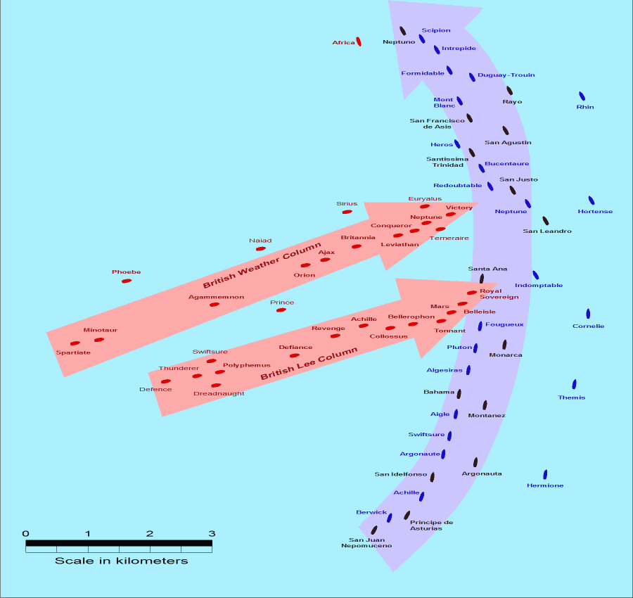
- Description: This map of the Battle of Trafalgar shows the approximate position of the two fleets at 1200 hours during the battle as the Royal Sovereign was breaking into the Franco-Spanish line. North is to the top, and Cape Trafalgar is 10 miles to the northeast.
- Size: 900 × 850 pixels.
- Source: This drawing is based on an illustration in issue number 84 of the Strategy & Tactics magazine The map was made by RJHall using the Campaign Cartographer drawing program, and the image was reduced in size 50% in Paint Shop Pro. Ship icons are not to scale.
Questo file è disponibile in base alla licenza Creative Commons Attribuzione-Condividi allo stesso modo 2.5 Generico
- Tu sei libero:
- di condividere – di copiare, distribuire e trasmettere quest'opera
- di modificare – di adattare l'opera
- Alle seguenti condizioni:
- attribuzione – Devi fornire i crediti appropriati, un collegamento alla licenza e indicare se sono state apportate modifiche. Puoi farlo in qualsiasi modo ragionevole, ma non in alcun modo che suggerisca che il licenziante approvi te o il tuo uso.
- condividi allo stesso modo – Se remixi, trasformi o sviluppi il materiale, devi distribuire i tuoi contributi in base alla stessa licenza o compatibile all'originale.
Cronologia del file
Fare clic su un gruppo data/ora per vedere il file come si presentava nel momento indicato.
| Data/Ora | Miniatura | Dimensioni | Utente | Commento | |
|---|---|---|---|---|---|
| attuale | 16:30, 28 lug 2005 | | 900 × 850 (30 KB) | RJHall | Battle of Trafalgar situation at 1200hr, 21 October 1805. |
Pagine che usano questo file
Nessuna pagina utilizza questo file.
Utilizzo globale del file
Anche i seguenti wiki usano questo file:
- Usato nelle seguenti pagine di fr.wikipedia.org:
- Usato nelle seguenti pagine di ja.wikipedia.org: