File:USGS-PP1661d-fig22.png
Non sono disponibili versioni a risoluzione più elevata.
USGS-PP1661d-fig22.png (340 × 411 pixel, dimensione del file: 500 KB, tipo MIME: image/png)
| Questo file e la sua pagina di descrizione (discussione · modifica) si trovano su Wikimedia Commons (?) |
| Descrizione |
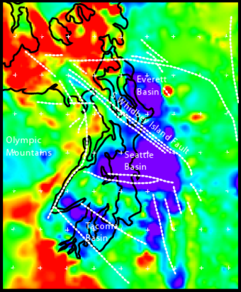
English: Geophysical anomalies and crustal faulting in the Puget Lowland, showing Everett, Tacoma, and Seattle Basins. Bouger gravity anomaly data combined with seismic reflection traveltime data to model rock density at 5 km depth. Blue is the softer, less dense sedimentary deposits, red is the harder, more dense mafic basalt of the Crescent Formation, other colors are intermediate. Black lines are shoreline of Puget Sound, Hood Canal, and the Strait of Juan de Fuca. White dashed lines are crustal faults; faults east of Tacoma Basin are conjectural. |
|||
| Data | Data sconosciuta; approx. 2005. | |||
| Fonte | http://pubs.usgs.gov/pp/pp1661d/pp1661d.pdf | |||
| Autore | U,S. Geological Survey staff | |||
| Licenza (Riusare questo file) |
|
From USGS Professional Paper 1661-D (2005), "Crustal Structure of the Cascadia Fore Arc of Washington", fig. 22, p. 34.
Cronologia del file
Fare clic su un gruppo data/ora per vedere il file come si presentava nel momento indicato.
| Data/Ora | Miniatura | Dimensioni | Utente | Commento | |
|---|---|---|---|---|---|
| attuale | 01:13, 25 apr 2010 | | 340 × 411 (500 KB) | J. Johnson | {{Information |Description={{en|1=Geophysical anomalies and crustal faulting in the Puget Lowland, showing Everett, Tacoma, and Seattle Basins. Bouger gravity anomaly data combined with seismic reflection traveltime data to model rock density at 5 km de |
Pagine che usano questo file
La seguente pagina usa questo file:
Utilizzo globale del file
Anche i seguenti wiki usano questo file:
- Usato nelle seguenti pagine di en.wikipedia.org: