File:Wilderness road en.png

Dimensioni di questa anteprima: 800 × 508 pixel. Altre risoluzioni: 320 × 203 pixel | 640 × 406 pixel | 1 024 × 650 pixel | 1 254 × 796 pixel.
File originale (1 254 × 796 pixel, dimensione del file: 1,74 MB, tipo MIME: image/png)
| Questo file e la sua pagina di descrizione (discussione · modifica) si trovano su Wikimedia Commons (?) |
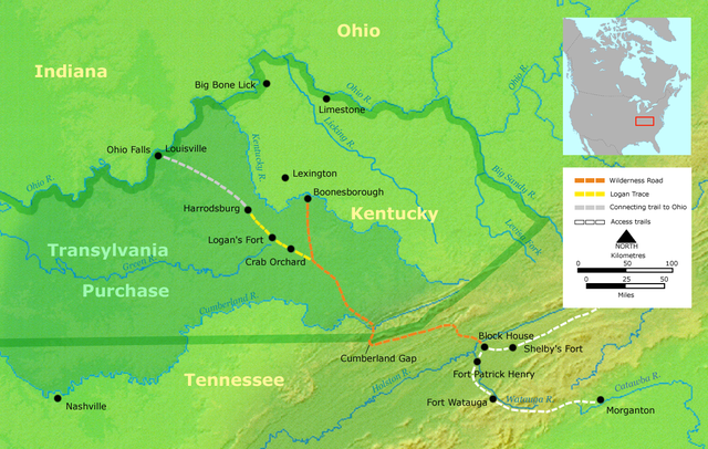
- Description: Course of the Wilderness Road in Kentucky by 2013. Darker green outlines represent the later boundaries of Kentucky, while green shading represents the Transylvania Purchase.
- Source: Own work by Nikater, submitted to the public domain. Background map courtesy of Demis, www.demis.nl.
- Uploader: User:Nikater
- date;14 April 2000
- Other Versions: German Image:Wilderness road_de.png
- License status:
This image is in the public domain because it came from the site https://www.demis.nl/products/web-map-server/examples/ and was released by the copyright holder. Permission is granted to copy, distribute and/or modify this map since it is based on free of copyright images from: www.demis.nl. See also approval email on de.wp and its clarification.
|
| This work has been released into the public domain by its copyright holder, www.demis.nl. This applies worldwide. In alcuni paesi questo potrebbe non essere legalmente possibile. In tal caso: www.demis.nl garantisce a chiunque il diritto di utilizzare quest'opera per qualsiasi scopo, senza alcuna condizione, a meno che tali condizioni siano richieste dalla legge.
|

|
Questa immagine (categorizzazione automatica: map) o tutte le immagini in questa categoria o galleria dovrebbero essere ricreate usando grafica vettoriale come file SVG. Questo offre diversi vantaggi: vedi Commons:Media for cleanup per maggiori informazioni. Se è disponibile una versione in formato SVG di questa immagine, per favore caricala. Dopo aver caricato un file SVG, sostituisci questo avviso con il template {{Vector version available|nome_immagine.svg}}.
|
Cronologia del file
Fare clic su un gruppo data/ora per vedere il file come si presentava nel momento indicato.
| Data/Ora | Miniatura | Dimensioni | Utente | Commento | |
|---|---|---|---|---|---|
| attuale | 21:16, 23 mar 2007 | | 1 254 × 796 (1,74 MB) | Nikater | * Description: Course of the Wilderness Road in Kentucky by 1785 * Source: Own work by Nikater, submitted to the public domain. Background map courtesy of Demis, www.demis.nl. * Uploader: User:Nikater * Date: 23 Mar 2007 * Other Versions: German: Imag |
| 15:24, 21 mar 2007 |  | 1 254 × 796 (1,74 MB) | Nikater | * Description: Course of the Wilderness Road in Kentucky by 1785 * Source: Own work by Nikater, submitted to the public domain. Background map courtesy of Demis, www.demis.nl. * Uploader: User:Nikater * Date: 21 Mar 2007 * Other Versions: German: Imag | |
| 19:17, 18 mar 2007 |  | 1 254 × 796 (1,74 MB) | Nikater | * Description: Course of the Wilderness Road in Kentucky by 1785 * Source: Own work by Nikater, submitted to the public domain. Background map courtesy of Demis, www.demis.nl. * Uploader: User:Nikater * Date: 18 Mar 2007 * Other Versions: German: Imag | |
| 14:13, 17 mar 2007 |  | 1 255 × 760 (1,63 MB) | Nikater | * Description: Course of the Wilderness Road in Kentucky by 1785 * Source: Own work by Nikater, submitted to the public domain. Background map courtesy of Demis, www.demis.nl. * Uploader: User:Nikater * Date: 17 Mar 2007 * Other Versions: German [[Ima |
Pagine che usano questo file
La seguente pagina usa questo file:
Utilizzo globale del file
Anche i seguenti wiki usano questo file:
- Usato nelle seguenti pagine di ar.wikipedia.org:
- Usato nelle seguenti pagine di ca.wikipedia.org:
- Usato nelle seguenti pagine di da.wikipedia.org:
- Usato nelle seguenti pagine di de.wikipedia.org:
- Usato nelle seguenti pagine di en.wikipedia.org:
- Henderson, Kentucky
- Elizabethton, Tennessee
- Clarksville, Tennessee
- American frontier
- Transylvania Colony
- Boonesborough, Kentucky
- Wilderness Road
- Cumberland Gap
- Big Bone, Kentucky
- Richard Henderson (jurist)
- Logan Trace
- Sycamore Shoals
- Cherokee–American wars
- User talk:Kevin1776/Archive 2
- John W. Frazer
- User:Brendan.Hunstad/draft on Cumberland Gap
- User:Drdpw/sandbox2
- Usato nelle seguenti pagine di es.wikipedia.org:
- Usato nelle seguenti pagine di fr.wikipedia.org:
- Usato nelle seguenti pagine di ja.wikipedia.org:
- Usato nelle seguenti pagine di nl.wikipedia.org:
- Usato nelle seguenti pagine di no.wikipedia.org:
- Usato nelle seguenti pagine di pl.wikipedia.org:
- Usato nelle seguenti pagine di ru.wikipedia.org: