File:West Germanic dialect continuum (according to Wiesinger, Heeroma & König).png

File originale(2 836 × 2 749 pixel, dimensione del file: 890 KB, tipo MIME: image/png)

Logo di Commons
Logo di Commons
Questo file e la sua pagina di descrizione (discussione · modifica) si trovano su Wikimedia Commons (?)

Dettagli

Descrizione
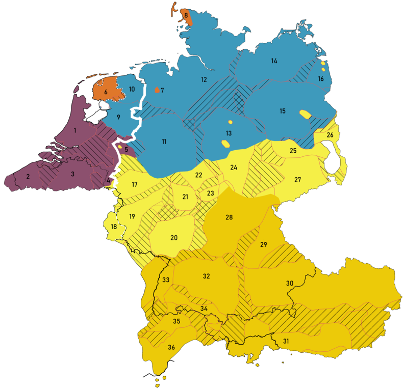
English: A map describing the principal dialect groupings of the closed West Germanic dialect continuum between High German (Middle/Central and Upper German), Low German, Low Franconian and Frisian after 1945.

Based on:

  • Peter Wiesinger [1938–2023]: Die Einteilung der deutschen Dialekte. In: Werner Besch, Ulrich Knoop, Wolfgang Putschke, Herbert Ernst Wiegand (eds.), Dialektologie: Ein Handbuch zur deutschen und allgemeinen Dialektforschung, 2nd subvolume, series: HSK 1.2, Walter de Gruyter, Berlin / New York, 1983, pp. 807–900, esp. "Karte 47.4: Einteilung der deutschen Dialekte: Gliederung der deutschen Dialekte (in den ersten Jahrzehnten des 20. Jhs.)" and "Karte 47.3: Einteilung der deutschen Dialekte: Oberdeutsch, West- und Ostmitteldeutsch, West- und Ostniederdeutsch"
  • Werner König (graphic artist: Hans-Joachim Paul): dtv-Atlas Deutsche Sprache, 19th ed., dtv : München [Munich], 2019, p. 230 [1st ed. 1978, 10th ed. 1994].
  • Jan Goossens: Deutsche Dialektologie, series: Sammlung Göschen 2205, Walter de Gruyter, Berlin / New York, 1977, pp. 48f. (inside section 1. Der Begriff „Deutsche Dialektologie“, subsection 1.2. Was sind deutsche Dialekte?). About a definition of German dialects and for example explaining that
    Sorbisch
    is no German dialect.
  • Wilbert (Jan) Heeringa: Measuring Dialect Pronunciation Differences using Levenshtein Distance, series: Groningen Dissertations in Linguistics 46, doctor's thesis, University of Groningen, 2004, pp. 232–234 inside of Chapter 9: Measuring Dutch dialect distances ([1], [2]). About dialects in the Netherlands and Belgium (and not Germany), but having Central Dutch with a larger extent and having a finer classification, e.g. also having Southwest Limburg (besides Limburg), Urk, East Flanders (besides West Flanders) and Zeeland.
  • Charlotte (Hendrina Elisabeth) Giesbers: Dialecten op de grens van twee talen: een dialectologisch en sociolinguïstisch onderzoek in het Kleverlands dialectgebied, doctor's thesis, Radboud Universiteit Nijmegen, 2008, p. 233 ([3]). About
    Kleverlands
    /
    Kleverländsch
    spoken in the Netherlands and Germany; not marked on this map.
  • Alfred Lameli: Strukturen im Sprachraum: Analysen zur arealtypologischen Komplexität der Dialekte in Deutschland, Walter de Gruyter, Berlin / New York, 2013, p. 186. Only about Germany; includes
    Nordfriesisch
    , but with a different extent than on this map.
Note 1: The filename mentions "Heeroma". While this could have been Klaas (Hanzen) Heeroma [1909–1972], it instead is a mistake for Heeringa. However, this map is only partially based on Heeringa and might rather be "original research" regarding the dialects in the Netherlands and Belgium.
Note 2: When Wiesinger and König where in conflict, priority was given to Wiesinger.

Legend:
Lines

  • The thin white/black dashed line represents the area in which two Dachsprachen are present: Standard Dutch (alongside Standard West Frisian) in the Netherlands, and Luxemburgish (alongside Standard German) in Luxemburg.
  • The thick white line represents Standard Language isogloss (Goossens) between the dialects for which Dutch is the standard language (to the left of the line) and those for whom German is the standard language (right of the line).
  • Striped lines indicate transitional dialects.

Low Franconian varieties: (purple)
1. Central Dutch
2. West Flemish
3. Brabantic
4. Limburgic
5. Lower Rhenish (the yellow part inside is a Palatine dialect island [in Pfalzdorf, Louisendorf, Neulouisendorf])

Note: Missing are Zeelandic (
Zeeuws
; in Zeeland), East Flemish (between West Flemish and Brabantic) and the area of Southwest Limburg (between Brabantic and Limburgic).

Frisian varieties: (orange)

6. West Frisian, and Frisian mixed varieties (also spoken on Ameland) incl. town Frisian (
Stad(s)fries
) and, marked as transitional dialects,
Bildts
(in het Bildt) and
Stellingwerfs

7. Saterlandic or Sater Frisian (last remnant of East Frisian)
8. North Frisian
Low German varieties: (blue)

9.
Overijssels

10.
Gronings

11. Westphalian
12. North Low German (incl. East Frisian Low German [EFLG])
13. Eastphalian (one yellow part inside is an Erzgebirgisch dialect island in part of the Harz)

14. Mecklenburg-Pomeranian (
Mecklenburgisch-Vorpommersch
, in
Mecklenburg-Vorpommern
)

15. Brandenburgish (the yellow part inside is Berlinian in Berlin)
16. Middle Pomeranian

Note 1: This includes the dialect of Urk.
Note 3: East Pomeranian and Low Prussian are Low German as well, but their speakers were expelled about 1945.

Middle/Central German varieties: (yellow)
17.–19. Middle/Central Franconian
17. Ripuarian
18. Luxemburgish (a part of or descendant from Moselle Franconian)
19. Moselle Franconian
20. Rhine Franconian
21. Central Hessian
22. North Hessian
23. East Hessian
24. Thuringian

25.–26.
Nordobersächsisch-Südmärkisch

25. Northern Upper Saxon
26. South Markish
27. Upper Saxon

Note 1: The empty part near 25, 26, 27 isn't a lake but Sorbian, a Slavic variety.
Note 2: Middle/Central German is divided into West and East Middle/Central German.
Note 3: Silesian and High Prussian are Middle German as well, but their speakers were expelled after 1945.
Note 4: Transylvanian Saxon spoken in Transylvania (Romania) is missing on this map.

Upper German varieties: (ochre)
28. East Franconian
29.–31. Bavarian
29. North Bavarian
30. Middle/Central Bavarian
31. South Bavarian
32.–36. Alemannic
32. Swabian
33. Low Alemannic
34. Middle Alemannic
35. High Alemannic
36. Highest Alemannic

Note: Cimbrian and Mócheno spoken in Italy are missing on this map.
Cp. File:Map of German dialects (according to Wiesinger, Heeroma & König).png
Data
Fonte Opera propria
Autore Vlaemink

Licenza

Io, detentore del copyright su quest'opera, dichiaro di pubblicarla con la seguente licenza:
w:it:Creative Commons
attribuzione condividi allo stesso modo
Tu sei libero:
  • di condividere – di copiare, distribuire e trasmettere quest'opera
  • di modificare – di adattare l'opera
Alle seguenti condizioni:
  • attribuzione – Devi fornire i crediti appropriati, un collegamento alla licenza e indicare se sono state apportate modifiche. Puoi farlo in qualsiasi modo ragionevole, ma non in alcun modo che suggerisca che il licenziante approvi te o il tuo uso.
  • condividi allo stesso modo – Se remixi, trasformi o sviluppi il materiale, devi distribuire i tuoi contributi in base alla stessa licenza o compatibile all'originale.

Didascalie

Aggiungi una brevissima spiegazione di ciò che questo file rappresenta
A map describing the principal dialect groupings of the closed West Germanic dialect continuum between High German, Frisian, Low Franconian and Low Saxon / Low German after 1945.

Elementi ritratti in questo file

raffigura

image/png

Cronologia del file

Fare clic su un gruppo data/ora per vedere il file come si presentava nel momento indicato.

Data/OraMiniaturaDimensioniUtenteCommento
attuale15:30, 19 nov 2021Miniatura della versione delle 15:30, 19 nov 20212 836 × 2 749 (890 KB)VlaeminkColor fix
15:27, 19 nov 2021Miniatura della versione delle 15:27, 19 nov 20212 836 × 2 749 (892 KB)VlaeminkBildts closer to Frisian than Hollandic per Heeroma
15:24, 19 nov 2021Miniatura della versione delle 15:24, 19 nov 20212 836 × 2 749 (892 KB)VlaeminkBildts is closer to Frisian than Hollandic per Heeroma
08:57, 2 ott 2021Miniatura della versione delle 08:57, 2 ott 20212 836 × 2 749 (892 KB)VlaeminkAdded language pockets in Italy outside of South Tirol.
08:43, 2 ott 2021Miniatura della versione delle 08:43, 2 ott 20212 836 × 2 749 (892 KB)VlaeminkAdded Alsace, fixed Eupen region, added language pockets in Italy.
16:29, 1 ott 2021Miniatura della versione delle 16:29, 1 ott 20212 860 × 2 923 (872 KB)VlaeminkAdded South Tirol, color correction of Middle German
18:23, 29 set 2021Miniatura della versione delle 18:23, 29 set 20212 860 × 2 683 (861 KB)VlaeminkFixed numbering
17:45, 29 set 2021Miniatura della versione delle 17:45, 29 set 20212 860 × 2 683 (859 KB)VlaeminkUploaded own work with UploadWizard

Le seguenti 2 pagine usano questo file:

Utilizzo globale del file

Anche i seguenti wiki usano questo file:

Metadati